Case study:River Wye Habitat Restoration Project: Difference between revisions
No edit summary |
Hazel Wilson (talk | contribs) No edit summary |
||
| (11 intermediate revisions by 2 users not shown) | |||
| Line 1: | Line 1: | ||
{{Case study status | {{Case study status | ||
|Approval status= | |Approval status=Approved | ||
}} | }} | ||
{{Location | {{Location | ||
| Line 13: | Line 13: | ||
|Main contact id=JoshRRC | |Main contact id=JoshRRC | ||
|Contact organisation=High Wycombe District Council; River Restoration Centre | |Contact organisation=High Wycombe District Council; River Restoration Centre | ||
|Partner organisations=Five Rivers Environmental Contracting Ltd (5R), Environment Agency, Wild Trout Trust, Chiltern Society, Chiltern Chalk Streams Project, Wycombe Wildlife Group, High Wycombe Society | |Partner organisations=Five Rivers Environmental Contracting Ltd (5R), Environment Agency, Wild Trout Trust, Chiltern Society, Chiltern Chalk Streams Project, Wycombe Wildlife Group, High Wycombe Society | ||
|Multi-site=No | |Multi-site=No | ||
|Project picture=Untitled.jpg | |||
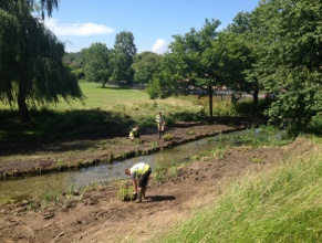
|Project summary=This project is located on Desborough recreation grounds towards the west of Wycombe. The river Wye flows through council parkland which is surrounded by domestic and commercial developments and two busy roads. It is a popular site for dog walking and is used regularly by the local community and school. It's a highly valued recreational area. | |||
'''Aims''' | |||
* Increased habitat diversity within the watercourse and along marginal zones to include the increase and diversity of nursery habitat. | |||
* Enhance local aquatic vegetation, benthic communities and fish populations helping to improve ecological status (as measured under the WFD). | |||
* Improve ecosystem services and aesthetic value for the local community and park users. | |||
'''Implementations''' | |||
* Remove and dispose of concrete revetment from the banks of selected sections of watercourse. | |||
* Remove and remediate a concrete fish-pass, which is largely ineffective, favor of a more naturalised channel. | |||
* Excavate a new meander in place of the fish-pass to lengthen the watercourse and decrease water velocity. | |||
* Re-grade and re-profile the river bed and banks in selected sections to reduce the width of over-wide channels and create a narrower self-cleansing system. | |||
* Define a more sinuous bank edge with coir rolls and brushwood faggots. | |||
* Install soft revetment along selected sections of the river helping to promote marginal growth and prevent bank erosion. | |||
* Restore and enhance marginal vegetation through planting of aquatic and marginal plants. | |||
* Engage with local schools and provide learning opportunities for pupils. | |||
As well as these there were also a few smaller actions that the project looked to do. These included the use of environmentally friendly plant equipment a vibrating post driver which is more environmentally friendly than a regular post driver. Like most restoration projects there were also some constraints that had to be considered. These included flood risk, project waste disposal and maintaining park safety. In total the project cost £80,000 and took 25 days. | |||
}} | }} | ||
{{Image gallery}} | {{Image gallery}} | ||
{{Case study image | |||
|File name=Untitled1.jpg | |||
|Caption=New flow deflectors (High Wycombe District Council) | |||
}} | |||
{{Case study image | |||
|File name=Untitled4.jpg | |||
|Caption=Before and after image (High Wycombe District Council) | |||
}} | |||
{{Case study image | |||
|File name=Untitled3.jpg | |||
|Caption=Before during and after image (High Wycombe District Council) | |||
}} | |||
{{Image gallery end}} | {{Image gallery end}} | ||
{{Toggle button}} | {{Toggle button}} | ||
{{Toggle content start}} | {{Toggle content start}} | ||
{{Case study subcatchment}} | {{Case study subcatchment | ||
{{Site}} | |Subcatchment=Wye (Source to High Wycombe fire station) | ||
{{Project background}} | }} | ||
{{Site | |||
|WFD water body code=GB106039023890 | |||
|WFD water body name=Wye (Source to High Wycombe fire station) | |||
|Heavily modified water body=No | |||
|Protected species present=No | |||
|Invasive species present=No | |||
}} | |||
{{Project background | |||
|Project started=2014/06/01 | |||
|Works started=2014/06/16 | |||
|Works completed=2014/07/11 | |||
|Project completed=2014/07/11 | |||
|Total1 cost=80 | |||
}} | |||
{{Motivations}} | {{Motivations}} | ||
{{Measures}} | {{Measures}} | ||
Latest revision as of 13:10, 2 November 2015
Project overview
| Status | Complete |
|---|---|
| Project web site | |
| Themes | Environmental flows and water resources, Fisheries, Habitat and biodiversity, Hydromorphology, Social benefits, Urban |
| Country | England |
| Main contact forename | Joshua |
| Main contact surname | Robins |
| Main contact user ID | User:JoshRRC |
| Contact organisation | High Wycombe District Council; River Restoration Centre |
| Contact organisation web site | |
| Partner organisations | Five Rivers Environmental Contracting Ltd (5R), Environment Agency, Wild Trout Trust, Chiltern Society, Chiltern Chalk Streams Project, Wycombe Wildlife Group, High Wycombe Society |
| Parent multi-site project | |
| This is a parent project encompassing the following projects |
No |
Project summary
This project is located on Desborough recreation grounds towards the west of Wycombe. The river Wye flows through council parkland which is surrounded by domestic and commercial developments and two busy roads. It is a popular site for dog walking and is used regularly by the local community and school. It's a highly valued recreational area.
Aims
- Increased habitat diversity within the watercourse and along marginal zones to include the increase and diversity of nursery habitat.
- Enhance local aquatic vegetation, benthic communities and fish populations helping to improve ecological status (as measured under the WFD).
- Improve ecosystem services and aesthetic value for the local community and park users.
Implementations
- Remove and dispose of concrete revetment from the banks of selected sections of watercourse.
- Remove and remediate a concrete fish-pass, which is largely ineffective, favor of a more naturalised channel.
- Excavate a new meander in place of the fish-pass to lengthen the watercourse and decrease water velocity.
- Re-grade and re-profile the river bed and banks in selected sections to reduce the width of over-wide channels and create a narrower self-cleansing system.
- Define a more sinuous bank edge with coir rolls and brushwood faggots.
- Install soft revetment along selected sections of the river helping to promote marginal growth and prevent bank erosion.
- Restore and enhance marginal vegetation through planting of aquatic and marginal plants.
- Engage with local schools and provide learning opportunities for pupils.
As well as these there were also a few smaller actions that the project looked to do. These included the use of environmentally friendly plant equipment a vibrating post driver which is more environmentally friendly than a regular post driver. Like most restoration projects there were also some constraints that had to be considered. These included flood risk, project waste disposal and maintaining park safety. In total the project cost £80,000 and took 25 days.
Monitoring surveys and results
Lessons learnt
Image gallery
|
Catchment and subcatchmentSelect a catchment/subcatchment
Catchment
Subcatchment
Site
Project background
Cost for project phases
Reasons for river restoration
Measures
MonitoringHydromorphological quality elements
Biological quality elements
Physico-chemical quality elements
Any other monitoring, e.g. social, economic
Monitoring documents
Additional documents and videos
Additional links and references
Supplementary InformationEdit Supplementary Information
| ||||||||||||||||||||||||||||||||||||||||||||||||||||||||||||||||||||||||||||||||||||||||||||||||||||||||||||||||||||||||||||||||||||||||||||||||||||||||||||||||||||||||||||||||||||||||||||||||||||||||


