Case study:Eastridge Estate restoration project: Difference between revisions
No edit summary |
No edit summary |
||
| (17 intermediate revisions by 2 users not shown) | |||
| Line 1: | Line 1: | ||
{{Case study status | {{Case study status | ||
|Approval status= | |Approval status=Approved | ||
}} | }} | ||
{{Location | {{Location | ||
| Line 9: | Line 9: | ||
|Themes=Environmental flows and water resources, Fisheries, Habitat and biodiversity, Hydromorphology | |Themes=Environmental flows and water resources, Fisheries, Habitat and biodiversity, Hydromorphology | ||
|Country=England | |Country=England | ||
|Main contact forename= | |Main contact forename=Vaughan | ||
|Main contact surname= | |Main contact surname=Lewis | ||
|Contact organisation=Eastridge Estate and Windrush AEC Ltd | |Contact organisation=Eastridge Estate and Windrush AEC Ltd | ||
|Partner organisations= | |Partner organisations=Natural England, Environment Agency, | ||
|Multi-site=No | |Multi-site=No | ||
|Project summary=The River Kennet was the subject | |Project picture=Narrowing.jpg | ||
|Picture description=The newly narrowed channel | |||
|Project summary=The River Kennet was the subject overviews by the Environment Agency and Natural England. These overviews revealed that the Kennet was in an unfavourable condition with respect to its SSSI designation. Problems included barriers to fish migration, of which there were 3 major and 1 minor. Barriers usually refer to weirs which completely block any way for fish and eels to get to their spawning grounds. Weirs can also prevent the conveyance of sediments throughout a reach. The water meadows surrounding the channel were also classified as being in 'poor' condition. | |||
The project appears to have been a success with many of the objectives | |||
The project objectives were to: | |||
*Achieve favourable condition for the length of the Kennet through the estate. | |||
*Achieve favourable condition for the Kennet, Lambourn and water meadows on the estate. | |||
*Increase hydrological connectivity between the river and floodplain. | |||
*Remove barriers to fish migration. | |||
*Improve wild trout numbers. | |||
*Improve the overall water quality of the fishery. | |||
The measures used to combat these issues included the introduction of 3,000 tonnes of gravel along the profile. This was to allow for the formation of natural features such as riffles. The channel was narrowed by 5m in places to also allow for natural flows and variations withinin the channel. To address the four barriers to migration, fish and eel passes were built. Trees were cut back to reduce the amount of shade and introduce more light into the channel. | |||
At points along the reach the banks were lowered to promote flooding onto the wetlands. Parts of the wetlands were also excavated to provide a better environment for the wildlife on the wetlands. | |||
|Monitoring surveys and results=The project appears to have been a success with many of the objectives being achieved. There is evidence of changes to the morphology and flow patterns in the newly enhanced channel. The channel is also free of any significant impoundments, with increases in gravel bedded habitats. There also appears to be a increases in the abundance and diversity of submerged and emergent macrophytes in the channel and along its margins. Fish populations of fish have also increased and it is hoped that one day there will be a self sustaining population. | |||
}} | }} | ||
{{Image gallery}} | {{Image gallery}} | ||
{{Case study image | |||
|File name=Riffle.jpg | |||
}} | |||
{{Case study image | |||
|File name=Newgravel.jpg | |||
}} | |||
{{Case study image | |||
|File name=Fishpass.jpg | |||
}} | |||
{{Image gallery end}} | {{Image gallery end}} | ||
{{Toggle button}} | {{Toggle button}} | ||
{{Toggle content start}} | {{Toggle content start}} | ||
{{Case study subcatchment}} | {{Case study subcatchment | ||
{{Site}} | |Subcatchment=Middle Kennet (Marlborough to Newbury) | ||
{{Project background}} | }} | ||
{{Site | |||
|WFD water body code=GB106039023172 | |||
|WFD water body name=Middle Kennet (Marlborough to Newbury) | |||
|Heavily modified water body=No | |||
|Protected species present=No | |||
|Invasive species present=No | |||
}} | |||
{{Project background | |||
|Works started=2012/09/01 | |||
|Project completed=2013/10/01 | |||
|Total cost category=100 - 500 k€ | |||
|Funding sources=Environment Agency, | |||
}} | |||
{{Motivations | {{Motivations | ||
|Hydromorphological quality elements=Poor river connectivity | |Hydromorphological quality elements=Poor river connectivity | ||
|Biological quality elements=Barriers to fish migration | |Biological quality elements=Barriers to fish migration | ||
}} | }} | ||
{{Measures}} | {{Measures | ||
|Bank and bed modifications measure=Creation of fish passes, Introduction of gravel, | |||
|Floodplain / River corridor=lowering river bank | |||
|Planform / Channel pattern=Channel narrowing, Introducing large woody debris, | |||
}} | |||
{{Hydromorphological quality elements header}} | {{Hydromorphological quality elements header}} | ||
{{End table}} | {{End table}} | ||
Latest revision as of 12:39, 1 June 2017
Project overview
| Status | Complete |
|---|---|
| Project web site | |
| Themes | Environmental flows and water resources, Fisheries, Habitat and biodiversity, Hydromorphology |
| Country | England |
| Main contact forename | Vaughan |
| Main contact surname | Lewis |
| Main contact user ID | |
| Contact organisation | Eastridge Estate and Windrush AEC Ltd |
| Contact organisation web site | |
| Partner organisations | Natural England, Environment Agency |
| Parent multi-site project | |
| This is a parent project encompassing the following projects |
No |
Project summary
The River Kennet was the subject overviews by the Environment Agency and Natural England. These overviews revealed that the Kennet was in an unfavourable condition with respect to its SSSI designation. Problems included barriers to fish migration, of which there were 3 major and 1 minor. Barriers usually refer to weirs which completely block any way for fish and eels to get to their spawning grounds. Weirs can also prevent the conveyance of sediments throughout a reach. The water meadows surrounding the channel were also classified as being in 'poor' condition.
The project objectives were to:
- Achieve favourable condition for the length of the Kennet through the estate.
- Achieve favourable condition for the Kennet, Lambourn and water meadows on the estate.
- Increase hydrological connectivity between the river and floodplain.
- Remove barriers to fish migration.
- Improve wild trout numbers.
- Improve the overall water quality of the fishery.
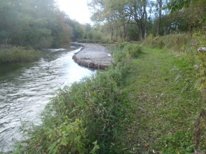
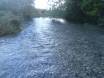
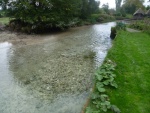
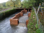
The measures used to combat these issues included the introduction of 3,000 tonnes of gravel along the profile. This was to allow for the formation of natural features such as riffles. The channel was narrowed by 5m in places to also allow for natural flows and variations withinin the channel. To address the four barriers to migration, fish and eel passes were built. Trees were cut back to reduce the amount of shade and introduce more light into the channel.
At points along the reach the banks were lowered to promote flooding onto the wetlands. Parts of the wetlands were also excavated to provide a better environment for the wildlife on the wetlands.
Monitoring surveys and results
The project appears to have been a success with many of the objectives being achieved. There is evidence of changes to the morphology and flow patterns in the newly enhanced channel. The channel is also free of any significant impoundments, with increases in gravel bedded habitats. There also appears to be a increases in the abundance and diversity of submerged and emergent macrophytes in the channel and along its margins. Fish populations of fish have also increased and it is hoped that one day there will be a self sustaining population.
Lessons learnt
Image gallery
|
Catchment and subcatchmentSelect a catchment/subcatchment
Catchment
Subcatchment
Other case studies in this subcatchment: Habitat Improvement: Stonebridge River Reserve, Og and Marlborough Fish Migration, River Kennet Restoration at Durnsford
Site
Project background
Cost for project phases
Reasons for river restoration
Measures
MonitoringHydromorphological quality elements
Biological quality elements
Physico-chemical quality elements
Any other monitoring, e.g. social, economic
Monitoring documents
Additional documents and videos
Additional links and references
Supplementary InformationEdit Supplementary Information
| ||||||||||||||||||||||||||||||||||||||||||||||||||||||||||||||||||||||||||||||||||||||||||||||||||||||||||||||||||||||||||||||||||||||||||||||||||||||||||||||||||||||||||||||||||||||||||||||||||||||||


