Case study:Queensbury Recreation Ground: Difference between revisions
No edit summary |
No edit summary |
||
| (12 intermediate revisions by 4 users not shown) | |||
| Line 1: | Line 1: | ||
{{ | {{Case study status | ||
|Approval status= | |Approval status=Approved | ||
}} | }} | ||
{{Location | {{Location | ||
| Line 18: | Line 11: | ||
|Main contact forename=Michael | |Main contact forename=Michael | ||
|Main contact surname=Bradshaw | |Main contact surname=Bradshaw | ||
|Contact organisation=London Borough of Harrow | |||
|Partner organisations=Drain London | |Partner organisations=Drain London | ||
|Multi-site=No | |Multi-site=No | ||
|Project picture=Queensbury Park 181215 001.JPG | |||
|Picture description=Queensbury Park | |||
|Project summary=To create space for water, improve biodiversity and habitat, bring the river into the park to make it an accessible feature and improve water quality. Local park with river running north to south along its boundary. Fenced off from the park and and housing, inaccessible and prone to fly tipping. The water quality is poor due to misconnected waste water. There is no/few habitat or aquatic waterborne fauna. | |Project summary=To create space for water, improve biodiversity and habitat, bring the river into the park to make it an accessible feature and improve water quality. Local park with river running north to south along its boundary. Fenced off from the park and and housing, inaccessible and prone to fly tipping. The water quality is poor due to misconnected waste water. There is no/few habitat or aquatic waterborne fauna. | ||
The first phase of this project is complete and a local community group is establishing to work with the council and a local school to keep the river and flood storage area in good order. Sufficient monitoring is necessary due to pollution issues from sewers, however the next phase of the project is being planned. A reed bed system is to be installed to aid the restoration. | |||
|Monitoring surveys and results=Photographs pre-works | |||
}} | }} | ||
{{Image_gallery}} | {{Image_gallery}} | ||
| Line 26: | Line 25: | ||
{{Toggle_button}} | {{Toggle_button}} | ||
{{Toggle_content_start}} | {{Toggle_content_start}} | ||
{{ | {{Case study subcatchment | ||
|Subcatchment= | |Subcatchment=Wealdstone Brook | ||
}} | }} | ||
{{Site | {{Site | ||
|WFD water body code=GB106039022940 | |||
|WFD water body name=Wealdstone Brook | |||
|Heavily modified water body=No | |||
|Protected species present=No | |||
|WFD water body code= | |Invasive species present=No | ||
|WFD water body name= | |||
|Heavily modified water body= | |||
|Protected species present= | |||
|Invasive species present= | |||
}} | }} | ||
{{Project background | {{Project background | ||
| Line 91: | Line 40: | ||
|Works completed=2012/01/01 | |Works completed=2012/01/01 | ||
|Total cost category=10 - 50 k€ | |Total cost category=10 - 50 k€ | ||
|Funding sources=Environment Agency, London Borough of Harrow | |||
}} | }} | ||
{{Motivations | {{Motivations | ||
|Specific mitigation=Pollution incident, Urbanisation | |||
|Other motivation=Landscape enhancement, Recreation | |||
|Specific mitigation= | |||
|Other motivation= | |||
}} | }} | ||
{{Measures | {{Measures | ||
|Social measures=Improved public access | |||
|Social measures= | |||
}} | }} | ||
{{Hydromorphological_quality_elements_header}} | {{Hydromorphological_quality_elements_header}} | ||
Latest revision as of 12:56, 1 November 2018
Project overview
| Status | Complete |
|---|---|
| Project web site | |
| Themes | Fisheries, Flood risk management, Habitat and biodiversity, Social benefits |
| Country | England |
| Main contact forename | Michael |
| Main contact surname | Bradshaw |
| Main contact user ID | |
| Contact organisation | London Borough of Harrow |
| Contact organisation web site | |
| Partner organisations | Drain London |
| Parent multi-site project | |
| This is a parent project encompassing the following projects |
No |
Project summary
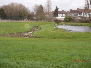
To create space for water, improve biodiversity and habitat, bring the river into the park to make it an accessible feature and improve water quality. Local park with river running north to south along its boundary. Fenced off from the park and and housing, inaccessible and prone to fly tipping. The water quality is poor due to misconnected waste water. There is no/few habitat or aquatic waterborne fauna.
The first phase of this project is complete and a local community group is establishing to work with the council and a local school to keep the river and flood storage area in good order. Sufficient monitoring is necessary due to pollution issues from sewers, however the next phase of the project is being planned. A reed bed system is to be installed to aid the restoration.
Monitoring surveys and results
Photographs pre-works
Lessons learnt
Image gallery
|
Catchment and subcatchmentSelect a catchment/subcatchment
Catchment
Subcatchment
Other case studies in this subcatchment: Wealdstone Brook
Site
Project background
Cost for project phases
Reasons for river restoration
Measures
MonitoringHydromorphological quality elements
Biological quality elements
Physico-chemical quality elements
Any other monitoring, e.g. social, economic
Monitoring documents
Additional documents and videos
Additional links and references
Supplementary InformationEdit Supplementary Information
| ||||||||||||||||||||||||||||||||||||||||||||||||||||||||||||||||||||||||||||||||||||||||||||||||||||||||||||||||||||||||||||||||||||||||||||||||||||||||||||||||||||||||||||||||||||||||||||||||||||||||

