Case study:Chambers Wharf: Difference between revisions
No edit summary |
No edit summary |
||
| (15 intermediate revisions by 4 users not shown) | |||
| Line 1: | Line 1: | ||
{{Project overview | {{Project overview | ||
|Status=Complete | |||
|Status= | |Themes=Estuary, Flood risk management, Habitat and biodiversity, Spatial planning, Urban | ||
|Themes=Spatial planning | |||
|Country=England | |Country=England | ||
|Main contact forename=James | |Main contact forename=James | ||
| Line 14: | Line 7: | ||
|Contact organisation=Environment Agency | |Contact organisation=Environment Agency | ||
|Contact organisation url=www.environment-agency.gov.uk | |Contact organisation url=www.environment-agency.gov.uk | ||
|Partner organisations=St Martins Property Investments Ltd; Simpson Haugh & Partners; Southwark Council; St James; Peabody; Greater London Authority | |||
|Multi-site=No | |Multi-site=No | ||
|Project picture=Chambers Wharf.jpg | |||
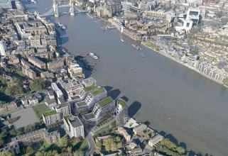
|Picture description=A graphic of what Chambers Wharf will look like | |||
|Project summary=Situated just to the east of Tower Bridge on the south bank of the River Thames, Chambers Wharf was for many years one of the capital’s major cold stores. Having fallen into disuse, the site, owned by international property development company St Martins, now has planning permission for 587 new homes; 180 of these homes will be affordable and there will be some retail units at ground level, fronting Chambers Street. Demolition of the former cold stores has been completed and the new scheme is scheduled to be finished in 2013. | |||
|Monitoring surveys and results=* https://www.simpsonhaugh.com/projects/chambers-wharf | |||
* http://newlondondevelopment.com/nld/project/chambers_wharf | |||
* https://www.peabody.org.uk/homes-in-development/southwark/chambers-wharf | |||
}} | |||
{{Case study status | |||
|Approval status=Approved | |||
}} | |||
{{Location | |||
|Location=51.50077385060271, -0.06569155918577962 | |||
}} | |||
{{Image gallery}} | |||
{{Image gallery end}} | |||
{{Toggle button}} | |||
{{Toggle content start}} | |||
{{Case study subcatchment | |||
|Subcatchment=THAMES MIDDLE | |||
}} | }} | ||
{{Site | {{Site | ||
|Name=Chambers Wharf | |Name=Chambers Wharf | ||
|WFD water body code=GB530603911402 | |WFD water body code=GB530603911402 | ||
|WFD (national) typology= | |WFD (national) typology=Intertidal | ||
|WFD water body name= | |WFD water body name=Thames Middle | ||
|Heavily modified water body=Yes | |Heavily modified water body=Yes | ||
|Site designation=EU - WFD protected area (drinking water, shellfish etc.) | |Site designation=EU - WFD protected area (drinking water, shellfish etc.) | ||
|Protected species present=Yes | |Protected species present=Yes | ||
|Invasive species present=Yes | |Invasive species present=Yes | ||
|Dominant hydrology=Estuary, | |Dominant hydrology=Estuary, | ||
|Dominant substrate=Estuarine mud, | |Dominant substrate=Estuarine mud, | ||
|River corridor land use=Urban, | |River corridor land use=Urban, | ||
}} | }} | ||
{{Project background | {{Project background | ||
| Line 36: | Line 51: | ||
|Funding sources=St Martins Property Investments Ltd | |Funding sources=St Martins Property Investments Ltd | ||
}} | }} | ||
{{Motivations}} | {{Motivations | ||
{{Measures}} | |Specific mitigation=Flood risk management, Navigation, | ||
|Hydromorphological quality elements=Structure & condition of intertidal zone, | |||
|Biological quality elements=Macroalgae, Invertebrates, | |||
|Other motivation=housing development | |||
}} | |||
{{Measures | |||
|Bank and bed modifications measure=Bank improvement | |||
|Planform / Channel pattern=removal of jetty | |||
|Other technical measure=roosting posts, Brownfield land regeneration, green roofs, SUDS, nesting boxes | |||
|Social measures=Riverside walkway, | |||
}} | |||
{{Hydromorphological quality elements header}} | {{Hydromorphological quality elements header}} | ||
{{End table}} | {{End table}} | ||
| Line 48: | Line 73: | ||
{{Monitoring documents}} | {{Monitoring documents}} | ||
{{Monitoring documents end}} | {{Monitoring documents end}} | ||
{{Additional Documents}} | {{Additional Documents}} | ||
{{Case study documents | |||
|File name=Thamescasestudies.pdf | |||
|Description=Good Practice case study 1 | |||
}} | |||
{{Additional Documents end}} | {{Additional Documents end}} | ||
{{Additional links and references header}} | {{Additional links and references header}} | ||
{{Additional links and references footer}} | {{Additional links and references footer}} | ||
{{Supplementary Information}} | {{Supplementary Information}} | ||
{{Toggle content end}} | |||
Latest revision as of 20:46, 3 October 2024
Project overview
| Status | Complete |
|---|---|
| Project web site | |
| Themes | Estuary, Flood risk management, Habitat and biodiversity, Spatial planning, Urban |
| Country | England |
| Main contact forename | James |
| Main contact surname | Togher |
| Main contact user ID | |
| Contact organisation | Environment Agency |
| Contact organisation web site | http://www.environment-agency.gov.uk |
| Partner organisations | St Martins Property Investments Ltd; Simpson Haugh & Partners; Southwark Council; St James; Peabody; Greater London Authority |
| Parent multi-site project | |
| This is a parent project encompassing the following projects |
No |
Project summary
Situated just to the east of Tower Bridge on the south bank of the River Thames, Chambers Wharf was for many years one of the capital’s major cold stores. Having fallen into disuse, the site, owned by international property development company St Martins, now has planning permission for 587 new homes; 180 of these homes will be affordable and there will be some retail units at ground level, fronting Chambers Street. Demolition of the former cold stores has been completed and the new scheme is scheduled to be finished in 2013.
Monitoring surveys and results
Lessons learnt
Image gallery
|
Catchment and subcatchmentSelect a catchment/subcatchment
Catchment
Subcatchment
Other case studies in this subcatchment: Barking Creek near A13, Barking Creekmouth, Cuckolds Haven Nature Area, Greenwich Peninsula, Lower River Roding Regeneration Project, Mill Pool, Saving Chiswick Eyot, Wandsworth Riverside Quarter
Site
Project background
Cost for project phases
Reasons for river restoration
Measures
MonitoringHydromorphological quality elements
Biological quality elements
Physico-chemical quality elements
Any other monitoring, e.g. social, economic
Monitoring documents
Additional documents and videos
Additional links and references
Supplementary InformationEdit Supplementary Information
| ||||||||||||||||||||||||||||||||||||||||||||||||||||||||||||||||||||||||||||||||||||||||||||||||||||||||||||||||||||||||||||||||||||||||||||||||||||||||||||||||||||||||||||||||||||||||||||||

