Case study:River Marden at Calne: Difference between revisions
No edit summary |
No edit summary |
||
| (6 intermediate revisions by 4 users not shown) | |||
| Line 1: | Line 1: | ||
{{Case study status | {{Case study status | ||
|Approval status= | |Approval status=Approved | ||
}} | }} | ||
{{Location | {{Location | ||
| Line 22: | Line 22: | ||
The scheme has been a success and the river is now a focal point of the town and the centerpiece for the towns annual duck race! | The scheme has been a success and the river is now a focal point of the town and the centerpiece for the towns annual duck race! | ||
}} | }} | ||
{{Case study subcatchment}} | {{Image gallery}} | ||
{{Case study image | |||
|File name=Marden before.jpg | |||
|Caption=River Marden before restoration looking downstream | |||
}} | |||
{{Case study image | |||
|File name=Marden before upstream.png | |||
|Caption=River Marden before restoration looking upstream | |||
}} | |||
{{Case study image | |||
|File name=2012.JPG | |||
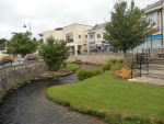
|Caption=Re-meandered channel and riverside access - 2012 | |||
}} | |||
{{Case study image | |||
|File name=Floods 2012.JPG | |||
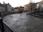
|Caption=Scheme holding up well in floods - 2012 | |||
}} | |||
{{Case study image | |||
|File name=Calne Duck Race 19.05.07 0192.jpg | |||
|Caption=Calne charity duck race - 2007 | |||
}} | |||
{{Image gallery end}} | |||
{{Toggle button}} | |||
{{Toggle content start}} | |||
{{Case study subcatchment | |||
|Subcatchment=R Marden - conf Abberd Bk to conf unnamed trib | |||
}} | |||
{{Site | {{Site | ||
|Name=River Marden at Calne | |Name=River Marden at Calne | ||
|WFD water body code=GB109053022060 | |WFD water body code=GB109053022060 | ||
|Pre-project morphology=Straightened, Artificial bed, | |WFD water body name=R Marden - conf Abberd Bk to conf unnamed trib | ||
|Reference morphology=Bedrock cascade, Sinuous, | |Pre-project morphology=Straightened, Artificial bed, | ||
|Reference morphology=Bedrock cascade, Sinuous, | |||
|Heavily modified water body=Yes | |Heavily modified water body=Yes | ||
|Protected species present=No | |Protected species present=No | ||
|Invasive species present=No | |Invasive species present=No | ||
|Dominant substrate=Chalk | |Dominant substrate=Chalk | ||
|River corridor land use=Urban | |River corridor land use=Urban | ||
}} | }} | ||
{{Project background | {{Project background | ||
| Line 47: | Line 75: | ||
}} | }} | ||
{{Measures | {{Measures | ||
|Bank and bed modifications measure=Bedrock cascades and outcrops, Creation of pools and riffles, Creation of shoals/berms, | |Bank and bed modifications measure=Bedrock cascades and outcrops, Creation of pools and riffles, Creation of shoals/berms, Weir removal, | ||
|Floodplain / River corridor=Public access to the river, | |Floodplain / River corridor=Public access to the river, | ||
|Planform / Channel pattern= | |Planform / Channel pattern=Re-meandering, | ||
|Other technical measure=Replacement existing culvert with twin culvert | |Other technical measure=Replacement existing culvert with twin culvert | ||
|Social measures=Improved public access, Focal point for local events | |Social measures=Improved public access, Focal point for local events | ||
| Line 72: | Line 100: | ||
{{Monitoring documents}} | {{Monitoring documents}} | ||
{{Monitoring documents end}} | {{Monitoring documents end}} | ||
{{Additional Documents}} | {{Additional Documents}} | ||
{{Additional Documents end}} | {{Additional Documents end}} | ||
| Line 111: | Line 118: | ||
{{Additional links and references footer}} | {{Additional links and references footer}} | ||
{{Supplementary Information}} | {{Supplementary Information}} | ||
{{Toggle content end}} | |||
Latest revision as of 15:00, 2 January 2019
Project overview
| Status | Complete |
|---|---|
| Project web site | |
| Themes | Flood risk management, Habitat and biodiversity, Social benefits |
| Country | England |
| Main contact forename | Paul |
| Main contact surname | Jolliffe |
| Main contact user ID | |
| Contact organisation | Nicholas Pearson Associates |
| Contact organisation web site | http://www.npaconsult.co.uk/ |
| Partner organisations | |
| Parent multi-site project | |
| This is a parent project encompassing the following projects |
No |
Project summary
Following the demolition of a town centre factory, the River Marden through Calne flowed in a straight concrete channel and two small weirs barred the passage of fish. Urban regeneration, and the resultant redevelopment of the site, meant that the river had to be diverted south of its existing course and the opportunity was taken to improve the character of the river and create a public amenity.
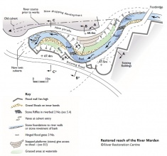
The diversion was undertaken in the form of a double meander so that natural geomorphological features such as shoals, riffles and pools could be incorporated, along with public access to the river and the creation of a variety of sustainable, attractive habitats for flora and fauna.
The scheme has been a success and the river is now a focal point of the town and the centerpiece for the towns annual duck race!
Monitoring surveys and results
Lessons learnt
Image gallery
|
Catchment and subcatchmentSelect a catchment/subcatchment
Catchment
Subcatchment
Site
Project background
Cost for project phases
Supplementary funding informationExact costs for the project are not available but would have been "considerable" given the works required
Reasons for river restoration
Measures
MonitoringHydromorphological quality elements
Biological quality elements
Physico-chemical quality elements
Any other monitoring, e.g. social, economic
Monitoring documents
Additional documents and videos
Additional links and references
Supplementary InformationEdit Supplementary Information
| |||||||||||||||||||||||||||||||||||||||||||||||||||||||||||||||||||||||||||||||||||||||||||||||||||||||||||||||||||||||||||||||||||||||||||||||||||||||||||||||||||||||||||||||||||||||||||||||||||||||||||


