Case study:Dove Weir removal: Difference between revisions
Jump to navigation
Jump to search
No edit summary |
No edit summary |
||
| (18 intermediate revisions by 5 users not shown) | |||
| Line 1: | Line 1: | ||
{{ | {{Case study status | ||
|Approval status= | |Approval status=Approved | ||
}} | }} | ||
{{Location | {{Location | ||
| Line 17: | Line 12: | ||
|Themes=Habitat and biodiversity, Hydromorphology, Land use management - agriculture, Monitoring, Spatial planning | |Themes=Habitat and biodiversity, Hydromorphology, Land use management - agriculture, Monitoring, Spatial planning | ||
|Country=England | |Country=England | ||
|Main contact forename= | |Main contact forename=Alex | ||
|Main contact surname= | |Main contact surname=Swann | ||
|Contact organisation=Leek and District Fly Fishing Association | |||
|Contact organisation | |||
|Multi-site=No | |Multi-site=No | ||
|Project picture=100 0413.JPG | |Project picture=100 0413.JPG | ||
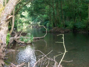
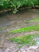
|Picture description=River Dove downstream of weir removal, with introduced woody debris | |Picture description=River Dove downstream of weir removal, with introduced woody debris | ||
|Project summary=The Leek and District Fly Fishing Association (LDFFA) undertook work to remove an artificial weir in an attempt to restore a more natural flow to the river. The river was also 're-wilded' to introduce woody debris and other material to enhance fish habitats. | |Project summary=The Leek and District Fly Fishing Association (LDFFA) undertook work to remove an artificial weir in an attempt to restore a more natural flow to the river. The river was also 're-wilded' to introduce woody debris and other material to enhance fish habitats. | ||
Warning signs provided to stop public removing debris or rebuilding weirs. | |||
}} | |||
{{Image gallery}} | |||
{{Case study image | |||
|File name=100 0399edited.JPG | |||
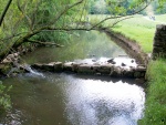
|Caption=Example of an existing weir upstream of works, August 2011 | |||
}} | |||
{{Case study image | |||
|File name=100 0405.JPG | |||
|Caption=One of the sites of weir removal, August 2011 | |||
}} | }} | ||
{{ | {{Case study image | ||
| | |File name=100 0404.JPG | ||
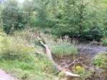
|Caption=Introduced woody debris and establishment of vegetation within 12 months, August 2011 | |||
}} | |||
{{Case study image | |||
|File name=100 0411.JPG | |||
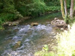
|Caption=Created riffles | |||
}} | |||
{{Image_gallery_end}} | |||
{{Toggle button}} | |||
{{Toggle content start}} | |||
{{Case study subcatchment | |||
|Subcatchment=R Maniford/Dove from R Hamps to R Churnet | |||
}} | }} | ||
{{Site | {{Site | ||
|Name=Dovedale | |Name=Dovedale | ||
|WFD water body code=GB104028052670 | |||
|WFD water body name=R Maniford/Dove from R Hamps to R Churnet | |||
|Pre-project morphology=Single channel,Impounded,High width:depth,Embanked | |Pre-project morphology=Single channel,Impounded,High width:depth,Embanked | ||
|Reference morphology=Single channel,Pool-riffle | |Reference morphology=Single channel,Pool-riffle | ||
| Line 48: | Line 62: | ||
|Average bankfull channel depth category=5 - 10 m | |Average bankfull channel depth category=5 - 10 m | ||
}} | }} | ||
{{ | {{Project background | ||
|Reach length directly affected= | |Reach length directly affected=1000 m | ||
|Project started=2010/07/01 | |||
|Works completed=2010/08/01 | |||
|Total cost category=1 - 10 k€ | |||
|Project started= | |Total1 cost=2 k€ | ||
|Funding sources=Leek and District Fly Fishing Association | |||
|Investigation and design Lead organisation=Leek and District Fly Fishing Association | |||
|Stakeholder engagement Lead organisation=Leek and District Fly Fishing Association | |||
|Works completed= | |Works and supervision Lead organisation=Leek and District Fly Fishing Association | ||
|Post-project management and maintenance Lead organisation=Leek and District Fly Fishing Association | |||
|Monitoring Lead organisation=Leek and District Fly Fishing Association | |||
|Total cost category= | |||
|Total1 cost= | |||
|Funding sources= | |||
|Investigation and design Lead organisation= | |||
|Stakeholder engagement Lead organisation= | |||
|Works and supervision Lead organisation= | |||
|Post-project management and maintenance Lead organisation= | |||
|Monitoring Lead organisation= | |||
}} | }} | ||
{{Motivations | {{Motivations | ||
| Line 135: | Line 90: | ||
}} | }} | ||
{{Measures | {{Measures | ||
|Bank and bed modifications measure= | |Bank and bed modifications measure=Vegetation cut back, Weir removal, | ||
|Floodplain / River corridor=Cut back of trees, Introducing large woody debris, | |||
|Planform / Channel pattern=Adding sinuosity, | |||
|Social measures=Information for the public, | |||
|Floodplain / River corridor= | |||
|Planform / Channel pattern= | |||
|Social measures= | |||
}} | }} | ||
{{Hydromorphological_quality_elements_header}} | {{Hydromorphological_quality_elements_header}} | ||
| Line 219: | Line 162: | ||
{{Monitoring_documents}} | {{Monitoring_documents}} | ||
{{Monitoring_documents_end}} | {{Monitoring_documents_end}} | ||
{{Additional_Documents}} | {{Additional_Documents}} | ||
{{Additional_Documents_end}} | {{Additional_Documents_end}} | ||
{{ | {{Additional links and references header}} | ||
{{Additional links and references | |||
|Link=www.therrc.co.uk/case_studies/dove%20at%20dovedale.pdf | |||
|Description=River Restoration Centre Case Study | |||
}} | |||
{{Additional_links_and_references_footer}} | {{Additional_links_and_references_footer}} | ||
{{Supplementary_Information | {{Supplementary_Information | ||
| Line 245: | Line 190: | ||
}} | }} | ||
{{Case_study_upload}} | {{Case_study_upload}} | ||
{{Toggle content end}} | |||
Latest revision as of 15:00, 2 January 2019
Location: 53° 2' 0.13" N, 1° 45' 39.48" W
Left click to look around in the map, and use the wheel of your mouse to zoom in and out.
Project overview
| Status | Complete |
|---|---|
| Project web site | |
| Themes | Habitat and biodiversity, Hydromorphology, Land use management - agriculture, Monitoring, Spatial planning |
| Country | England |
| Main contact forename | Alex |
| Main contact surname | Swann |
| Main contact user ID | |
| Contact organisation | Leek and District Fly Fishing Association |
| Contact organisation web site | |
| Partner organisations | |
| Parent multi-site project | |
| This is a parent project encompassing the following projects |
No |
Project summary
Edit project overview to modify the project summary.
The Leek and District Fly Fishing Association (LDFFA) undertook work to remove an artificial weir in an attempt to restore a more natural flow to the river. The river was also 're-wilded' to introduce woody debris and other material to enhance fish habitats.
Warning signs provided to stop public removing debris or rebuilding weirs.
Monitoring surveys and results
This case study hasn’t got any Monitoring survey and results, you can add some by editing the project overview.
Lessons learnt
This case study hasn’t got any lessons learnt, you can add some by editing the project overview.
Image gallery
|
Catchment and subcatchmentSelect a catchment/subcatchment
Catchment
Subcatchment
Site
Project background
Cost for project phases
Reasons for river restoration
Measures
MonitoringHydromorphological quality elements
Biological quality elements
Physico-chemical quality elements
Any other monitoring, e.g. social, economic
Monitoring documents
Additional documents and videos
Additional links and references
Supplementary InformationEdit Supplementary Information
| |||||||||||||||||||||||||||||||||||||||||||||||||||||||||||||||||||||||||||||||||||||||||||||||||||||||||||||||||||||||||||||||||||||||||||||||||||||||||||||||||||||||||||||||||||||||||||||||||||||||||||||||||||||

