Case study:Ladywell Fields (QUERCUS): Difference between revisions
No edit summary |
No edit summary |
||
| (40 intermediate revisions by 7 users not shown) | |||
| Line 1: | Line 1: | ||
{{ | {{Case study status | ||
|Approval status= | |Approval status=Approved | ||
}} | }} | ||
{{Location | {{Location | ||
| Line 13: | Line 8: | ||
51.45453,-0.018799 | 51.45453,-0.018799 | ||
}} | }} | ||
{{ | {{Project overview | ||
|Status= | |Status=Complete | ||
|Project web site url=www.quercus-project.eu/ | |||
|Themes=Fisheries, Flood risk management, Habitat and biodiversity, Hydromorphology, Monitoring, Social benefits, Urban | |||
|Country=England | |||
|Project web site url= | |Main contact forename=Paul | ||
|Main contact surname=Chapman | |||
|Themes= | |Contact organisation=London Borough of Lewisham | ||
|Contact organisation url=www.lewisham.gov.uk/ | |||
|Country= | |Partner organisations=EU's LIFE Environment Fund, London Borough of Lewisham, Environment Agency, Building Design Partnership, Fergal Contracting, | ||
|Name of parent multi-site project=Case_study:QUERCUS Ravensbourne | |||
|Main contact forename= | |Multi-site=No | ||
|Project picture=P8140069.JPG | |||
|Main contact surname= | |Picture description=Ladywell Fields after restoration | ||
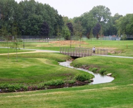
|Project summary=Ladywell Fields has been transformed from its previously characterless and formless landscape into a diverse, popular and accessible public open space. The creation of a new gravel-bedded river channel through the centre of the park has also brought about significant improvements in biodiversity. Ladywell Fields won the best-new-public-space category at London Planning Awards for its rejuvenated park in Lewisham. | |||
*Aims - natural flood risk management, land use change | |||
|Contact organisation= | |||
*Other aims and benefits - improving ecology, improving hydromorphological conditions | |||
|Contact organisation url= | |||
*Rainfall (mm) 557 | |||
|Partner organisations= | |||
*Altitude (m) 22 | |||
*Type - Implemented Working with Natural Processes measures | |||
|Name of parent multi-site project= | *Measures Flood storage areas, Reconnect rivers to floodplain | ||
|Project picture= | *Construction - Concrete removed, soil and stone banks instead and wooden pontoons for viewing | ||
|Picture description= | *Size (km2) 0.21 | ||
|Project summary= | *Date implemented - 2007 | ||
*Maintenance checks - channel erosion, sedimentation in ponds, vegetation control | |||
*Investment (£) 1,404,500 | |||
*Additional storage (m3) 15,000 | |||
*Elevation of defences (m) < 2 | |||
*Risk reduction - impacts modelled | |||
|Monitoring surveys and results=*Surveys indicating that the public’s perception of the park in terms of recreational value and safety has improved. Now 78% visitors feel safe (in comparison to 44% before the restoration), and use of the park has increased over 2 and a half times. | |||
*survey results indicating a near 100% increase in the number of species present in the park (in particular fishing birds), which are benefiting from the greater range of habitat types now present following the restoration works. | |||
|Lessons learn=Performance/Ecosystem benefits - large increase in flood water storage to maintain 1 in 100 year protection, range of environmental benefits including backwaters, riffles and pools | |||
}} | |||
{{Image gallery}} | |||
{{Case study image | |||
|File name=P8130029.JPG | |||
|Caption=Ladywell Fields fully restored, August 2008 | |||
}} | |||
{{Case study image | |||
|File name=P8140070.JPG | |||
|Caption=Created backwater, August 2008 | |||
}} | |||
{{Case study image | |||
|File name=P8140084.JPG | |||
|Caption=Created pond, August 2008 | |||
}} | }} | ||
{{ | {{Image_gallery_end}} | ||
|Subcatchment= | {{Toggle button}} | ||
{{Toggle content start}} | |||
{{Case study subcatchment | |||
|Subcatchment=Ravensbourne (Catford to Deptford) | |||
}} | }} | ||
{{Site | {{Site | ||
|Name= | |Name=Ladywell fields | ||
|WFD water body code=GB106039023270 | |||
|WFD water body name=Ravensbourne (Catford to Deptford) | |||
|Pre-project morphology=Single channel,Straight,Pool-riffle | |||
|WFD water body code= | |Reference morphology=Sinuous,Pool-riffle | ||
|Heavily modified water body=Yes | |||
|Protected species present=No | |||
|Invasive species present=No | |||
|WFD water body name= | |Dominant hydrology=Quick run-off | ||
|Dominant substrate=Bedrock,Gravel,Silt | |||
|Pre-project morphology= | |River corridor land use=Urban | ||
|Average bankfull channel width category=2 - 5 m | |||
|Reference morphology= | |Average bankfull channel depth category=0.5 - 2 m | ||
|Mn discharge=0.43 | |||
|Heavily modified water body= | |||
|Protected species present= | |||
|Invasive species present= | |||
|Dominant hydrology= | |||
|Dominant substrate= | |||
|River corridor land use= | |||
|Average bankfull channel width category= | |||
|Average bankfull channel depth category= | |||
|Mn discharge= | |||
}} | }} | ||
{{ | {{Project background | ||
|Reach length directly affected= | |Reach length directly affected=200 m | ||
|Project started=2006/06/01 | |||
|Works completed=2008/09/01 | |||
|Total1 cost=500 k€ | |||
|Project started= | |Funding sources=London Borough of Lewisham, Chester City Council, | ||
|Supplementary funding information=Part-funded through the EU’s LIFE Environment Programme | |||
|Works completed= | |||
|Total1 cost= | |||
|Funding sources= | |||
|Supplementary funding information= | |||
}} | }} | ||
{{Motivations | {{Motivations | ||
|Hydromorphological quality elements= | |Specific mitigation=Riparian development | ||
|Hydromorphological quality elements=Width & depth variation,Structure & condition of riparian zones | |||
|Other motivation=Habitat enhancement, crime prevention | |||
|Other motivation= | |||
}} | }} | ||
{{Measures | {{Measures | ||
|Bank and bed modifications measure= | |Bank and bed modifications measure=Planting,Depth variation,Removal of fencing | ||
|Floodplain / River corridor=Creation of backwaters,Creation of terraces,New footpaths | |||
|Planform / Channel pattern=Creation of meanders | |||
|Social measures=cafe built and entrances to the park improved | |||
|Floodplain / River corridor= | |Wider stakeholder / citizen engagement=Consultation | ||
|Planform / Channel pattern= | |||
|Social measures= | |||
|Wider stakeholder / citizen engagement= | |||
}} | }} | ||
{{Hydromorphological_quality_elements_header}} | {{Hydromorphological_quality_elements_header}} | ||
| Line 246: | Line 151: | ||
}} | }} | ||
{{End_table}} | {{End_table}} | ||
{{ | {{Biological quality elements header}} | ||
{{Biological quality element table row | |||
|Element=Fish | |||
|Monitored before=Yes | |||
|Monitored after=Yes | |||
|Qualitative monitoring=No | |||
|Quantitative monitoring=No | |||
|Control site used=No | |||
}} | |||
{{End_table}} | {{End_table}} | ||
{{Physico-chemical_quality_elements_header}} | {{Physico-chemical_quality_elements_header}} | ||
| Line 278: | Line 191: | ||
{{Monitoring_documents}} | {{Monitoring_documents}} | ||
{{Monitoring_documents_end}} | {{Monitoring_documents_end}} | ||
{{Additional Documents}} | {{Additional Documents}} | ||
{{Case study documents | |||
|File name=End of scheme report Ladywell Fields low res.pdf | |||
|Description=post project report | |||
}} | |||
{{Case study documents | |||
|File name=Ladywell fields.pdf | |||
|Description=RRC summary report | |||
}} | |||
{{Case study documents | |||
|File name=Ladywell Fields open house.docx | |||
|Description=architectural information | |||
}} | |||
{{Case study documents | |||
|File name=QUERCUS in Lewisham Evaluation Report.pdf | |||
|Description=evaluation report | |||
}} | |||
{{Case study documents | {{Case study documents | ||
|File name=CIWEM Living Wetlands Award - Ladywell Fields.pdf | |File name=CIWEM Living Wetlands Award - Ladywell Fields.pdf | ||
| Line 286: | Line 214: | ||
}} | }} | ||
{{Additional_Documents_end}} | {{Additional_Documents_end}} | ||
{{ | {{Additional links and references header}} | ||
{{Additional links and references | |||
|Link=www.therrc.co.uk/sites/default/files/projects/p1514.pdf | |||
|Description=RRC site description | |||
}} | |||
{{Additional links and references | |||
|Link=www.lewisham.gov.uk/mayorandcouncil/aboutthecouncil/eu-funding/Pages/QUERCUS.aspx | |||
|Description=Lewisham Council's link | |||
}} | |||
{{Additional links and references | |||
|Link=www.lewisham.gov.uk/mayorandcouncil/aboutthecouncil/eu-funding/Documents/QUERCUSProjectReportMarch2009.pdf | |||
|Description=Quercus project final report | |||
}} | |||
{{Additional links and references | |||
|Link=naturalprocesses.jbahosting.com/#12/51.4790/-0.0167 | |||
|Description=JBA case studies of natural flood risk management | |||
}} | |||
{{Additional_links_and_references_footer}} | {{Additional_links_and_references_footer}} | ||
{{Supplementary_Information | {{Supplementary_Information | ||
|Information= | |Information= | ||
}} | }} | ||
{{Case_study_upload}} | {{Case_study_upload}} | ||
{{Toggle content end}} | |||
Latest revision as of 08:57, 3 April 2017
Project overview
| Status | Complete |
|---|---|
| Project web site | http://www.quercus-project.eu/ |
| Themes | Fisheries, Flood risk management, Habitat and biodiversity, Hydromorphology, Monitoring, Social benefits, Urban |
| Country | England |
| Main contact forename | Paul |
| Main contact surname | Chapman |
| Main contact user ID | |
| Contact organisation | London Borough of Lewisham |
| Contact organisation web site | http://www.lewisham.gov.uk/ |
| Partner organisations | EU's LIFE Environment Fund, London Borough of Lewisham, Environment Agency, Building Design Partnership, Fergal Contracting |
| Parent multi-site project | |
| This is a parent project encompassing the following projects |
No |
Project summary
Ladywell Fields has been transformed from its previously characterless and formless landscape into a diverse, popular and accessible public open space. The creation of a new gravel-bedded river channel through the centre of the park has also brought about significant improvements in biodiversity. Ladywell Fields won the best-new-public-space category at London Planning Awards for its rejuvenated park in Lewisham.
- Aims - natural flood risk management, land use change
- Other aims and benefits - improving ecology, improving hydromorphological conditions
- Rainfall (mm) 557
- Altitude (m) 22
- Type - Implemented Working with Natural Processes measures
- Measures Flood storage areas, Reconnect rivers to floodplain
- Construction - Concrete removed, soil and stone banks instead and wooden pontoons for viewing
- Size (km2) 0.21
- Date implemented - 2007
- Maintenance checks - channel erosion, sedimentation in ponds, vegetation control
- Investment (£) 1,404,500
- Additional storage (m3) 15,000
- Elevation of defences (m) < 2
- Risk reduction - impacts modelled
Monitoring surveys and results
- Surveys indicating that the public’s perception of the park in terms of recreational value and safety has improved. Now 78% visitors feel safe (in comparison to 44% before the restoration), and use of the park has increased over 2 and a half times.
- survey results indicating a near 100% increase in the number of species present in the park (in particular fishing birds), which are benefiting from the greater range of habitat types now present following the restoration works.
Lessons learnt
Performance/Ecosystem benefits - large increase in flood water storage to maintain 1 in 100 year protection, range of environmental benefits including backwaters, riffles and pools
Image gallery
|
Catchment and subcatchmentSelect a catchment/subcatchment
Catchment
Subcatchment
Other case studies in this subcatchment: Broadway Fields/ Seagers Distillary, Catford Greyhound Stadium, Cornmill Gardens (QUERCUS), Ladywell Fields Phase 2, Ladywell Fields to Cornmill Gardens, Ladywell Fields toeboarding, Lewisham College weir, Linear Park, QUERCUS Ravensbourne, Ravensbourne Tescos... further results
Site
Project background
Cost for project phases
Supplementary funding informationPart-funded through the EU’s LIFE Environment Programme
Reasons for river restoration
Measures
MonitoringHydromorphological quality elements
Biological quality elements
Physico-chemical quality elements
Any other monitoring, e.g. social, economic
Monitoring documents
Additional documents and videos
Additional links and references
Supplementary InformationEdit Supplementary Information
| ||||||||||||||||||||||||||||||||||||||||||||||||||||||||||||||||||||||||||||||||||||||||||||||||||||||||||||||||||||||||||||||||||||||||||||||||||||||||||||||||||||||||||||||||||||||||||||||||||||||||||||||||||||||||||||||||||


