Case study:Wallasea (North) Managed Realignment: Difference between revisions
No edit summary |
No edit summary |
||
| (13 intermediate revisions by 4 users not shown) | |||
| Line 1: | Line 1: | ||
{{Case study status | {{Case study status | ||
|Approval status= | |Approval status=Approved | ||
}} | |||
{{Location | |||
|Location=51.59999999999999, 0.8333333000000493 | |||
}} | }} | ||
{{Project overview | {{Project overview | ||
|Status=Complete | |Status=Complete | ||
| Line 10: | Line 12: | ||
|Main contact forename=Colin | |Main contact forename=Colin | ||
|Main contact surname=Scott | |Main contact surname=Scott | ||
|Partner organisations=Defra, Environment Agency, CJT Ecology | |||
|Multi-site=No | |Multi-site=No | ||
|Project picture=Wallasea 4.JPG | |||
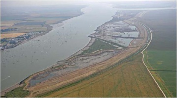
|Picture description=The site on the final day of breaching (view east) (Taken for Defra, July 2006) | |||
|Project summary=The project was promoted by Defra to create new mudflat and saltmarsh in compensation for losses of similar | |Project summary=The project was promoted by Defra to create new mudflat and saltmarsh in compensation for losses of similar | ||
coastal habitats following port developments at Lappel Bank (in the Medway Estuary) and Fagbury | coastal habitats following port developments at Lappel Bank (in the Medway Estuary) and Fagbury | ||
| Line 43: | Line 48: | ||
{{Toggle content start}} | {{Toggle content start}} | ||
{{Case study subcatchment}} | {{Case study subcatchment}} | ||
{{Site}} | {{Site | ||
{{Project background}} | |Name=North Bank of Wallasea | ||
{{Motivations}} | |WFD (national) typology=Intertidal, | ||
{{Measures}} | |Heavily modified water body=No | ||
|Protected species present=No | |||
|Invasive species present=No | |||
|River corridor land use=Arable | |||
}} | |||
{{Project background | |||
|Project started=2006/01/01 | |||
|Funding sources=Defra | |||
|Supplementary funding information=Funded mainly by Defra who commissioned an extensive site investigation/selection programme as well as all the legal, public consultation and scheme-build elements of the project. The landowner, Wallasea Farms Ltd, assisted throughout and was responsible for the submission of the Planning Application and, post-construction, will be responsible for site maintenance. | |||
}} | |||
{{Motivations | |||
|Specific mitigation=Flood risk management, | |||
|Hydromorphological quality elements=Continuity of sediment transport, | |||
|Biological quality elements=Fish, Invertebrates, Phytoplankton, | |||
|Physico-chemical quality elements=Nutrient concentrations, | |||
}} | |||
{{Measures | |||
|Management interventions=Managed realignment | |||
}} | |||
{{Hydromorphological quality elements header}} | {{Hydromorphological quality elements header}} | ||
{{End table}} | {{End table}} | ||
Latest revision as of 16:19, 13 November 2023
Project overview
| Status | Complete |
|---|---|
| Project web site | http://www.abpmer.net/omreg/ |
| Themes | Habitat and biodiversity |
| Country | England |
| Main contact forename | Colin |
| Main contact surname | Scott |
| Main contact user ID | |
| Contact organisation | |
| Contact organisation web site | |
| Partner organisations | Defra, Environment Agency, CJT Ecology |
| Parent multi-site project | |
| This is a parent project encompassing the following projects |
No |
Project summary
The project was promoted by Defra to create new mudflat and saltmarsh in compensation for losses of similar
coastal habitats following port developments at Lappel Bank (in the Medway Estuary) and Fagbury
Flats (in the Orwell Estuary). Also to enhance the coastal protection afforded the island, because
its north bank was at risk of natural and unmanaged seawall breaching.
Monitoring surveys and results
An initial five-year monitoring programme is being undertaken to describe the ecological development of the site and determine whether it meets compensation targets. This ‘site success’ monitoring includes surveys of overwintering waterbirds, benthic invertebrates, saltmarsh vegetation growth, sedimentation/erosion patterns and the settlement characteristics of the recharge area. To confirm the findings of the assessment work and test the effectiveness of the mitigation measures, this five-year programme also includes ‘impact verification’ monitoring with surveys of flow speeds, shoreline topography and channel bathymetry in the estuary.
Lessons learnt
This project has benefited from detailed investigative work and consultations that were undertaken as part of the site selection, scheme design and impact assessment work as well as for the preparation of the monitoring programmes. However, the need to find such a large site that met all the requirements was a long-term and costly exercise. There has been a full time project manager with supporting teams including representatives from statutory and non-statutory authorities and these aspects have enabled problems to be foreseen and rapidly addressed. The team approach has also allowed innovative new design elements to be identified which should provide high value at low cost (e.g. the island features in the site and a new ‘heterogenic’ borrow-dyke design).
The initial monitoring is still ongoing, and the full results from the first five-year monitoring programme have not been reported yet. However, from the interim progress reports that have been produced by ABPmer and Jacobs up to the end of 2010 (i.e. up to four years after the breaching), the following general observations have been made:
Breaches and channels: The breaches and channels through them are very stable which confirms the effectiveness of the approaches that were taken to design them.
Accretion: Within the site, sediment accretion has occurred relatively consistently and evenly due to the slow flows and stable internal creek/channel configurations. In the first year after breaching (2006 to 2007), accretion was around 10cm (of which about 50% is considered internally relocated materials and 50% externally imported sediments). In each subsequent year, the annual accretion is considered to be predominantly related to imported sediments and amounted to 3 to 5cm on average (specifically 5cm in both 2008 and 2009, and 3cm in 2010).
Invertebrates: The accretion and the relatively stable and depositional nature of the environment has helped to promote rapid benthic invertebrate colonisation of the mudflat (approx 80ha in extent). After the first, year invertebrates abundance was at 20,000 organisms/m2 and has ranged between 10,000 and 20,000 organisms/m2 in each successive year. The benthic assemblages have been dominated by large numbers of mud snail (Hydrobia ulvae) and although the patterns of organism recruitment are clearly complex and variable, there is evidence that the assemblages are maturing over time. This is indicated by the bivalve species becoming an increasingly important component over time (representing 2%, 4%, 14% and 26% of the populations in each successive year).
Birds: The bird monitoring (by CJT Ecology) shows that over the course of the four completed years of the monitoring programme the site has been supporting very good numbers of waterbirds. This was the case even from the first winter survey (2006/07) when the site supported around 7,000 waterbirds and included good numbers (i.e relatively high in a national or international context) of many key species such as shelduck, dunlin, black-tailed godwit, ringed plover and golden plover. In the following two winters the value of the site continued to improve as the abundance of waterbirds increased to around 10,000 and then 12,000. For the most recent winter (2009/10) however the overall abundance levels declined slightly. These broad trends are strongly influenced by some major inter-annual changes in the abundance of certain species which, in turn, are likely to be influenced by the weather conditions (e.g. particularly bad weather conditions were experienced in 2009/10 when compared with other years) and/or a range of other factors that influence the natural dynamics of bird populations (e.g. breeding success, timing of migrations, national population trends and inter-annual or inter-generational changes in roosting/feeding site selection). It is of note however, that the numbers of birds using the site as a roost reduced in 2009/10 while the number of birds feeding increased. This may indicate that the habitat and the relationship with migratory birds is still maturing and developing or that under adverse weather conditions the site’s value as a feeding site as opposed to a roosting site increases. Saltmarsh: Saltmarsh coverage of elevated areas of the sites (approx 25ha in extent) has occurred relatively rapidly. On average plant coverage (i.e the amount of marsh plant compared to bare mud at any given location) has rapidly increased from less than 1% in 2007 to 6% in 2008, 60% in 2009 and finally at or around 100% in 2010.
Image gallery
|
Catchment and subcatchment
Site
Project background
Cost for project phases
Supplementary funding informationFunded mainly by Defra who commissioned an extensive site investigation/selection programme as well as all the legal, public consultation and scheme-build elements of the project. The landowner, Wallasea Farms Ltd, assisted throughout and was responsible for the submission of the Planning Application and, post-construction, will be responsible for site maintenance.
Reasons for river restoration
Measures
MonitoringHydromorphological quality elements
Biological quality elements
Physico-chemical quality elements
Any other monitoring, e.g. social, economic
Monitoring documents
Additional documents and videos
Additional links and references
Supplementary InformationEdit Supplementary Information
| ||||||||||||||||||||||||||||||||||||||||||||||||||||||||||||||||||||||||||||||||||||||||||||||||||||||||||||||||||||||||||||||||||||||||||||||||||||||||||||||||||||||||


