Case study:Taming the Tame: Difference between revisions
TameValley (talk | contribs) No edit summary |
No edit summary |
||
| (5 intermediate revisions by 2 users not shown) | |||
| Line 1: | Line 1: | ||
{{Case study status | {{Case study status | ||
|Approval status= | |Approval status=Approved | ||
}} | }} | ||
{{Location | {{Location | ||
| Line 26: | Line 26: | ||
well as creating a fish refuge linkage into smiley face pool. The second phase of delivery | well as creating a fish refuge linkage into smiley face pool. The second phase of delivery | ||
which was not carried out was to create a linked backwater channel on the right bank of the | which was not carried out was to create a linked backwater channel on the right bank of the | ||
reserve. This channel will create additional and important habitat for fish and fry while also being profiled in such a way to be attractive to any remnant water vole population that exists or which may be re- introduced in the future. The island created from the work will be an important refuge for ground nesting birds. | reserve. This channel will create additional and important habitat for fish and fry while also being profiled in such a way to be attractive to any remnant water vole population that exists or which may be re- introduced in the future. The island created from the work will be an important refuge for ground nesting birds. <br> | ||
View the project video on YouTube - https://www.youtube.com/watch?time_continue=1&v=1R95ViXTC_0 | |||
|Monitoring surveys and results=WFD baseline data | |Monitoring surveys and results=WFD baseline data | ||
River profile surveys | River profile surveys | ||
| Line 39: | Line 41: | ||
{{Toggle button}} | {{Toggle button}} | ||
{{Toggle content start}} | {{Toggle content start}} | ||
{{Case study subcatchment}} | {{Case study subcatchment | ||
|Subcatchment=River Tame from R Blythe to River Anker | |||
}} | |||
{{Site}} | {{Site}} | ||
{{Project background}} | {{Project background | ||
{{Motivations}} | |Project started=2005 | ||
{{Measures}} | }} | ||
{{Motivations | |||
|Biological quality elements=Fish, | |||
}} | |||
{{Measures | |||
|Bank and bed modifications measure=Channel reprofiling, | |||
|Planform / Channel pattern=Habitat creation, Habitat restoration, Creation of an island, | |||
}} | |||
{{Hydromorphological quality elements header}} | {{Hydromorphological quality elements header}} | ||
{{End table}} | {{End table}} | ||
Latest revision as of 09:36, 4 January 2019
Project overview
| Status | Complete |
|---|---|
| Project web site | http://http://www.tamevalleywetlands.co.uk/ |
| Themes | Environmental flows and water resources, Fisheries, Habitat and biodiversity, Water quality, Urban |
| Country | England |
| Main contact forename | Tracey |
| Main contact surname | Doherty |
| Main contact user ID | User:TameValley |
| Contact organisation | Warwickshire Wildlife Trust |
| Contact organisation web site | http://http://www.tamevalleywetlands.co.uk/ |
| Partner organisations | Environment Agency, Tamworth Borough Council, Tameside Wildlife Conservation Group, Staffordshire Wildlife Trust |
| Parent multi-site project | |
| This is a parent project encompassing the following projects |
No |
Project summary
To create a backwater channel linked to the River Tame to create an important habitat and
refuge for fish.
The project aims to complete river restoration aspirations at Tameside Local Nature Reserve
in Tamworth. This follows the original project started in 2009 by the EA, Tamworth BC and
Staffordshire Wildlife Trust which pulled back bank, created 10 scrapes and small ponds as
well as creating a fish refuge linkage into smiley face pool. The second phase of delivery
which was not carried out was to create a linked backwater channel on the right bank of the
reserve. This channel will create additional and important habitat for fish and fry while also being profiled in such a way to be attractive to any remnant water vole population that exists or which may be re- introduced in the future. The island created from the work will be an important refuge for ground nesting birds.
View the project video on YouTube - https://www.youtube.com/watch?time_continue=1&v=1R95ViXTC_0
Monitoring surveys and results
WFD baseline data
River profile surveys
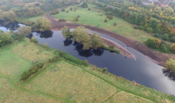
Drone images from above before and after - aerial
Fixed point photos before and after land
Fish survey in new channel and invertebrate surveys to be carried out 2018 to see what is in the channel
Lessons learnt
Image gallery
|
Catchment and subcatchmentSelect a catchment/subcatchment
Catchment
Subcatchment
Other case studies in this subcatchment: Prologis Midpoint Park river restoration scheme
Site
Project background
Cost for project phases
Reasons for river restoration
Measures
MonitoringHydromorphological quality elements
Biological quality elements
Physico-chemical quality elements
Any other monitoring, e.g. social, economic
Monitoring documents
Additional documents and videos
Additional links and references
Supplementary InformationEdit Supplementary Information
| ||||||||||||||||||||||||||||||||||||||||||||||||||||||||||||||||||||||||||||||||||||||||||||||||||||||||||||||||||||||||||||||||||||||||||||||||||||||||||||||||||||||||||||||||||||||||||||||||||||||||

