Case study:Markway Stream Restoration: Difference between revisions
Jump to navigation
Jump to search
(Created page with "{{Case study status |Approval status=Draft }} {{Location |Location=50.83335899971188, -1.6462293779477477 }} {{Project overview |Project title=Markway Stream Restoration |Stat...") |
No edit summary |
||
| (12 intermediate revisions by 4 users not shown) | |||
| Line 1: | Line 1: | ||
{{Case study status | {{Case study status | ||
|Approval status= | |Approval status=Approved | ||
}} | }} | ||
{{Location | {{Location | ||
| Line 6: | Line 6: | ||
}} | }} | ||
{{Project overview | {{Project overview | ||
|Status=Complete | |Status=Complete | ||
|Project web site url=www.newforestlife.org.uk/life3/life3index.htm | |||
|Themes=Environmental flows and water resources, Hydromorphology, Land use management - forestry | |Themes=Environmental flows and water resources, Hydromorphology, Land use management - forestry | ||
|Country=England | |Country=England | ||
| Line 14: | Line 14: | ||
|Contact organisation=Hampshire County Council | |Contact organisation=Hampshire County Council | ||
|Contact organisation url=www.hants.gov.uk/ | |Contact organisation url=www.hants.gov.uk/ | ||
|Partner organisations=English Nature, Environment Agency, Forestry Commission, National Trust, RSPB | |||
|Name of parent multi-site project=Case_study:New Forest LIFE project | |||
|Multi-site=No | |Multi-site=No | ||
| | |Project picture=Markway Stream.jpg | ||
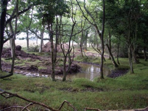
|Picture description=Restored meander | |||
|Project summary=This site is a part of New Forest LIFE project. The aim of the project at this site was to develop a restoration scheme for the river that would balance the Commoner’s aspirations for floodplain grazing with the conservation objections of the New Forest SAC. Works contained the excavation and reinstatement of former meandering channel, installation of a clay plug 20-30cm higher than the surrounding floodplain and removal of weed from a 350m length of channel. | |||
}} | }} | ||
{{Image gallery}} | {{Image gallery}} | ||
| Line 21: | Line 25: | ||
{{Toggle button}} | {{Toggle button}} | ||
{{Toggle content start}} | {{Toggle content start}} | ||
{{Case study subcatchment}} | {{Case study subcatchment | ||
{{Site}} | |Subcatchment=Ober Water | ||
{{Project background}} | }} | ||
{{Motivations}} | {{Site | ||
{{Measures}} | |Name=Markway Stream | ||
|WFD water body code=GB107042011360 | |||
|WFD water body name=Ober Water | |||
|Heavily modified water body=Yes | |||
|Protected species present=No | |||
|Invasive species present=No | |||
}} | |||
{{Project background | |||
|Reach length directly affected=1300 | |||
|Project started=2002/07/01 | |||
|Project completed=2006/12/31 | |||
|Total cost category=10 - 50 k€ | |||
|Funding sources=EU LIFE Programme, | |||
}} | |||
{{Motivations | |||
|Hydromorphological quality elements=Width & depth variation, Channel pattern/planform, | |||
}} | |||
{{Measures | |||
|Bank and bed modifications measure=Excavation of bedrock, | |||
|Planform / Channel pattern=Creation of meanders, | |||
|Other technical measure=Installation of a clay plug | |||
}} | |||
{{Hydromorphological quality elements header}} | {{Hydromorphological quality elements header}} | ||
{{End table}} | {{End table}} | ||
| Line 39: | Line 64: | ||
{{Additional Documents end}} | {{Additional Documents end}} | ||
{{Additional links and references header}} | {{Additional links and references header}} | ||
{{Additional links and references | |||
|Link=ec.europa.eu/environment/life/project/Projects/index.cfm?fuseaction=home.showFile&rep=file&fil=LIFE02_NAT_UK_008544_AfterLIFE.pdf | |||
|Description=After LIFE conservation plan | |||
}} | |||
{{Additional links and references | |||
|Link=www.newforestlife.org.uk/life3/life3index.htm | |||
|Description=New Forest LIFE 3 web page | |||
}} | |||
{{Additional links and references | |||
|Link=ec.europa.eu/environment/life/project/Projects/index.cfm?fuseaction=home.createPage&s_ref=LIFE02%20NAT/UK/008544&area=1&yr=2002&n_proj_id=1976&cfid=423407&cftoken=1adf75e7742a0a31-858CC2AB-CCBA-042D-07FCA090D1A64E01&mode=print&menu=false | |||
|Description=New Forest on EU LIFE programme | |||
}} | |||
{{Additional links and references footer}} | {{Additional links and references footer}} | ||
{{Supplementary Information}} | {{Supplementary Information}} | ||
{{Toggle content end}} | {{Toggle content end}} | ||
Latest revision as of 16:47, 2 January 2019
Location: 50° 50' 0.09" N, 1° 38' 46.43" W
Left click to look around in the map, and use the wheel of your mouse to zoom in and out.
Project overview
| Status | Complete |
|---|---|
| Project web site | http://www.newforestlife.org.uk/life3/life3index.htm |
| Themes | Environmental flows and water resources, Hydromorphology, Land use management - forestry |
| Country | England |
| Main contact forename | Bryan |
| Main contact surname | Boult |
| Main contact user ID | |
| Contact organisation | Hampshire County Council |
| Contact organisation web site | http://www.hants.gov.uk/ |
| Partner organisations | English Nature, Environment Agency, Forestry Commission, National Trust, RSPB |
| Parent multi-site project | |
| This is a parent project encompassing the following projects |
No |
Project summary
Edit project overview to modify the project summary.
This site is a part of New Forest LIFE project. The aim of the project at this site was to develop a restoration scheme for the river that would balance the Commoner’s aspirations for floodplain grazing with the conservation objections of the New Forest SAC. Works contained the excavation and reinstatement of former meandering channel, installation of a clay plug 20-30cm higher than the surrounding floodplain and removal of weed from a 350m length of channel.
Monitoring surveys and results
This case study hasn’t got any Monitoring survey and results, you can add some by editing the project overview.
Lessons learnt
This case study hasn’t got any lessons learnt, you can add some by editing the project overview.
Image gallery
|
Catchment and subcatchmentSelect a catchment/subcatchment
Catchment
Subcatchment
Site
Project background
Cost for project phases
Reasons for river restoration
Measures
MonitoringHydromorphological quality elements
Biological quality elements
Physico-chemical quality elements
Any other monitoring, e.g. social, economic
Monitoring documents
Additional documents and videos
Additional links and referencesSupplementary InformationEdit Supplementary Information
| ||||||||||||||||||||||||||||||||||||||||||||||||||||||||||||||||||||||||||||||||||||||||||||||||||||||||||||||||||||||||||||||||||||||||||||||||||||||||||||||||||||||||||||||||||||||||||||||||||||||

