Case study:Sutcliffe Park: Difference between revisions
No edit summary |
No edit summary |
||
| (8 intermediate revisions by 3 users not shown) | |||
| Line 7: | Line 7: | ||
{{Project overview | {{Project overview | ||
|Status=Complete | |Status=Complete | ||
|Themes=Flood risk management, Habitat and biodiversity | |Themes=Flood risk management, Habitat and biodiversity, Social benefits, Urban | ||
|Country=England | |Country=England | ||
|Main contact forename=Toni | |Main contact forename=Toni | ||
| Line 28: | Line 28: | ||
It’s making a major contribution to the quality of life for local residents. Natural environments encourage regular physical activity, reduce the risk of serious diseases and improve mental well-being. | It’s making a major contribution to the quality of life for local residents. Natural environments encourage regular physical activity, reduce the risk of serious diseases and improve mental well-being. | ||
|Monitoring surveys and results=Surveys have shown that park visits have increased significantly. And people who used the park before, are now staying longer. One in four only started visiting the park after the improvements. | |||
*The number of park visits increased by 73% | |||
*People stay longer, on average 47 minutes per visit compared to 34 minutes | |||
*Total time spent in the park per person per month increased by more than 3.5 hours | |||
*28% of people surveyed started visiting only recently, due to the improvements | |||
*More people visited more often, stayed longer and were more likely to visit to exercise and for health | |||
*Analysis showed that visitors’ self esteem increased the longer they had spent exercising in the natural environment. | |||
*Local green spaces are an important health resource for surrounding communities. | |||
'''83% of visitors feel differently in the park now the River Quaggy runs though it, because of increased biodiversity, better opportunities for recreation, and the peacefulness and relaxation of being near water. | |||
Before restoration, Sutcliffe Park was a flat green area, lacking biodiversity, with the Quaggy River running in an underground culvert. Interesting bird species have now been seen in the new wetlands including heron, little ringed plover, common sandpiper, wagtails including yellow and grey, with linnets and goldfinches feeding on the groundsel. Equally as exciting are the numbers of dragonflies and damselflies that can be seen around the lake, in the wetland pools and along the Quaggy River. Emperor dragonflies (Europe's largest species) have colonised the park and have been seen ovipositing (egg laying) in the water bodies and the river channel soon after completion of the scheme. Large numbers of the attractive red common darter, black tailed skimmer, common blue and blue tailed damselflies can also be seen using the marginal plants in summer time. Water figwort, celery leaved buttercup and gypsywort are all valuable species which have self seeded along the river channel. Bats have also been detected along the river corridor. | |||
The re-naturalisation of the river for flood management and re-landscaping work has lead to the site being recently designated as a local nature reserve. | |||
|Lessons learn=The levels should have been set so that no lowflow runs through the culvert surrounding the park. However, some flow does still go through the culvert. This means that the channel within the park can suffer from very low flows. | |||
}} | }} | ||
{{Image gallery}} | |||
{{Case study image | |||
|File name=Quaggy.jpg | |||
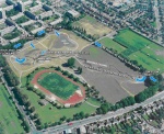
|Caption=Sutcliffe Park Flood defence aspects | |||
}} | |||
{{Case study image | |||
|File name=Sutcliffe park 2.JPG | |||
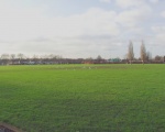
|Caption=Sutcliffe park before | |||
}} | |||
{{Case study image | |||
|File name=Sutcliffe park after.JPG | |||
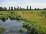
|Caption=Sutcliffe park after | |||
}} | |||
{{Image gallery end}} | |||
{{Toggle button}} | |||
{{Toggle content start}} | |||
{{Case study subcatchment | {{Case study subcatchment | ||
|Subcatchment=Quaggy | |Subcatchment=Quaggy | ||
| Line 62: | Line 94: | ||
}} | }} | ||
{{Measures | {{Measures | ||
|Bank and bed modifications measure=Planting of native species | |Bank and bed modifications measure=Planting of native species, | ||
|Floodplain / River corridor=Creation of | |Floodplain / River corridor=Creation of pond, Creation of a lake, Wildflower meadows | ||
|Planform / Channel pattern= | |Planform / Channel pattern=Creation of new channel, Deculverting, Meandering channel, | ||
|Other technical measure= | |Other technical measure=Boardwalks, Paths, Seating areas, Viewing points | ||
|Wider stakeholder / citizen engagement= | |Wider stakeholder / citizen engagement=Community engagement, | ||
}} | }} | ||
{{Hydromorphological quality elements header}} | {{Hydromorphological quality elements header}} | ||
| Line 192: | Line 224: | ||
}} | }} | ||
{{Monitoring documents end}} | {{Monitoring documents end}} | ||
{{Additional Documents}} | {{Additional Documents}} | ||
{{Case study documents | {{Case study documents | ||
| Line 234: | Line 252: | ||
}} | }} | ||
{{Toggle content end}} | |||
Latest revision as of 16:30, 2 January 2019
Project overview
| Status | Complete |
|---|---|
| Project web site | |
| Themes | Flood risk management, Habitat and biodiversity, Social benefits, Urban |
| Country | England |
| Main contact forename | Toni |
| Main contact surname | Scarr |
| Main contact user ID | User:Ascarr |
| Contact organisation | Environment Agency |
| Contact organisation web site | http://www.environment-agency.gov.uk |
| Partner organisations | Quaggy Waterways Action Group |
| Parent multi-site project | |
| This is a parent project encompassing the following projects |
No |
Project summary
Before the restoration project, the Quaggy at Sutcliffe Park was a forgotten river. It flowed underground through a concrete channel, unnoticed and providing little habitat for wildlife.
By bringing the Quaggy out of its culvert, a meandering river has been reborn. Now, the river can overflow into the park using it as a flood storage area.
And at other times, the park is there for local communities to enjoy. A network of pathways and viewing points criss-cross the park. Within the wetland areas, there are wooden boardwalks making the area more accessible for prams and wheelchairs. It is a habitat for a huge variety of plants and animals, and features wildflower meadows, wetland areas, reed beds, lakes and ponds.
The river is now a place where wildlife can thrive - from emperor dragonflies and wetland birds, to amphibians and butterflies. Several protected species have now made it their home, including the reed warbler and little grebe. The park has quickly become an important area of natural beauty and a recreational site for the local community.
It’s making a major contribution to the quality of life for local residents. Natural environments encourage regular physical activity, reduce the risk of serious diseases and improve mental well-being.
Monitoring surveys and results
Surveys have shown that park visits have increased significantly. And people who used the park before, are now staying longer. One in four only started visiting the park after the improvements.
- The number of park visits increased by 73%
- People stay longer, on average 47 minutes per visit compared to 34 minutes
- Total time spent in the park per person per month increased by more than 3.5 hours
- 28% of people surveyed started visiting only recently, due to the improvements
- More people visited more often, stayed longer and were more likely to visit to exercise and for health
- Analysis showed that visitors’ self esteem increased the longer they had spent exercising in the natural environment.
- Local green spaces are an important health resource for surrounding communities.
83% of visitors feel differently in the park now the River Quaggy runs though it, because of increased biodiversity, better opportunities for recreation, and the peacefulness and relaxation of being near water.
Before restoration, Sutcliffe Park was a flat green area, lacking biodiversity, with the Quaggy River running in an underground culvert. Interesting bird species have now been seen in the new wetlands including heron, little ringed plover, common sandpiper, wagtails including yellow and grey, with linnets and goldfinches feeding on the groundsel. Equally as exciting are the numbers of dragonflies and damselflies that can be seen around the lake, in the wetland pools and along the Quaggy River. Emperor dragonflies (Europe's largest species) have colonised the park and have been seen ovipositing (egg laying) in the water bodies and the river channel soon after completion of the scheme. Large numbers of the attractive red common darter, black tailed skimmer, common blue and blue tailed damselflies can also be seen using the marginal plants in summer time. Water figwort, celery leaved buttercup and gypsywort are all valuable species which have self seeded along the river channel. Bats have also been detected along the river corridor.
The re-naturalisation of the river for flood management and re-landscaping work has lead to the site being recently designated as a local nature reserve.
Lessons learnt
The levels should have been set so that no lowflow runs through the culvert surrounding the park. However, some flow does still go through the culvert. This means that the channel within the park can suffer from very low flows.
Image gallery
|
Catchment and subcatchmentSelect a catchment/subcatchment
Catchment
Subcatchment
Other case studies in this subcatchment: Colfes School, Lidl, Manor House Gardens, Manor House Gardens Gauging Station, Manor Park, Mottingham Farm, Quaggy Flood Alleviation Scheme, Quaggy channel improvements, River Quaggy- Chinbrook meadows, Sydenham Cottages Nature Reserve
Site
Project background
Cost for project phases
Reasons for river restoration
Measures
MonitoringHydromorphological quality elements
Biological quality elements
Physico-chemical quality elements
Any other monitoring, e.g. social, economic
Monitoring documents
Additional documents and videos
Additional links and references
Supplementary InformationEdit Supplementary Information construction The works were designed to alleviate flooding in the Lewisham area. The flood detention area was constructed on the Quaggy River. The location of the detention area is approximately 3km east of Lewisham, in the London Borough of Greenwich, in Sutcliffe Park, formerly eight football pitches. The construction includes a 2.5m high x 480m long earth embankment, which surrounds Sutcliffe Park. The embankment is 2.5m high at its highest point to the west side of the site and at existing ground level to the east. The embankment retains floodwaters within the reservoir basin that has been excavated. The culvert carrying the river follows two sides of the park and is to remain. The low flow inlet control structure was formed through cutting slots into the side of the culvert and a reinforced concrete channel to direct the flow into the park. A few metres downstream of the low flow inlet is a 0.5m high weir to direct the majority of the flow through the park. The high flow inlet also has slots cut into the side of the culvert and a concrete slab in front to prevent erosion. Just downstream of the high flow inlet a flume has been constructed within the culvert to constrict the flow. The spillway also has slots in the side of the culvert and the landform is at a lower level to allow the water back into the culvert at this location. The outlet structure is constructed from reinforced concrete and has a plastic pipe connecting the flow from the park back into the culvert. The low flow inlet and outlet structures have penstocks within them to control the water movements. description The plans for the river restoration programme date back as far as 1989, although the work did not commence until April 2003 and the park was re-opened in June 2004. Prior to the restoration work, Sutcliffe Park was described as a flat area of open greenspace with a lack of biodiversity, with the mown grassland primarily used for sporting activities. It consisted of 11 football pitches and an athletics track, with only the track remaining since the enhancements. It is about 1.6 km in circumference with numerous entrances and exits. Since the 1930s the River Quaggy has ran underground along a concrete channel, referred to as a “culvert”, around two sides of the park. The park has now been re-landscaped to create a naturalised river, which flows through the park at surface level. The culvert still exists, but now overflows into the park when it is full. The design of the park allows a controlled flood to occur which covers the lower lying sections of the park, where the river feeds into the lake. An important influence of this scheme is the presence of a local action group called “The Friends of The Quaggy / QWAG”. Community participation and involvement of local residents played a key role in identifying and campaigning the viable alternative to river channelisation. The restored park is more of a wetland environment as it provides a variety of habitats for local wildlife, including reed beds and a shallow lake. The park is now rich in biodiversity and users have commented on the “joy of watching nature doing its own thing”. It has a more formal feel at one end due to its wrought iron railings and traditional benches, whereas the opposing end is more natural with bridges, boardwalks and outdoor furniture. There is a circular seating area which acts as a meeting place for local residents and school children to convene. The abundance of flora and fauna allows visitors an opportunity to learn about environmental matters. Users of Sutcliffe Park include predominantly dog walkers and joggers. It is also used by family groups to feed the ducks and as a thoroughfare to bus stops. The establishment of a “Friends of Sutcliffe Park” is currently emerging and a recommendation for the local walking group “Green chain” to include the park within their routes is being addressed.
| ||||||||||||||||||||||||||||||||||||||||||||||||||||||||||||||||||||||||||||||||||||||||||||||||||||||||||||||||||||||||||||||||||||||||||||||||||||||||||||||||||||||||||||||||||||||||||||||||||||||||||||||||||||||||||||||||||||||||||||||||||||||||||||||||||||||||||||||||||||||||||||||


