Case study:River Alt at Knowsley: Difference between revisions
No edit summary |
No edit summary |
||
| (13 intermediate revisions by 4 users not shown) | |||
| Line 1: | Line 1: | ||
{{Case study status | {{Case study status | ||
|Approval status= | |Approval status=Approved | ||
}} | }} | ||
{{Location | {{Location | ||
| Line 23: | Line 23: | ||
Water quality appears to have improved with the number and density of pollution sensitive invertebrates increasing since the works were carried out. | Water quality appears to have improved with the number and density of pollution sensitive invertebrates increasing since the works were carried out. | ||
Anecdotal evidence suggests that people are happy with the scheme. Knowsley MBC is undertaking further works to open up the riparian corridor and is currently installing a cycle path. | Anecdotal evidence suggests that people are happy with the scheme. Knowsley MBC is undertaking further works to open up the riparian corridor and is currently installing a cycle path. | ||
Community involvement - Consultation with local authorities, community groups and local schools took place during the design and construction phases. | |||
}} | |||
{{Image gallery}} | |||
{{Case study image | |||
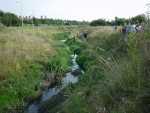
|File name=Prior to works.jpg | |||
|Caption=River Alt prior to works | |||
}} | |||
{{Case study image | |||
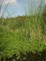
|File name=Vegetated channel.jpg | |||
|Caption=Vegetated channel threads | |||
}} | |||
{{Case study image | |||
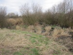
|File name=Vegetation structure.jpg | |||
|Caption=Diverse vegetation structure | |||
}} | |||
{{Case study image | |||
|File name=Excavated flooplain area.jpg | |||
|Caption=Newly excavated floodplain area | |||
}} | |||
{{Case study image | |||
|File name=2012Nov23 Woolfall H Reedbed area cropped.jpg | |||
|Caption=Floodplain area - 2012 | |||
}} | |||
{{Case study image | |||
|File name=March 2012 comparative photo.JPG | |||
|Caption=One of choked braided side channels - 2012 | |||
}} | |||
{{Case study image | |||
|File name=Sept 2012.jpg | |||
|Caption=Issues with urban litter evident - 2012 | |||
}} | |||
{{Image gallery end}} | |||
{{Toggle button}} | |||
{{Toggle content start}} | |||
{{Case study subcatchment | |||
|Subcatchment=River Alt | |||
}} | }} | ||
{{Site | {{Site | ||
|Name=River Alt, Knowsley | |Name=River Alt, Knowsley | ||
| Line 49: | Line 85: | ||
}} | }} | ||
{{Measures | {{Measures | ||
|Bank and bed modifications measure= | |Bank and bed modifications measure=Embankment lowering, | ||
|Floodplain / River corridor=Floodplain | |Floodplain / River corridor=Floodplain reconnection, Protect/restore riparian zone, Riparian planting, | ||
|Planform / Channel pattern=Creation of braided channel, | |Planform / Channel pattern=Creation of braided channel, Channel naturalisation, | ||
|Management interventions=Tree management works and re-opening of choked side channels is planned as part of 'Knowsley 2020' project. The site would have benefited from a long term tailored management plan. | |Management interventions=Tree management works and re-opening of choked side channels is planned as part of 'Knowsley 2020' project. The site would have benefited from a long term tailored management plan. | ||
|Social measures= | |Social measures=Improved public access, Engagement with schools, | ||
|Wider stakeholder / citizen engagement= | |Wider stakeholder / citizen engagement=Community engagement, | ||
}} | }} | ||
{{Hydromorphological quality elements header}} | {{Hydromorphological quality elements header}} | ||
{{End table}} | {{End table}} | ||
{{Biological quality elements header}} | {{Biological quality elements header}} | ||
{{Biological quality element table row | |||
|Element=Invertebrates | |||
|Monitored before=No | |||
|Monitored after=Yes | |||
|Qualitative monitoring=No | |||
|Quantitative monitoring=Yes | |||
|Control site used=No | |||
|Result=Improvement | |||
}} | |||
{{End table}} | {{End table}} | ||
{{Physico-chemical quality elements header}} | {{Physico-chemical quality elements header}} | ||
{{Physico-chemical quality element table row | |||
|Monitored before=Yes | |||
|Monitored after=Yes | |||
|Qualitative monitoring=No | |||
|Quantitative monitoring=No | |||
|Control site used=No | |||
|Result=Improvement | |||
}} | |||
{{End table}} | {{End table}} | ||
{{Other responses header}} | {{Other responses header}} | ||
{{Other response table row | |||
|Element=Public perceptions | |||
|Monitored before=No | |||
|Monitored after=Yes | |||
|Qualitative monitoring=Yes | |||
|Quantitative monitoring=No | |||
|Control site used=No | |||
|Result=Awaiting results | |||
}} | |||
{{End table}} | {{End table}} | ||
{{Monitoring documents}} | {{Monitoring documents}} | ||
{{Monitoring documents end}} | {{Monitoring documents end}} | ||
{{Additional Documents}} | {{Additional Documents}} | ||
{{Additional Documents end}} | {{Additional Documents end}} | ||
{{Additional links and references header}} | {{Additional links and references header}} | ||
{{Additional links and references | |||
|Link=www.therrc.co.uk/pdf/manual/MAN_3_4.pdf | |||
|Description=RRC Manual of River Restoration Techniques entry | |||
}} | |||
{{Additional links and references footer}} | {{Additional links and references footer}} | ||
{{Supplementary Information}} | {{Supplementary Information}} | ||
{{Toggle content end}} | |||
Latest revision as of 15:53, 2 January 2019
Project overview
| Status | Complete |
|---|---|
| Project web site | |
| Themes | Fisheries, Flood risk management, Habitat and biodiversity, Water quality |
| Country | England |
| Main contact forename | Sue |
| Main contact surname | Slamon |
| Main contact user ID | |
| Contact organisation | Environment Agency |
| Contact organisation web site | http://www.environment-agency.gov.uk/ |
| Partner organisations | |
| Parent multi-site project | |
| This is a parent project encompassing the following projects |
No |
Project summary
The Alt is a small, low energy urban river which had been historically re-sectioned, straightened and over deepened. The river flows beside a road and was constrained within a trapezoidal channel. Improved water quality had seen fish return to parts of the river but further improvements to the riverine habitat were desired.
Consultation with local authorities, community groups and local schools took place during the design and construction phases. Options were limited by planning permissions on parts of the site and the existence of a wildflower meadow. Improving public access to the river was a very important element of the scheme.
The 1.5m, 30 degree banks were excavated back on either side of the existing course and up to 30m width of 'floodplain' was created. This comprises a mix of a main and braided channels separated by marginal berms. The new course was approximately 25% larger and deeper than the braided channels to encourage the majority of low flows along this route.
Initial earthworks have delivered access and recreation improvements along this stretch of the Alt. Reedbed habitat has established reinstating a locally rare habitat. However, this has also has some negative impacts in that biodiversity has been limited by reedbed monoculture and encroachment of the reedbed has reduced velocities increasing siltation and reducing flow variation as a result.
Minimal management has been undertaken since the project work and as a result the site has become overgrown with vegetation and some of the braided side channels have become choked. Tree work is underway as is work to re-open the braided channels (part of Knowsley 2020 Project). The project would have benefited from a tailored long term management plan.
Water quality appears to have improved with the number and density of pollution sensitive invertebrates increasing since the works were carried out.
Anecdotal evidence suggests that people are happy with the scheme. Knowsley MBC is undertaking further works to open up the riparian corridor and is currently installing a cycle path.
Community involvement - Consultation with local authorities, community groups and local schools took place during the design and construction phases.
Monitoring surveys and results
Lessons learnt
Image gallery
|
Catchment and subcatchmentSelect a catchment/subcatchment
Catchment
Subcatchment
Other case studies in this subcatchment: Fazakerley Brook Wetland, Melling Brook
Site
Project background
Cost for project phases
Reasons for river restoration
Measures
MonitoringHydromorphological quality elements
Biological quality elements
Physico-chemical quality elements
Any other monitoring, e.g. social, economic
Monitoring documents
Additional documents and videos
Additional links and references
Supplementary InformationEdit Supplementary Information
| |||||||||||||||||||||||||||||||||||||||||||||||||||||||||||||||||||||||||||||||||||||||||||||||||||||||||||||||||||||||||||||||||||||||||||||||||||||||||||||||||||||||||||||||||||||||||||||||||||||||||||||||||||||||||||||||


