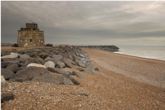
Case study:Pevensey Sea Defences: Difference between revisions
No edit summary |
No edit summary |
||
| (3 intermediate revisions by the same user not shown) | |||
| Line 1: | Line 1: | ||
{{Case study status | {{Case study status | ||
|Approval status= | |Approval status=Approved | ||
}} | }} | ||
{{Location | {{Location | ||
| Line 34: | Line 34: | ||
{{Case study subcatchment}} | {{Case study subcatchment}} | ||
{{Site}} | {{Site}} | ||
{{Project background}} | {{Project background | ||
{{Motivations}} | |Project started=2000 | ||
{{Measures}} | |Total1 cost=£1m | ||
|Funding sources=Public-private partnership, Partnership contributions, | |||
}} | |||
{{Motivations | |||
|Specific mitigation=Flood and coastal erosion protection, | |||
}} | |||
{{Measures | |||
|Other technical measure=Beach nourishment | |||
}} | |||
{{Hydromorphological quality elements header}} | {{Hydromorphological quality elements header}} | ||
{{End table}} | {{End table}} | ||
Latest revision as of 16:03, 8 November 2018
Project overview
| Status | Complete |
|---|---|
| Project web site | http://www.therrc.co.uk/sites/default/files/projects/61_pevensey.pdf |
| Themes | Economic aspects, Flood risk management, Social benefits |
| Country | England |
| Main contact forename | Ian |
| Main contact surname | Thomas |
| Main contact user ID | |
| Contact organisation | Pevensey Coastal Defence Ltd |
| Contact organisation web site | http://pevensey-bay.co.uk |
| Partner organisations | Environment Agency, Boskalis Westminster Ltd, Balfour Beatty, Mackley |
| Parent multi-site project | |
| This is a parent project encompassing the following projects |
No |
Project summary
The sea defences at Pevensey Bay in East Sussex (Map 1) are managed by Pevensey Coastal Defence Ltd (PCD) under a 25 year (2000 to 2025) public–private partnership (PPP) contract. The scheme is funded day to day by PCD. However, the contract is flexible enough to accommodate change. The sediment deficit of 30,000m3 on the Pevensey frontage is replenished in 2 ways:
• Recharge from offshore – as dredged material from Owers Bank (near Littlehampton) is rainbowed onto the beach at the western end of the frontage.
• Bypassing of material accumulated against the southern harbour arm around Sovereign Harbour (Photo 1) by road lorries – some 4,000–25,000m3 are moved per year with an annual average in recent years of 9,000m3. Under the PPP contract, PCD expects to receive 5,000m3 of material and pays for any over this amount.
In addition:
• Dredged material from the navigation channel adjacent to the harbour entrance is deposited below low water springs (this material is finer than material taken from the beach). This dredging is done by harbour owners, Premier Marinas, and not by PCD. PCD works with Premier Marinas to try and ensure suitable sediments are beneficially reused. About 40,000m3 have been reused in the last 2 years rather than being dumped at sea.
• Recycling from the eastern end of the frontage westwards – this is done piecemeal, moving material various distances but rarely the full length of the frontage. Recycling volumes average about 100,000m3 annually.
Other flood risk management measures carried out by PCD on the frontage are beach profiling, constructing/maintaining retaining walls to hold beach material in place and maintaining around 7 groynes. The remaining 150 groynes on the frontage are not being maintained and had already deteriorated to a poor standard before the project started. The hybrid scheme improves responsiveness, flexibility and sustainability. The South West Beach at Sovereign Harbour is a highly volatile section of coast and sediment can build up to a point where it should be removed in days. PCD is best placed to initiate bypassing works at short notice. Bypassed material is only available between October and March, when dredgers generally find conditions are too rough for them to operate. Recharge and bypassing both represent Working with Natural Processes (WWNP).
Monitoring surveys and results
Lessons learnt
Image gallery
|
Catchment and subcatchment
Site
Project background
Cost for project phases
Reasons for river restoration
Measures
MonitoringHydromorphological quality elements
Biological quality elements
Physico-chemical quality elements
Any other monitoring, e.g. social, economic
Monitoring documents
Additional documents and videos
Additional links and references
Supplementary InformationEdit Supplementary Information
| ||||||||||||||||||||||||||||||||||||||||||||||||||||||||||||||||||||||||||||||||||||||||||||||||||||||||||||||||||||||||||||||||||||||||||||||||||||||||||||||||||||||||||||||||||

