Case study:Evenlode Catchment Project: Difference between revisions
No edit summary |
No edit summary |
||
| (4 intermediate revisions by the same user not shown) | |||
| Line 1: | Line 1: | ||
{{Case study status | {{Case study status | ||
|Approval status= | |Approval status=Approved | ||
}} | }} | ||
{{Location | {{Location | ||
| Line 29: | Line 29: | ||
{{Toggle content start}} | {{Toggle content start}} | ||
{{Case study subcatchment}} | {{Case study subcatchment}} | ||
{{Site}} | {{Site | ||
{{Project background}} | |Name=Evenlode | ||
{{Motivations}} | |Heavily modified water body=No | ||
{{Measures}} | |Protected species present=No | ||
|Invasive species present=No | |||
}} | |||
{{Project background | |||
|Project started=2016 | |||
|Total1 cost=£480k | |||
|Funding sources=Thames RFCC local levy, Flood and Coastal Risk Management, Environment Agency Grant in Aid, Water Framework Directive, Parish Council, Cotswold River Trust, Landowner, | |||
}} | |||
{{Motivations | |||
|Specific mitigation=Flood risk management, | |||
}} | |||
{{Measures | |||
|Other technical measure=Runoff pathway management, | |||
}} | |||
{{Hydromorphological quality elements header}} | {{Hydromorphological quality elements header}} | ||
{{End table}} | {{End table}} | ||
Latest revision as of 13:32, 8 November 2018
Project overview
| Status | In progress |
|---|---|
| Project web site | http://www.therrc.co.uk/sites/default/files/projects/43_evenlode.pdf |
| Themes | Flood risk management, Habitat and biodiversity, Hydromorphology, Land use management - agriculture, Land use management - forestry, Monitoring, Water quality |
| Country | England |
| Main contact forename | Joanne |
| Main contact surname | Old |
| Main contact user ID | |
| Contact organisation | Environment Agency |
| Contact organisation web site | http://www.gov.uk/government/organisations/environment-agency |
| Partner organisations | Wild Oxfordshire, West Oxfordshire District Council, Windrush AEC Ltd, Wychwood Project, Thames Water, Cotswolds Rivers Trust, Berks, Bucks and Oxon Wildlife Trust, Forestry Commission, Sylva Foundation, Centre for Ecology & Hydrology, Cotswolds Area of Outstanding Natural Beauty, Natural England, Upper Thames Fisheries Consultative, Combe Mill Education Centre, Blenheim Estate |
| Parent multi-site project | |
| This is a parent project encompassing the following projects |
No |
Project summary
The River Evenlode, a headwater tributary in the Thames Basin (Map 1), is a flashy clay catchment with several small rural towns and villages prone to flooding. The Environment Agency is working with the Evenlode Catchment Partnership and local communities to develop and coordinate a 5-year project that integrates Water Framework Directive (WFD) objectives with a Natural Flood Management (NFM) demonstration scheme. The natural solutions to manage floodwaters often require land management changes to slow and store run-off, which can have multiple benefits for water quality and habitat creation, and drive improvements in agricultural land management.
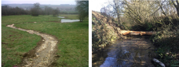
In Year 1 of the project, a tributary catchment (16.3km2) trial in Littlestock Brook was set up with key landowners and the Parish Council. Opportunity mapping, site walkovers and modelling are being used to plan and implement a suite of NFM/WFD measures such as creating temporary water retention ponds in field corners, constructing bunds and scrapes to store more floodwater on grassland areas, installing woody material in-channel to create leaky dams, and land management changes including planting woodland in flood source areas and along flood pathways.
A project officer employed by the Evenlode Catchment Partnership in 2017 will work with partners to implement NFM and WFD opportunities across the 180km2 Upper Evenlode catchment. A key objective is to ensure full integration with Thames Water’s phosphate reduction project and Natural England’s Catchment Sensitive Farming initiative if opportunity mapping directs the project to work in the same tributaries of the Evenlode.
The results from this first NFM trial in the Thames Basin will contribute to the call nationally for evidence on the effectiveness of natural measures for flood risk in lowland catchments. Through an academic partnership a river level and turbidity monitoring network has been installed in Littlestock Brook. The plan is to engage the community to actively support this monitoring network. A key objective of this project is to determine whether multiple small-scale NFM interventions in these catchments can provide a material benefit to flood frequency and extent.
For these natural solutions to be successful, it is crucial to empower the community in decision-making and for them to take ownership of the local solutions employed. Employing an NFM project officer to work with the Evenlode Catchment Partnership is fulfilling Defra's ambition to develop community driven, catchment-based solutions to environmental issues through the forum of catchment partnerships.
Monitoring surveys and results
Lessons learnt
Image gallery
|
Catchment and subcatchment
Site
Project background
Cost for project phases
Reasons for river restoration
Measures
MonitoringHydromorphological quality elements
Biological quality elements
Physico-chemical quality elements
Any other monitoring, e.g. social, economic
Monitoring documents
Additional documents and videos
Additional links and references
Supplementary InformationEdit Supplementary Information
| ||||||||||||||||||||||||||||||||||||||||||||||||||||||||||||||||||||||||||||||||||||||||||||||||||||||||||||||||||||||||||||||||||||||||||||||||||||||||||||||||||||||||||||||||||

