Case study:River Cole- Life Project: Difference between revisions
No edit summary |
No edit summary |
||
| (9 intermediate revisions by 2 users not shown) | |||
| Line 15: | Line 15: | ||
|Contact organisation=River Restoration Centre | |Contact organisation=River Restoration Centre | ||
|Contact organisation url=www.therrc.co.uk | |Contact organisation url=www.therrc.co.uk | ||
|Partner organisations=Environment Agency, National Trust, Countryside Commission, Natural England, | |Partner organisations=European Commission (LIFE funding), River Restoration Project (now River Restoration Centre), Environment Agency, National Trust, Countryside Commission, English Nature (now Natural England), | ||
|Name of parent multi-site project=Case_study:River restoration: Benefits for integrated catchment management | |||
|Multi-site=No | |Multi-site=No | ||
|Project picture=Dsc00908.jpg | |Project picture=Dsc00908.jpg | ||
| Line 130: | Line 131: | ||
|Project completed=1996/12/31 | |Project completed=1996/12/31 | ||
|Total1 cost=450 | |Total1 cost=450 | ||
|Funding sources=EU LIFE Programme, Environment Agency, National Trust, Countryside Commission, English Nature, | |||
|Wrk and supervision cost=200 | |Wrk and supervision cost=200 | ||
}} | }} | ||
| Line 138: | Line 140: | ||
}} | }} | ||
{{Measures | {{Measures | ||
|Bank and bed modifications measure=Planting, Depth | |Bank and bed modifications measure=Planting, Depth variation, | ||
|Floodplain / River corridor=Floodplain spillways, | |Floodplain / River corridor=Floodplain spillways, | ||
|Planform / Channel pattern= | |Planform / Channel pattern=Creation of secondary channel, Adding sinuosity, Creation of backwater, | ||
|Other technical measure=Livestock access, New crossings | |Other technical measure=Livestock access, New crossings | ||
}} | }} | ||
| Line 152: | Line 154: | ||
|Control site used=No | |Control site used=No | ||
|Result=Improvement | |Result=Improvement | ||
}} | |||
{{Hydromorphological quality element table row | |||
|Element=Width & depth variation | |||
|Monitored before=No | |||
|Monitored after=Yes | |||
|Qualitative monitoring=Yes | |||
|Quantitative monitoring=No | |||
|Control site used=No | |||
|Result=Improvement | |||
}} | |||
{{Hydromorphological quality element table row | |||
|Element=Flow velocities | |||
|Monitored before=No | |||
|Monitored after=Yes | |||
|Qualitative monitoring=Yes | |||
|Quantitative monitoring=No | |||
|Control site used=No | |||
}} | }} | ||
{{End_table}} | {{End_table}} | ||
Latest revision as of 13:05, 5 November 2018
Project overview
| Status | Complete |
|---|---|
| Project web site | |
| Themes | Flood risk management, Habitat and biodiversity, Hydromorphology, Monitoring, Social benefits |
| Country | England |
| Main contact forename | Martin |
| Main contact surname | Janes |
| Main contact user ID | User:UlrikaRRC |
| Contact organisation | River Restoration Centre |
| Contact organisation web site | http://www.therrc.co.uk |
| Partner organisations | European Commission (LIFE funding), River Restoration Project (now River Restoration Centre), Environment Agency, National Trust, Countryside Commission, English Nature (now Natural England) |
| Parent multi-site project |
Case_study:River restoration: Benefits for integrated catchment management |
| This is a parent project encompassing the following projects |
No |
Project summary
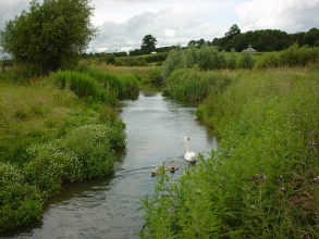
The River Cole at Coleshill is a tributary of the Thames and flows through National Trust owned farmland, North East of Swindon on the Oxfordshire and Wiltshire border.
Background: The river has a long history of modifications and already the Domesday Book of 1086 has a record of a mill in Coleshill. On the earliest map from the area, dated 1666, the river appears to have been straightened for milling. The section downstream of the mill has more recently been enlarged to safeguard agricultural production from flooding. Until the late 1700s, the mill was fed by a small artificial channel carrying water from the Cole, but by 1818 the mill leat had been largely extended to take the entire flow of the Cole, and most of the old river course filled in. This type of historical management is typical of many other rural rivers in the United Kingdom.
Restoration: The River Cole was included in a joint initiative between England and Denmark to demonstrate best practice in urban and rural river rehabilitation and encourage river restoration in Europe. The wider aim was to promote further river restoration and demonstrate how river restoration could provide multiple benefits such as enhancement in wildlife, landscape, recreation, water quality, fisheries, amenities and other local interests.
The restoration of the River Cole was initiated in July 1995. The site consists of a 2.5 km long reach divided into two parts, upstream and downstream of the mill. Upstream of the mill the river was restored to its original course (retaining a small flow in the mill leat) to join the old surviving mill by-pass channel. This new smaller channel encourages beneficial flood storage on the fields and allows fish to pass the mill weir. Downstream the river was reduced in size and remeandered across the old course to a more natural profile, retaining existing mature riverside trees. The restoration of bed level, water level and flood regime was achieved by cutting the new meandering river at a much higher level, similar to that prior to the last major deepening scheme of the 1970s.
Monitoring surveys and results
Pre-monitoring:
Ecology
• Macrophytes - number of species found per 500 meter channel length. • Macro-invertebrates - species richness and abundance, and as an indicator for water quality/organic pollution (BMWP). • Fish - biomass, density and species richness. • Birds - the assemblage of breeding birds and abundance
Hydromorphology
• Geomorphology - channel cross sections and physical habitat mapping. • The water quality - suspended sediment concentration, nitrogen and phosphorus. • Modeling flood frequency.
Post- monitoring:
Repetition of pre-monitoring was carried out 1 and 2 years after restoration, as well as a public perception survey. Due to its importance as a demonstration project, further monitoring been carried out by Master and PhD students.
Expectations and results:
It was expected that the new meandering channel would provide better habitat opportunities for aquatic species and the hydromorphology and flood frequency in the floodplain would improve because of the more natural channel dimension.
Ecology
Plant species richness increased immediately after restoration. Marginal emergent plant species richness increased significantly, but submerged aquatic plants showed a less immediate effect. The new upstream channel was quickly recolonized by macro-invertebrates. The downstream reach did not change significantly, but some more niche specific taxa were found 12 years after implementation. Two new species were found in the restored Cole, one stonefly (Leuctra geniculata) and a caddis fly (Athripsodes albifrons) Fish biomass and density returned to pre-restoration levels, and species richness remained unchanged. However, long-term surveys have shown an overall decline in fish density at both restored and control sites, indicating impact from an external factor. The number of breeding wetland species did not increase in the first year. The abundance of Yellow Wagtails (Motacilla flava) increased significantly. Casual inspection suggests little change after two years.
Hydromorphology
The river length was increased by 30%. The cross-sectional area was considerably smaller and less deep. The number of natural in-channel features, such as pools and riffles, increased after restoration. In the downstream section maturing trees also provide woody debris, creating habitats and flow diversity. The restoration measures recreated a more natural flooding regime.
Social
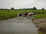
Public perception was measured via a questionnaire and 53% of the respondents in Coleshill mostly approved with the measures while 17% strongly approved. The long-term monitoring showed that only about half of the local residents strongly (25%) or mostly (31%) approved to the river restoration project. The restoration measures showed overall positive results for the ecological status. The downstream channel benefited greatly from the restoration measures, but the new upstream course was not fenced off from cattle and has therefore little riparian vegetation. However, due to lack of initial engagement, some local residents were unhappy with the project.
Lessons learnt
• Engaging the local community is critical
• In these early days of river restoration the project showed what could be expected from a restoration project and how it develops (might be different from anticipated) – this needs to be built into decision making process
• It is important to do a formal long-term management plan, and have a cooperating (and stable) land owner
• The project showed a whole suite of demonstration techniques (included in the Manual of River Restoration Techniques http://www.therrc.co.uk/rrc_manual.php)
• The project clearly showed the complexity of a linear system (compared with pond), and that it's difficult to distinguish success between different components
• The project gave a big boost to river restoration in the UK and showed that it is possible to do “large scale” (for that time) projects
Image gallery
|
Catchment and subcatchmentSelect a catchment/subcatchment
Catchment
Subcatchment
Site
Project background
Cost for project phases
Reasons for river restoration
Measures
MonitoringHydromorphological quality elements
Biological quality elements
Physico-chemical quality elements
Any other monitoring, e.g. social, economic
Monitoring documents
Additional documents and videos
Additional links and references
Supplementary InformationEdit Supplementary Information
| ||||||||||||||||||||||||||||||||||||||||||||||||||||||||||||||||||||||||||||||||||||||||||||||||||||||||||||||||||||||||||||||||||||||||||||||||||||||||||||||||||||||||||||||||||||||||||||||||||||||||||||||||||||||||||||||||||||||||||||


