Case study:Long Preston Deeps Flood Plain Project: Difference between revisions
No edit summary |
No edit summary |
||
| (10 intermediate revisions by 4 users not shown) | |||
| Line 1: | Line 1: | ||
{{Case study status | {{Case study status | ||
|Approval status= | |Approval status=Approved | ||
}} | }} | ||
{{Location | {{Location | ||
|Location=54. | |Location=54.04369217140143, -2.290778160095215 | ||
}} | }} | ||
{{Project overview | {{Project overview | ||
| Line 13: | Line 13: | ||
|Main contact surname=Whalley | |Main contact surname=Whalley | ||
|Main contact id=Awhalley | |Main contact id=Awhalley | ||
|Contact organisation=Environment Agency | |Contact organisation=Environment Agency | ||
|Contact organisation url=www.gov.uk/government/organisations/environment-agency | |Contact organisation url=www.gov.uk/government/organisations/environment-agency | ||
|Partner organisations=Long Preston Wet Grassland Project Group | |Partner organisations=Long Preston Wet Grassland Project Group, Natural England, RSPB, Yorkshire Millennium Trust, Ribble Rivers Trust, | ||
|Multi-site=No | |Multi-site=No | ||
|Project picture=LPDfloodplain.jpg | |Project picture=LPDfloodplain.jpg | ||
| Line 27: | Line 27: | ||
voluntary Environmental Stewardship Agreement using evidence based management | voluntary Environmental Stewardship Agreement using evidence based management | ||
plans. | plans. | ||
Partnership: Since 2004 over 10 organisations (Public/Private and Charitable)came together to develop a vision for the river and flood plain. Between 2005 and 2013 the implemented works | Partnership: Since 2004 over 10 organisations (Public/Private and Charitable)came together to develop a vision for the river and flood plain. Between 2005 and 2013 the partnership implemented works; achieving a sustainable current and future environmental and | ||
social resource. | social resource. | ||
| Line 92: | Line 92: | ||
- Those affected by the project need to trust those carrying out the project. They will still be farming the land in 20 years or fishing the banks. Trust is incredibly important. Local | - Those affected by the project need to trust those carrying out the project. They will still be farming the land in 20 years or fishing the banks. Trust is incredibly important. Local | ||
people should be utilised on the steering group and through the delivery of the project. | people should be utilised on the steering group and through the delivery of the project. | ||
Doing too much too quickly: | Doing too much too quickly: | ||
| Line 131: | Line 130: | ||
|Subcatchment=RIBBLE | |Subcatchment=RIBBLE | ||
}} | }} | ||
{{Site}} | {{Site | ||
|WFD water body code=GB531207112400 | |||
|WFD water body name=RIBBLE | |||
|Heavily modified water body=No | |||
|Protected species present=No | |||
|Invasive species present=No | |||
}} | |||
{{Project background | {{Project background | ||
|Reach length directly affected=7000 | |Reach length directly affected=7000 | ||
| Line 141: | Line 146: | ||
|Stakeholder engagement Lead organisation=Long Preston Wet Grassland Project Group | |Stakeholder engagement Lead organisation=Long Preston Wet Grassland Project Group | ||
}} | }} | ||
{{Motivations}} | {{Motivations | ||
{{Measures}} | |Specific mitigation=Land drainage, | ||
|Hydromorphological quality elements=Channel pattern/planform, | |||
}} | |||
{{Measures | |||
|Bank and bed modifications measure=Realignment of flood banks, | |||
|Floodplain / River corridor=River naturalisation, Scrapes, Reconnecting palaeo riverine features, Floodplain reconnection, | |||
}} | |||
{{Hydromorphological quality elements header}} | {{Hydromorphological quality elements header}} | ||
{{End table}} | {{End table}} | ||
Latest revision as of 15:23, 6 June 2017
Project overview
| Status | In progress |
|---|---|
| Project web site | http://www.longprestonwetgrasslandproject.co.uk/ |
| Themes | Environmental flows and water resources, Fisheries, Flood risk management, Habitat and biodiversity, Hydromorphology, Land use management - agriculture, Social benefits, Water quality |
| Country | England |
| Main contact forename | Alison |
| Main contact surname | Whalley |
| Main contact user ID | User:Awhalley |
| Contact organisation | Environment Agency |
| Contact organisation web site | http://www.gov.uk/government/organisations/environment-agency |
| Partner organisations | Long Preston Wet Grassland Project Group, Natural England, RSPB, Yorkshire Millennium Trust, Ribble Rivers Trust |
| Parent multi-site project | |
| This is a parent project encompassing the following projects |
No |
Project summary
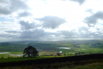
The flood plain project is a combined flood plain and river restoration project.
Main drivers for the project: UK: Site Special Scientific Interest remedies, UK Biodiversity Action Plan Targets, UK Climate Change adaptation, UK: Water Quality targets EU: Water Framework Directive.
Main Outcomes:
Key Outcome 1: Long Preston Wet Grassland: Project achieved 97% of 765 hectares of floodplain into voluntary Environmental Stewardship Agreement using evidence based management plans. Partnership: Since 2004 over 10 organisations (Public/Private and Charitable)came together to develop a vision for the river and flood plain. Between 2005 and 2013 the partnership implemented works; achieving a sustainable current and future environmental and social resource.
Baseline: In 2004 The flood plain baseline indicated by Site of Special Scientific Interest monitoring indicated that the site had high potential to support wading and over wintering birds but condition assessments indicated degraded habitat.
Result: Ongoing monitoring indicated site is now nationally important for several species of breeding wading bird of conservation concern; at least 60 pairs breed there. More than 2500 individual overwintering waders and wildfowl have been counted in recent winters. 97% of 765 hectares of floodplain is now in some form of voluntary Environmental Stewardship Agreement. SSSI condition statement has highlighted site is now recovering.
Key Outcome 2: Long Preston Deeps River Restoration: Between 2009 and 2013 the partnership produced a strategic river restoration plan for 7km and implemented over 3.5 km of naturalisation and restoration with riverine floodplain improvements of >15 hectares.
The river naturalisation was designed and carried out to enable minimal future human intervention. Complementary strategic management projects including River Ribble Invasive Species Project were developed and implemented alongside.
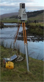
Monitoring: Wide range of monitoring techniques from standard SSSI conditions assessment, fish surveys, University of Salford hydrological monitoring, RSPB bird surveys, kite photography surveys, Archaeology watching briefs. University of Salford monitoring results demonstrate naturalisation techniques have been successful in reducing erosion and stabilising in channel morphology. Fish and Bird surveys indicate desirable species are increasing in number. Visitor number increasing utilising promotional materials e.g. website, local businesses, interpretation boards and organised events. Site used nationally as a case-study of WFD action implementation and river restoration conference sharing.
How was all of this achieved?: Strong partnership, Variety of communication strategies, Excellent consultation, ambitious multi objective vision, utilisation of voluntary government supported eco and farming sensitive sustainable management, showcasing success, detailed monitoring, community events and resources, dedicated long standing project officer, naturalisation to enable minimal future river intervention, complementary projects, recording, sharing and learning from lessons learnt, planning for the future, expanding partnership to incorporate new objectives and funding sources.
Monitoring surveys and results
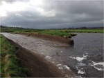
Monitoring of the site has revealed changes to the in-channel morphology following
several geomorphologically effective floods, recording sediment shoaling, riffle
development and an overall slowing of erosion of the bed and banks. Reconnected palaeo
features have been rejuvenated; reducing overall erosive forces in the previously confined
main channel. Improved floodplain connectivity and increased floodplain area have led to
more frequent inundation and the deposition of significant quantities of overbank fines. Wetter habitats are also developing across the floodplain.
Lessons learnt
Communication:
- Consultation and communication of the vision and the business plan is
key to success.
- Groups of individuals representing a stakeholder interest do not response to
communication events equally. The communication style must be chosen to reflect
differing responses to change and different personalities types
- Professional communications teams should be used to establish methods.
- Use experts within the project team for example an agricultural expert to work with the farming community to assess pros and cons of project for the land owners;
- Detailed records of events and outcomes of consultations should be kept and widely
shared.
- More than one consultation event should be held and tailored to the required outcome.
The event should specify what it is not consulting on as well as what it is.
Techniques used: - There may be the need to revisit if monitoring results indicate methods have not been successful in delivering specified outcomes. Partners have a duty of care to landowners and riparian rights owners to ensure that if a risk based approach has been used and accepted, future tweaking may be required to achieve the desired outcome.
Localism and Trust: - Those affected by the project need to trust those carrying out the project. They will still be farming the land in 20 years or fishing the banks. Trust is incredibly important. Local people should be utilised on the steering group and through the delivery of the project.
Doing too much too quickly: - Delivering too much too quickly could cause problems for benefits realisation and local trust in the project. River restoration is mostly constrained to seasonal work in channel and on the flood embankments due to ecology, social and working conditions. Establish working window and ensure if work cannot comfortably be completed before the window ends; complete it next year or when funding is available.
Changing opportunities: - Constantly review opportunities of outcomes and funding options. New schemes, political agendas and ways of working rapidly change. Funding may not be available for some opportunities but working with a wide range of partners enables shared use of skills and resources.
Image gallery
|
Catchment and subcatchmentSelect a catchment/subcatchment
Catchment
Subcatchment
Other case studies in this subcatchment: Diffusing the Issue in rural Ribble, Ribble Life Together
Site
Project background
Cost for project phases
Reasons for river restoration
Measures
MonitoringHydromorphological quality elements
Biological quality elements
Physico-chemical quality elements
Any other monitoring, e.g. social, economic
Monitoring documents
Additional documents and videos
Additional links and references
Supplementary InformationEdit Supplementary Information
| ||||||||||||||||||||||||||||||||||||||||||||||||||||||||||||||||||||||||||||||||||||||||||||||||||||||||||||||||||||||||||||||||||||||||||||||||||||||||||||||||||||||||||||||||||||||||||||||||||||||||


