Case study:Barnes Common: Difference between revisions
No edit summary |
No edit summary |
||
| (9 intermediate revisions by 4 users not shown) | |||
| Line 1: | Line 1: | ||
{{ | {{Case study status | ||
|Approval status= | |Approval status=Approved | ||
}} | }} | ||
{{Location | {{Location | ||
| Line 20: | Line 13: | ||
|Contact organisation=Friends of Barnes Common | |Contact organisation=Friends of Barnes Common | ||
|Contact organisation url=www.barnescommon.org.uk/ | |Contact organisation url=www.barnescommon.org.uk/ | ||
|Partner organisations=London Borough of Richmond | |Partner organisations=London Borough of Richmond upon Thames, | ||
|Multi-site=No | |Multi-site=No | ||
|Project summary=Friends of Barnes Common in partnership with LBRuT have created a new reedbed on the | |Project picture=SAM 0208.jpg | ||
|Project summary=Friends of Barnes Common in partnership with LBRuT have created a new reedbed on the Beverley Brook 400m2 (20 x20) adjoining to the Beverley Brook. Wider aim of the project is to link up the reed beds in Richmond Park and the Wetland Centre. Create a new habitat for Barnes Common. Structural tree line/invertebrate productivity for foraging bats, plus bat roost potential; backwater; scalloped bays for marginal plants. | |||
Best practice management plan for commuting, foraging and roosting bats; watervoles, fisheries benefits and flood defence benefits; improvement of bankside for marginal plants and/or fringing reeds, strengthening wild life corridor along brook for birds, water voles, grass snakes, bats etc; enhance bankside marginal vegetation and provide suitable habitat for birds, invertebrates, plus potential for dispersal for the BAP species from London wetland centre e.g. water vole, grass snake; readily accessible to the public; forage area for bats. | Best practice management plan for commuting, foraging and roosting bats; watervoles, fisheries benefits and flood defence benefits; improvement of bankside for marginal plants and/or fringing reeds, strengthening wild life corridor along brook for birds, water voles, grass snakes, bats etc; enhance bankside marginal vegetation and provide suitable habitat for birds, invertebrates, plus potential for dispersal for the BAP species from London wetland centre e.g. water vole, grass snake; readily accessible to the public; forage area for bats. | ||
|Lessons learn=London Borough of Richmond with Friends of Barnes Common has created a 400 sq m reed-bed with ditch links to Beverley Brook. More marginal plants will be added this Autumn with further fine tuning if needed. The construction work started in February 2010 and took two weeks. Planting commenced in April 2010 and has continued through to August 2010: the early reed and yellow flag planting has been very successful, and with these (sourced from the local Kew pond) came limited quantities of Sweet Galingale sedge, greater willowherb etc to which we have thus far added marsh marigold, meadowsweet, purple loosestrife, hemp agrimony and ragged robin. The plan has always been that this site should be 'reed-fen' which is flooded in winter and dries out but stays moist in summer - and it appears that we have broadly achieved this aim, with the site dry at times and ponding when there is heavy rainfall, which is helping to maintain the new plantings, but which would drain out if we opened the sluices: equally the brook depth in winter, with sluices open, should allow a period of consistent flooding for weed control and to allow a backwater haven. | |Lessons learn=London Borough of Richmond with Friends of Barnes Common has created a 400 sq m reed-bed with ditch links to Beverley Brook. More marginal plants will be added this Autumn with further fine tuning if needed. The construction work started in February 2010 and took two weeks. Planting commenced in April 2010 and has continued through to August 2010: the early reed and yellow flag planting has been very successful, and with these (sourced from the local Kew pond) came limited quantities of Sweet Galingale sedge, greater willowherb etc to which we have thus far added marsh marigold, meadowsweet, purple loosestrife, hemp agrimony and ragged robin. The plan has always been that this site should be 'reed-fen' which is flooded in winter and dries out but stays moist in summer - and it appears that we have broadly achieved this aim, with the site dry at times and ponding when there is heavy rainfall, which is helping to maintain the new plantings, but which would drain out if we opened the sluices: equally the brook depth in winter, with sluices open, should allow a period of consistent flooding for weed control and to allow a backwater haven. | ||
}} | |||
{{Image gallery}} | |||
{{Case study image | |||
|File name=P8180084.jpg | |||
}} | }} | ||
{{Image_gallery_end}} | {{Image_gallery_end}} | ||
{{Toggle_button}} | {{Toggle_button}} | ||
{{Toggle_content_start}} | {{Toggle_content_start}} | ||
{{ | {{Case study subcatchment | ||
|Subcatchment= | |Subcatchment=Beverley Brook (Motspur Park to Thames) and Pyl Brook at West Barnes | ||
}} | }} | ||
{{Site | {{Site | ||
|WFD water body code=GB106039022850 | |||
|WFD water body name=Beverley Brook (Motspur Park to Thames) and Pyl Brook at West Barnes | |||
|Heavily modified water body=No | |||
|Protected species present=No | |||
|WFD water body code= | |Invasive species present=No | ||
|WFD water body name= | |||
|Heavily modified water body= | |||
|Protected species present= | |||
|Invasive species present= | |||
}} | }} | ||
{{ | {{Project background | ||
|Reach length directly affected= | |Reach length directly affected=20 m | ||
|Works started=2010/02/01 | |||
|Works completed=2010/03/31 | |||
|Total cost category=10 - 50 k€ | |||
| | |||
|Works completed= | |||
|Total cost category= | |||
}} | }} | ||
{{Motivations | {{Motivations | ||
Latest revision as of 15:16, 6 June 2017
Project overview
| Status | Complete |
|---|---|
| Project web site | |
| Themes | Flood risk management, Habitat and biodiversity, Social benefits |
| Country | England |
| Main contact forename | Mike |
| Main contact surname | Hildesley |
| Main contact user ID | |
| Contact organisation | Friends of Barnes Common |
| Contact organisation web site | http://www.barnescommon.org.uk/ |
| Partner organisations | London Borough of Richmond upon Thames |
| Parent multi-site project | |
| This is a parent project encompassing the following projects |
No |
Project summary
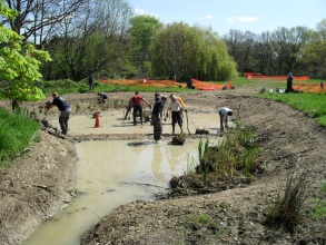
Friends of Barnes Common in partnership with LBRuT have created a new reedbed on the Beverley Brook 400m2 (20 x20) adjoining to the Beverley Brook. Wider aim of the project is to link up the reed beds in Richmond Park and the Wetland Centre. Create a new habitat for Barnes Common. Structural tree line/invertebrate productivity for foraging bats, plus bat roost potential; backwater; scalloped bays for marginal plants.
Best practice management plan for commuting, foraging and roosting bats; watervoles, fisheries benefits and flood defence benefits; improvement of bankside for marginal plants and/or fringing reeds, strengthening wild life corridor along brook for birds, water voles, grass snakes, bats etc; enhance bankside marginal vegetation and provide suitable habitat for birds, invertebrates, plus potential for dispersal for the BAP species from London wetland centre e.g. water vole, grass snake; readily accessible to the public; forage area for bats.
Monitoring surveys and results
Lessons learnt
London Borough of Richmond with Friends of Barnes Common has created a 400 sq m reed-bed with ditch links to Beverley Brook. More marginal plants will be added this Autumn with further fine tuning if needed. The construction work started in February 2010 and took two weeks. Planting commenced in April 2010 and has continued through to August 2010: the early reed and yellow flag planting has been very successful, and with these (sourced from the local Kew pond) came limited quantities of Sweet Galingale sedge, greater willowherb etc to which we have thus far added marsh marigold, meadowsweet, purple loosestrife, hemp agrimony and ragged robin. The plan has always been that this site should be 'reed-fen' which is flooded in winter and dries out but stays moist in summer - and it appears that we have broadly achieved this aim, with the site dry at times and ponding when there is heavy rainfall, which is helping to maintain the new plantings, but which would drain out if we opened the sluices: equally the brook depth in winter, with sluices open, should allow a period of consistent flooding for weed control and to allow a backwater haven.
Image gallery
|
Catchment and subcatchmentSelect a catchment/subcatchment
Catchment
Subcatchment
Other case studies in this subcatchment: Anton Crescent Wetlands Regeneration, Ashlone Wharf FCRM scheme, Barn Elms Sports Ground, Barn Elms Wetland Centre, South West London, Barnes Common improvements, Beverley Brook Flow control structures, Beverley Brook d/s of Rock’s Lane, Beverley Park, Cuddington Park, Horne Way Weir... further results
Site
Project background
Cost for project phases
Reasons for river restoration
Measures
MonitoringHydromorphological quality elements
Biological quality elements
Physico-chemical quality elements
Any other monitoring, e.g. social, economic
Monitoring documents
Additional documents and videos
Additional links and references
Supplementary InformationEdit Supplementary Information
| ||||||||||||||||||||||||||||||||||||||||||||||||||||||||||||||||||||||||||||||||||||||||||||||||||||||||||||||||||||||||||||||||||||||||||||||||||||||||||||||||||||||||||||||||||||||||||||||||||||||||


