Case study:Darley Abbey Fish Pass Project: Difference between revisions
Jump to navigation
Jump to search
No edit summary |
No edit summary |
||
| (24 intermediate revisions by 8 users not shown) | |||
| Line 1: | Line 1: | ||
{{Case study status | {{Case study status | ||
|Approval status= | |Approval status=Approved | ||
}} | |||
{{Location | |||
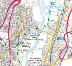
|Location=52.944086670427936, -1.4725112915039062 | |||
}} | }} | ||
{{Project overview | {{Project overview | ||
|Status= | |Status=Complete | ||
|Themes=Habitat and biodiversity | |Themes=Environmental flows and water resources, Fisheries, Habitat and biodiversity | ||
|Country=England | |Country=England | ||
|Main contact forename=Julie | |Main contact forename=Julie | ||
|Main contact surname=Wozniczka | |Main contact surname=Wozniczka | ||
| | |Contact organisation=Trent Rivers Trust | ||
|Partner organisations=Environment Agency, | |||
|Multi-site=No | |Multi-site=No | ||
|Project picture=Map with location.JPG | |||
|Project summary=The project aims to provide free upstream and downstream passage for all species of fish at Darley Abbey weir including eel. This will contribute significantly to the waterbody target of Achieving good ecological potential by 2027. | |||
Community involvement - Interpretation panel, launch event, heritage walks, archaeological assessment of medieval timbers excavated, community meetings re archaeology. | |||
}} | |||
{{Image gallery}} | |||
{{Case study image | |||
|File name=Map with location.JPG | |||
|Caption=Map with location | |||
}} | |||
{{Image gallery end}} | |||
{{Toggle button}} | |||
{{Toggle content start}} | |||
{{Case study subcatchment | |||
|Subcatchment=River Derwent from Bottle Brook to R Trent | |||
}} | |||
{{Site | |||
|Name=Darley Abbey | |||
|WFD water body code=GB104028053240 | |||
|WFD water body name=River Derwent from Bottle Brook to R Trent | |||
|Heavily modified water body=No | |||
|Site designation=International - World Heritage Site | |||
|Protected species present=No | |||
|Invasive species present=No | |||
}} | |||
{{Project background | |||
|Project started=2012/07/01 | |||
|Project completed=2015/03/01 | |||
|Total cost category=100 - 500 k€ | |||
|Total1 cost=450 | |||
|Funding sources=Defra Catchment Restoration Fund, | |||
}} | |||
{{Motivations | |||
|Specific mitigation=Barriers to fish migration | |||
|Hydromorphological quality elements=Continuity for organisms | |||
|Biological quality elements=Fish | |||
}} | |||
{{Measures | |||
|Planform / Channel pattern=Creation of fish passes, | |||
|Social measures=Interpretation boards, Heritage walks, Community consultation, Community Events, | |||
|Wider stakeholder / citizen engagement=Film made | |||
}} | }} | ||
{{Hydromorphological quality elements header}} | {{Hydromorphological quality elements header}} | ||
{{End table}} | {{End table}} | ||
| Line 26: | Line 65: | ||
{{End table}} | {{End table}} | ||
{{Monitoring documents}} | {{Monitoring documents}} | ||
{{Case study monitoring documents | |||
|Monitoring document=MID007 monitoring framework table.docx | |||
|Description=RRC Monitoring table - Darley | |||
}} | |||
{{Monitoring documents end}} | {{Monitoring documents end}} | ||
{{Additional Documents}} | {{Additional Documents}} | ||
{{Case study documents | |||
|File name=CRF018 Project Briefing Note - Darley.pdf | |||
|Description=CRF Briefing note - Darley | |||
}} | |||
{{Additional Documents end}} | {{Additional Documents end}} | ||
{{Additional links and references header}} | {{Additional links and references header}} | ||
{{Additional links and references footer}} | {{Additional links and references footer}} | ||
{{Supplementary Information}} | {{Supplementary Information}} | ||
{{Toggle content end}} | |||
Latest revision as of 08:36, 6 June 2017
Location: 52° 56' 38.71" N, 1° 28' 21.04" W
Left click to look around in the map, and use the wheel of your mouse to zoom in and out.
Project overview
| Status | Complete |
|---|---|
| Project web site | |
| Themes | Environmental flows and water resources, Fisheries, Habitat and biodiversity |
| Country | England |
| Main contact forename | Julie |
| Main contact surname | Wozniczka |
| Main contact user ID | |
| Contact organisation | Trent Rivers Trust |
| Contact organisation web site | |
| Partner organisations | Environment Agency |
| Parent multi-site project | |
| This is a parent project encompassing the following projects |
No |
Project summary
Edit project overview to modify the project summary.
The project aims to provide free upstream and downstream passage for all species of fish at Darley Abbey weir including eel. This will contribute significantly to the waterbody target of Achieving good ecological potential by 2027.
Community involvement - Interpretation panel, launch event, heritage walks, archaeological assessment of medieval timbers excavated, community meetings re archaeology.
Monitoring surveys and results
This case study hasn’t got any Monitoring survey and results, you can add some by editing the project overview.
Lessons learnt
This case study hasn’t got any lessons learnt, you can add some by editing the project overview.
Image gallery
|
Catchment and subcatchmentSelect a catchment/subcatchment
Catchment
Subcatchment
Other case studies in this subcatchment: Borrowash fish pass
Site
Project background
Cost for project phases
Reasons for river restoration
Measures
MonitoringHydromorphological quality elements
Biological quality elements
Physico-chemical quality elements
Any other monitoring, e.g. social, economic
Monitoring documents
Additional documents and videos
Additional links and references
Supplementary InformationEdit Supplementary Information
| ||||||||||||||||||||||||||||||||||||||||||||||||||||||||||||||||||||||||||||||||||||||||||||||||||||||||||||||||||||||||||||||||||||||||||||||||||||||||||||||||||||||||||||||||||||||||||||||||||||||||


