Case study:River Dearne at Mexborough: Difference between revisions
No edit summary |
No edit summary |
||
| (18 intermediate revisions by 4 users not shown) | |||
| Line 1: | Line 1: | ||
{{Case study status | {{Case study status | ||
|Approval status= | |Approval status=Approved | ||
}} | }} | ||
{{Location | {{Location | ||
| Line 6: | Line 6: | ||
}} | }} | ||
{{Project overview | {{Project overview | ||
|Status=Complete | |Status=Complete | ||
|Themes=Fisheries, Flood risk management, Habitat and biodiversity | |Themes=Fisheries, Flood risk management, Habitat and biodiversity | ||
| Line 15: | Line 14: | ||
|Contact organisation url=www.dcrt.org.uk/ | |Contact organisation url=www.dcrt.org.uk/ | ||
|Multi-site=No | |Multi-site=No | ||
|Project picture=RiverDearne Siteplan.jpg | |||
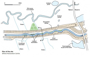
|Picture description=Site plan for the restored reach | |||
|Project summary=The lower River Dearne had suffered substantial changes to its natural gradient as a result of subsidence problems cause by deep mining operations. To alleviate this problem a new straight and over-wide river was created in the 1970s to ensure efficient evacuation of floodwaters. | |||
This resulted in physical uniformity of the channel, poor water quality and a lack of habitats for fish and other species. | |||
The restoration scheme drastically reduced the width of the channel (10m to 5.5m) by creating a sinuous course and low flow channel using large boulders to create berms. Flood capacity was maintained by ensuring the in-channel structures were kept to a low level and the berms were designed to be submerged during high flow events. The design included three small backwaters and scrapes and the low berms were created at a variety of levels to enable the establishment of a range of riparian communities and provide habitats for a range of species. | |||
Reduced maintenance (est. £2, 500-£3, 000 reduction in maintenance costs per year) | |||
}} | |||
{{Image gallery}} | |||
{{Case study image | |||
|File name=Dearne a.jpg | |||
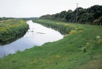
|Caption=Canalised reach before restoration works | |||
}} | |||
{{Case study image | |||
|File name=Dearne 3 6 3.jpg | |||
|Caption=Placement of limestone boulders and berm back-filling | |||
}} | |||
{{Case study image | |||
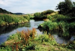
|File name=Dearne l.jpg | |||
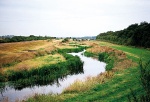
|Caption=New sinuous reed-fringed course following restoration | |||
}} | |||
{{Case study image | |||
|File name=Dearne f.jpg | |||
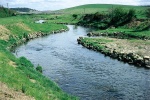
|Caption=Narrowed channel with increased velocities and riffles for fish spawning | |||
}} | |||
{{Case study image | |||
|File name=Dearne 3 6 5.jpg | |||
|Caption=Main channel and back water five years on, 2000 | |||
}} | |||
{{Case study image | |||
|File name=River Dearne Operational backwater channel.JPG | |||
|Caption=Main channel and operational backwater, 2012 | |||
}} | |||
{{Case study image | |||
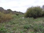
|File name=RiverDearne Silted.JPG | |||
|Caption=Silted backwater channel, 2012 | |||
}} | |||
{{Image gallery end}} | |||
{{Toggle button}} | |||
{{Toggle content start}} | |||
{{Case study subcatchment | |||
|Subcatchment=River Dearne Darfield STW to River Don | |||
}} | }} | ||
{{Site | {{Site | ||
|Name=River Dearne at Mexborough | |Name=River Dearne at Mexborough | ||
|WFD water body code=GB104027063173 | |WFD water body code=GB104027063173 | ||
|WFD water body name=River Dearne Darfield STW to River Don | |||
|Pre-project morphology=Straightened, Over-widened, Uniform | |Pre-project morphology=Straightened, Over-widened, Uniform | ||
|Reference morphology=Sinuous, narrower low flow channel | |Reference morphology=Sinuous, narrower low flow channel | ||
| Line 25: | Line 68: | ||
|Protected species present=No | |Protected species present=No | ||
|Invasive species present=No | |Invasive species present=No | ||
|Dominant substrate=Gravel, | |Dominant substrate=Gravel, | ||
|River corridor land use=Agriculture (arable), | |River corridor land use=Agriculture (arable), | ||
|Avrg bankfull channel width=5.5 | |||
}} | }} | ||
{{Project background | {{Project background | ||
| Line 33: | Line 77: | ||
|Project completed=1995/09/01 | |Project completed=1995/09/01 | ||
|Total cost category=10 - 50 k€ | |Total cost category=10 - 50 k€ | ||
|Total1 cost= | |Total1 cost=£43,000 | ||
}} | |||
{{Motivations | |||
|Hydromorphological quality elements=Channel pattern/planform, | |||
|Biological quality elements=Fish, | |||
}} | |||
{{Measures | |||
|Bank and bed modifications measure=Adding sinuosity, | |||
|Floodplain / River corridor=Creation of backwaters, | |||
|Planform / Channel pattern=Channel narrowing, Creation of backwater, | |||
|Management interventions=Reduced maintenance, | |||
}} | }} | ||
{{Hydromorphological quality elements header}} | {{Hydromorphological quality elements header}} | ||
{{End table}} | {{End table}} | ||
{{Biological quality elements header}} | {{Biological quality elements header}} | ||
{{Biological quality element table row | |||
|Element=Fish: Abundance | |||
|Monitored before=Yes | |||
|Monitored after=Yes | |||
|Qualitative monitoring=Yes | |||
|Quantitative monitoring=Yes | |||
|Control site used=No | |||
|Result=Improvement | |||
}} | |||
{{End table}} | {{End table}} | ||
{{Physico-chemical quality elements header}} | {{Physico-chemical quality elements header}} | ||
| Line 47: | Line 108: | ||
{{Monitoring documents}} | {{Monitoring documents}} | ||
{{Monitoring documents end}} | {{Monitoring documents end}} | ||
{{Additional Documents}} | {{Additional Documents}} | ||
{{Additional Documents end}} | {{Additional Documents end}} | ||
{{Additional links and references header}} | {{Additional links and references header}} | ||
{{Additional links and references | |||
|Link=www.therrc.co.uk/pdf/manual/MAN_3_6.pdf | |||
|Description=RRC Manual of River Restoration Techniques entry | |||
}} | |||
{{Additional links and references footer}} | {{Additional links and references footer}} | ||
{{Supplementary Information}} | {{Supplementary Information}} | ||
{{Toggle content end}} | |||
Latest revision as of 11:09, 5 June 2017
Project overview
| Status | Complete |
|---|---|
| Project web site | |
| Themes | Fisheries, Flood risk management, Habitat and biodiversity |
| Country | England |
| Main contact forename | Chris |
| Main contact surname | Firth |
| Main contact user ID | |
| Contact organisation | Don Catchment Rivers Trust |
| Contact organisation web site | http://www.dcrt.org.uk/ |
| Partner organisations | |
| Parent multi-site project | |
| This is a parent project encompassing the following projects |
No |
Project summary
The lower River Dearne had suffered substantial changes to its natural gradient as a result of subsidence problems cause by deep mining operations. To alleviate this problem a new straight and over-wide river was created in the 1970s to ensure efficient evacuation of floodwaters.
This resulted in physical uniformity of the channel, poor water quality and a lack of habitats for fish and other species.
The restoration scheme drastically reduced the width of the channel (10m to 5.5m) by creating a sinuous course and low flow channel using large boulders to create berms. Flood capacity was maintained by ensuring the in-channel structures were kept to a low level and the berms were designed to be submerged during high flow events. The design included three small backwaters and scrapes and the low berms were created at a variety of levels to enable the establishment of a range of riparian communities and provide habitats for a range of species.
Reduced maintenance (est. £2, 500-£3, 000 reduction in maintenance costs per year)
Monitoring surveys and results
Lessons learnt
Image gallery
|
Catchment and subcatchmentSelect a catchment/subcatchment
Catchment
Subcatchment
Site
Project background
Cost for project phases
Reasons for river restoration
Measures
MonitoringHydromorphological quality elements
Biological quality elements
Physico-chemical quality elements
Any other monitoring, e.g. social, economic
Monitoring documents
Additional documents and videos
Additional links and references
Supplementary InformationEdit Supplementary Information
| |||||||||||||||||||||||||||||||||||||||||||||||||||||||||||||||||||||||||||||||||||||||||||||||||||||||||||||||||||||||||||||||||||||||||||||||||||||||||||||||||||||||||||||||||||||||||||||||||||||||||||||||||

