Case study:Woughton on the Green bank stabilization: Difference between revisions
Robclapham (talk | contribs) No edit summary |
No edit summary |
||
| (4 intermediate revisions by 2 users not shown) | |||
| Line 1: | Line 1: | ||
{{Case study status | {{Case study status | ||
|Approval status= | |Approval status=Approved | ||
}} | }} | ||
{{Location | {{Location | ||
| Line 15: | Line 15: | ||
|Multi-site=No | |Multi-site=No | ||
|Project picture=IMG 4832.JPG | |Project picture=IMG 4832.JPG | ||
|Project summary=Dog bathing and signal crayfish activity had significantly weakened a 30-metre section of bank on the Ouzel in Milton Keynes. Significant amounts of bank material were collapsing in to the river, contributing to deterioration of river habitats. Furthermore, there was concern that a well used footpath, adjacent to this section, was at risk of failure in the future if nothing were done to stabilize the bank. | |||
Works were jointly undertaken by the Environment Agency, Park's Trust and Volunteers to improve public safety and to prevent further deterioration of habitats. | |||
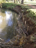
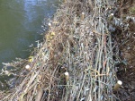
Willow logs and brash, were collected by the Park's Trust who were undertaking scheduled tree works in the area. These were secured in the channel using fence posts and steel fencing wire (see photos). | |||
|Lessons learn=While the project was successful at stabilizing the bank where it was most at risk (i.e. steep and close to public footpath), the bank poaching caused by dogs has just moved to another location. This should be considered in any similar project that seeks to restore bank that is deteriorating as a result of livestock or recreational activity. Consider where dogs or livestock will next enter the river, and consider whether the river at that point will be sensitive to the pressure. Are there any other unstable banks or important habitats such as spawning gravels that may be impacted? Consider whether fencing or formal drinking bathing points may be required. | |||
}} | }} | ||
{{Image gallery}} | {{Image gallery}} | ||
| Line 32: | Line 38: | ||
{{Toggle button}} | {{Toggle button}} | ||
{{Toggle content start}} | {{Toggle content start}} | ||
{{Case study subcatchment}} | {{Case study subcatchment | ||
|Subcatchment=Ouzel US Caldecote Mill | |||
}} | |||
{{Site | {{Site | ||
|Name=Woughton on the Green | |Name=Woughton on the Green | ||
| Line 71: | Line 79: | ||
|Other motivation=Prevent loss of adjacent footpath due to bank collapse | |Other motivation=Prevent loss of adjacent footpath due to bank collapse | ||
}} | }} | ||
{{Measures}} | {{Measures | ||
|Bank and bed modifications measure=Bank stabilisation, | |||
}} | |||
{{Hydromorphological quality elements header}} | {{Hydromorphological quality elements header}} | ||
{{End table}} | {{End table}} | ||
Latest revision as of 10:29, 6 January 2015
Project overview
| Status | Complete |
|---|---|
| Project web site | |
| Themes | Fisheries, Habitat and biodiversity |
| Country | England |
| Main contact forename | Rob |
| Main contact surname | Clapham |
| Main contact user ID | |
| Contact organisation | Environment Agency |
| Contact organisation web site | |
| Partner organisations | Milton Keynes Park's Trust |
| Parent multi-site project | |
| This is a parent project encompassing the following projects |
No |
Project summary
Dog bathing and signal crayfish activity had significantly weakened a 30-metre section of bank on the Ouzel in Milton Keynes. Significant amounts of bank material were collapsing in to the river, contributing to deterioration of river habitats. Furthermore, there was concern that a well used footpath, adjacent to this section, was at risk of failure in the future if nothing were done to stabilize the bank.
Works were jointly undertaken by the Environment Agency, Park's Trust and Volunteers to improve public safety and to prevent further deterioration of habitats.
Willow logs and brash, were collected by the Park's Trust who were undertaking scheduled tree works in the area. These were secured in the channel using fence posts and steel fencing wire (see photos).
Monitoring surveys and results
Lessons learnt
While the project was successful at stabilizing the bank where it was most at risk (i.e. steep and close to public footpath), the bank poaching caused by dogs has just moved to another location. This should be considered in any similar project that seeks to restore bank that is deteriorating as a result of livestock or recreational activity. Consider where dogs or livestock will next enter the river, and consider whether the river at that point will be sensitive to the pressure. Are there any other unstable banks or important habitats such as spawning gravels that may be impacted? Consider whether fencing or formal drinking bathing points may be required.
Image gallery
|
Catchment and subcatchmentSelect a catchment/subcatchment
Catchment
Subcatchment
Other case studies in this subcatchment: Ouzel habitat improvement
Site
Project background
Cost for project phases
Reasons for river restoration
Measures
MonitoringHydromorphological quality elements
Biological quality elements
Physico-chemical quality elements
Any other monitoring, e.g. social, economic
Monitoring documents
Additional documents and videos
Additional links and references
Supplementary InformationEdit Supplementary Information
| ||||||||||||||||||||||||||||||||||||||||||||||||||||||||||||||||||||||||||||||||||||||||||||||||||||||||||||||||||||||||||||||||||||||||||||||||||||||||||||||||||||||||||||||||||||||||||||||||||||||||


