Case study:River of Life: Difference between revisions
No edit summary |
No edit summary |
||
| Line 53: | Line 53: | ||
}} | }} | ||
{{Case study image | {{Case study image | ||
|File name= | |File name=Plan view map (Earth Trust).gif | ||
|Caption=River of Life plan view map (the Earth Trust) | |Caption=River of Life plan view map (the Earth Trust) | ||
}} | }} | ||
Revision as of 15:13, 11 February 2014
This case study is pending approval by a RiverWiki administrator.
Project overview
| Status | In progress |
|---|---|
| Project web site | http://www.earthtrust.org.uk/Our-work/waterandwetlands/RiverofLife.aspx |
| Themes | Fisheries, Habitat and biodiversity, Social benefits |
| Country | England |
| Main contact forename | Lizzie |
| Main contact surname | Rhymes |
| Main contact user ID | |
| Contact organisation | The Environment Agency |
| Contact organisation web site | http://http://www.environment-agency.gov.uk/news/151049.aspx |
| Partner organisations | The Earth Trust |
| Parent multi-site project | |
| This is a parent project encompassing the following projects |
No |
Project summary
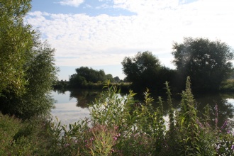
The Environment Agency and the Earth Trust are collaborating to restore wetland features and threatened wildlife habitats along two kilometers of the main River Thames in Oxfordshire.
The River of Life project will create a large area of biodiverse habitat, including backwaters and wetland scrapes, across approximately 50 hectares of Earth Trust land, with a vision to create a truly wild river reach.
Objectives
• To create a new landscape scale area of wetland habitats, including wet woodland, fen, reedbed, ponds and scrapes, backwaters and seasonally wet grassland and meadow.
• To address Water Framework Directive failure for fish along this section of the main Thames, by increasing the provision of backwater and sheltered habitat to act as spawning areas for fish and provide refuge areas at times of high flow.
• To engage people with habitats by providing access routes, opportunities for volunteering and learning. By providing boardwalks, viewing platforms and linking with the Thames footpath to encourage exploration and engagement with water.
• To enhance the value of ecosystems services, including the provision of: biodiverse habitat, fish refuge, recreation, flood alleviation, flow regulation, water and soil quality improvement and carbon sequestration.
Design and technique
Since works began in October 2013, seven new ponds, two reed beds and five new backwaters have been created at the site. To date over 15,000m3 of soil has been removed from the floodplain to land in the upper catchment also owned by the trust, helping to create additional flood storage. In total the finished scheme hopes to create c. 34,600 cubic meters of extra capacity within the one in five years flood zone. The project plans outline four main breaches. All backwaters will be linked to the main Thames, allowing fish to move in and out freely.
The project will take place in three phases; firstly the hard landscaping to excavate backwaters, scrapes and ponds, which is now complete. This phase was led by the Environment Agency. The second phase which will being in the spring of 2014 will encompass more detailed habitat creation, such as planting of willow, reedbed, wet woodland and grassland restoration. Finally the site will be made ready for general public access by installing information boards, creation of new footpaths linking to the Thames footpath and coordinating events and activities. The last two phases of the project will be led by the Earth Trust.
The new habitat area will link to Wittenham Wood SSSI (Site of Special Scientific Interest) and SAC (Special Conservation Area). Together, this area will now form a continuous expanse of 150ha of diverse wildlife habitat.
The site is in a Biodiversity Opportunity Area identified by Thames Valley Environmental Records Centre. It will benefit many BAP (Biodiversity Action Plan) priority species including; seven species of birds, seven species of invertebrate, four herptiles, as well as brown hare, otter, water vole, brown long-eared and soprano pipstrelle bat.
The River Restoration Centre would like to thank the Environment Agency and the Earth Trust for providing the information, pictures and plans for this case study.
Monitoring surveys and results
Electrofishing will be repeated post project to assess Water Framework Directive improvement for fish.
An ecosystems services assessment will be carried out post-project. This aims to assess if land productivity can be maintained, or even improved post project.
Water quality monitoring will be carried out to assess the effects of reedbeds and other measures.
There will be a range of opportunities for volunteering during phase two and three of the project, as well as part of the subsequent management of the site to undertake monitoring and maintenance, coordinated by the Earth Trust.
Lessons learnt
Image gallery
|
Catchment and subcatchmentSelect a catchment/subcatchment
Catchment
Subcatchment
Site
Project background
Cost for project phases
Supplementary funding informationThis project has been jointly funded and delivered by the Environment Agency and the Earth Trust.
Reasons for river restoration
Measures
MonitoringHydromorphological quality elements
Biological quality elements
Physico-chemical quality elements
Any other monitoring, e.g. social, economic
Monitoring documents
Additional documents and videos
Additional links and references
Supplementary InformationEdit Supplementary Information
| ||||||||||||||||||||||||||||||||||||||||||||||||||||||||||||||||||||||||||||||||||||||||||||||||||||||||||||||||||||||||||||||||||||||||||||||||||||||||||||||||||||||||||||||||||||||||||||||||||||||||||||||||||||||||||||||||


