Case study:Spring Meadow Meander Restoration: Difference between revisions
No edit summary |
No edit summary |
||
| Line 44: | Line 44: | ||
{{Case study image | {{Case study image | ||
|File name=2013-10-24 12.44.15.jpg | |File name=2013-10-24 12.44.15.jpg | ||
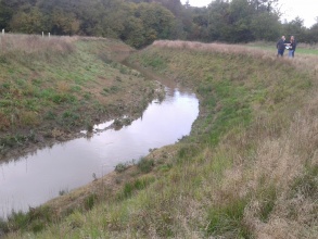
|Caption=Re-instated meander, looking | |Caption=Re-instated meander, looking downstream - © Nick Elbourne (RRC), October 2013 | ||
}} | }} | ||
{{Case study image | {{Case study image | ||
Revision as of 11:56, 11 December 2013
This case study is pending approval by a RiverWiki administrator.
Project overview
| Status | Complete |
|---|---|
| Project web site | http://www.oart.org.uk/projects/morph-sheffield-park.htm |
| Themes | Fisheries, Flood risk management, Habitat and biodiversity, Hydromorphology, Monitoring |
| Country | England |
| Main contact forename | Peter |
| Main contact surname | King |
| Main contact user ID | |
| Contact organisation | Ouse and Adur Rivers Trust |
| Contact organisation web site | http://www.oart.org.uk/ |
| Partner organisations | Environment Agency, Royal HaskoningDHV, C A Blackwell |
| Parent multi-site project | |
| This is a parent project encompassing the following projects |
No |
Project summary
The project is one of thirteen projects within the Middle Ouse Restoration of Physical Habitats (MORPH) project; led by the Environment Agency in partnership with the Ouse & Adur Rivers Trust (OART) & supported by Royal HaskoningDHV (design, engineering and environmental consultancy services) and C A Blackwell (contractor for the implementation works). Each of these project is being considered individually but also in terms of how they will work in conjunction with each other to improve the diversity of the river and reduce flood risk.
The Spring Meadow project had its own specific aims: - Reinstate the historic course of the river through the re-excavation of the visible meander; - Increase in channel habitat diversity for multiple fish species; - Increase floodplain functioning through new bank profiling; - Increase overall biodiversity to the area; - Restore existing wet meadow habitats.
Monitoring surveys and results
Working with University of Brighton, the project has set up a long term monitoring programme to look at and assess geomorphological changes, seed dispersal of Himalayan Balsam, and hay meadow restoration techniques.
Lessons learnt
The design of the new two-stage channel (incorporating a low flow channel) has increased water depth during low flows. In combination with a greater variety of channel widths and depths, this has increased habitat diversity which should benefit fish populations.
Within a year of the project works, native vegetation had begun to establish on the banks. This will provide shelter and feeding areas for fish during high flows and will increase habitat for invertebrate species such as dragonflies, beetles and fly species.
The newly created backwater will provide refuge for juveile fish, create warmer conditions and shallow refugia as nursey areas for young amphibians and invertebrates which live in still water. The introduction of woody material provides shelter during low flows and marginal shelves will become vegetated and provide areas for feeding and resting.
Out of channel habitat enhancement of floodplain woodland and additional lateral connectivity is expected to lead to improvements in the biodiversity value of the landscape (wet meadow habitats are nationally rare) & reduce flood risk downstream by increasing capacity for floodwaters.
The public have been consulted and kept informed of progress throughout the project, building local support for river restoration and its associated benefits.
Image gallery
|
Catchment and subcatchment
Site
Project background
Cost for project phases
Reasons for river restoration
Measures
MonitoringHydromorphological quality elements
Biological quality elements
Physico-chemical quality elements
Any other monitoring, e.g. social, economic
Monitoring documents
Additional documents and videos
Additional links and references
Supplementary InformationEdit Supplementary Information
| ||||||||||||||||||||||||||||||||||||||||||||||||||||||||||||||||||||||||||||||||||||||||||||||||||||||||||||||||||||||||||||||||||||||||||||||||||||||||||||||||||||||||||||||||||


