Case study:The Umbusi River
Project overview
| Status | Complete |
|---|---|
| Project web site | |
| Themes | Fisheries, Habitat and biodiversity, Water quality |
| Country | Estonia |
| Main contact forename | Kesler |
| Main contact surname | Martin |
| Main contact user ID | User:Kasvio |
| Contact organisation | |
| Contact organisation web site | |
| Partner organisations | |
| Parent multi-site project | |
| This is a parent project encompassing the following projects |
No |
Project summary
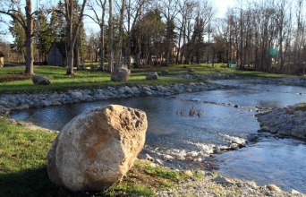
The Umbusi River is a tributary of the Pedja River in the lower course and it is located entirely in Jõgeva county. The length of the Umbusi River is 34 km and its catchment area is 159 km2. The upper course of the river is located on the plains of Central Estonia and the lower course is located in the Lake Võrtsjärve depression.
The Umbusi Rivers water was slightly alkaline in the summers of 1988 (pH value was 7,8) and 1994 (pH value was 7,7). There is no data about the mineral content of the water. The total content of organic matter in the water varies from high to low, depending on the location.
Various reports suggest that the Umbusi River is a habitat for roach, ide, perch and brown trout, minnow, pike. The Umbusi River’s middle and upper course areas with their cold water are known as highly valued places for trout fishing.
Recent work that has been done on the river: streambed redevelopment, renewal and construction of culverts, rocks, rapids in the streambed, sedimentation tank in the Kablaküla main ditch, the clearing of Lustivere barrage lake from sediments, the construction of 3 fish passes and 11 spawning beds.
The construction on those began in July 2010 and ended in November 2010. The total cost of it was 274 000 euros.
The construction on the spawning beds took place in the summer of 2013 and the total cost was 48 000 euros.
Monitoring surveys and results
Lessons learnt
Image gallery
|
Catchment and subcatchment
Site
Project background
Cost for project phases
Reasons for river restoration
Measures
MonitoringHydromorphological quality elements
Biological quality elements
Physico-chemical quality elements
Any other monitoring, e.g. social, economic
Monitoring documents
Additional documents and videos
Additional links and references
Supplementary InformationEdit Supplementary Information
| ||||||||||||||||||||||||||||||||||||||||||||||||||||||||||||||||||||||||||||||||||||||||||||||||||||||||||||||||||||||||||||||||||||||||||||||||||||||||||||||||||||||||||||||||||


