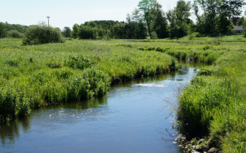
Case study:River Gelsa at Bevtoft
Project overview
| Status | Complete |
|---|---|
| Project web site | |
| Themes | Fisheries, Habitat and biodiversity |
| Country | Denmark |
| Main contact forename | Nick |
| Main contact surname | Elbourne |
| Main contact user ID | |
| Contact organisation | River Restoration Centre |
| Contact organisation web site | |
| Partner organisations | |
| Parent multi-site project | |
| This is a parent project encompassing the following projects |
No |
Project summary
From July to September 1989 a 1.3 km reach of the river which had historically been straightened and channelised, was restored to a 1.9 km meandering course.
Rip-rap structures were created in the new meanders using 1000 m3 of stone. 740m3 of gravels were used to create new spawning grounds.
In total sixteen new meanders were created, transforming the in stream morphology, decreasing channel width by 3-4m and reducing discharge capacity by around 50%. Sinuosity also increased from 1.15 and 1.60. A weir structure was also demolished just upstream of the project area as part of the restoration design.
A similar upstream reach was left in the original channelised state to act as a benchmark against which improvements in the restored channel could be measured. An extensive maintenance regime of dredging and mechanical weed clearance was altered to weed clearance by scythe, and later to no human intervention. This reach represents an alternative option for restoration, which relies on natural processes to take over without human intervention.
Post project monitoring was carried out in May in 1990, 1991, 1993 and 1995, as well as pre project monitoring. Results of monitoring showed nearly three times the macroinvertebrate population present post restoration. Numbers in the upstream reach which was left unaltered also increased between 1990 and 1995. Brown trout recovered to pre-restoration levels but not beyond.
The results also showed that the River Gelsa had stabilised by 1993, with changes in substrate and macroinvertebrate composition mainly taking place between 1993 and 1995. The unaltered reach also showed impressive natural recovery, indicating that the termination of maintenance practices can have a substantial effect on the stream environment. Additional of gravels would further improve the channel and could provide a very cost effective restoration strategy.
Nineteen years after restoration works were completed, hydromorphological conditions in the restored channel have developed in a very similar way to the unaltered channel. This supports the view that natural recovery without human intervention can be as effective as planned restoration.
Monitoring surveys and results
Lessons learnt
Image gallery
|
Catchment and subcatchmentSelect a catchment/subcatchment
Catchment
Subcatchment
Site
Project background
Cost for project phases
Reasons for river restoration
Measures
MonitoringHydromorphological quality elements
Biological quality elements
Physico-chemical quality elements
Any other monitoring, e.g. social, economic
Monitoring documents
Additional documents and videos
Additional links and references
Supplementary InformationEdit Supplementary Information Friberg, N., Kronvang, B., Svendsen, L.M., Hanse, H.O., Nielsen, N.B. (1994). Restoration of a channelized reach of the River Gelså, Denmark: Effects on the macroinvertebrate community. Aquatic Conservation: Marine and Freshwater Ecosystems, 4 (4), 289-296.
| ||||||||||||||||||||||||||||||||||||||||||||||||||||||||||||||||||||||||||||||||||||||||||||||||||||||||||||||||||||||||||||||||||||||||||||||||||||||||||||||||||||||||||||||||||||||||||||||||||||||||||||||

