Case study:River Avon Our Water Environment

From RESTORE
Jump to navigation Jump to search
0.00
(0 votes)


To discuss or comment on this case study, please use the discussion page.


Location: 57° 15' 6.32" N, 3° 23' 33.79" W
Loading map...
Left click to look around in the map, and use the wheel of your mouse to zoom in and out.


Project overview

Edit project overview
Status Complete
Project web site
Themes Flood risk management, Habitat and biodiversity, Social benefits, Water quality
Country Scotland
Main contact forename Jos
Main contact surname Milner
Main contact user ID
Contact organisation Tomintoul & Glenlivet Landscape Partnership
Contact organisation web site http://www.tomintoulandglenlivet.com/our-water-environment/
Partner organisations Spey Fishery Board, Cairngorms National Park Authority, Crown Estate Scotland, Delnabo Estate, Fordmouth Farm
Parent multi-site project
This is a parent project
encompassing the following
projects
No
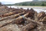
Engineered woody structure along river bank at Fordmouth Farm - soil scrapped back & 8m long tree trunks, with intact root plates towards river, located along bank prior to burying

Project summary

Edit project overview to modify the project summary.


River restoration works have been carried out along a high-energy reach of the River Avon within the River Spey Special Area of Conservation (SAC) in Cairngorms National Park. The project encompasses green engineering woody structures and sediment management, as well as water margin management and riparian planting. The aim is to improve the capability of the watercourse to cope with high flow events, reduce excessive erosion and to protect in-channel and riparian habitats, as well as farm livelihoods and infrastructure. The works were carried out as a Scottish Rural Development Programme (SRDP) Agri-Environment Climate Scheme (AECS), supported and managed by a National Lottery Heritage Funded partnership (Tomintoul & Glenlivet Landscape Partnership) as part of their wider ‘Our Water Environment’ project running across the Tomintoul and Glenlivet area.

Monitoring surveys and results

Edit project overview to modify the Monitoring survey and results.


Topographical survey, geomorphological assessment,fluvial audit carried out in 2018 (cbec); Hydromorphological survey in 2019 (EnviroCentre). Post-restoration monitoring surveys to be carried out in 2021 by Spey Fishery Board.

Lessons learnt

Edit project overview to modify the lessons learnt.


Cash flow was an issue as sizable sums required up front – project partner supported cash flow but the project could have been wider-reaching without this problem.

Significant up-front investment is required to carry out initial survey work required to be able to inform land owners / managers about risks involved and allow them to decide if this is something they can accommodate.

Lack of understanding about green engineering techniques means significant engagement is required early on to gain buy-in & permissions.

Scottish Rural Development Programme's Agri-Environment Climate Scheme (AECS) can be a good source of funding to deliver river restoration projects, but involves upfront payments which can subsequently be reclaimed.

Sourcing the tree trunks (250 in total) from a near-by plantation considerably reduced costs.


Image gallery


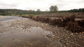
One of two areas of sediment to be removed to re-open a secondary channel (W.Boyd-Wallis-CNPA)
One of the log revetment sites before intervention showing bank erosion (note former fenceline between person & bankside trees). K.McDougall-EnviroCentre
Delivery of one load of tree trunks (250 trees used in total) K.McDougall-EnviroCentre
Tree trunks laid perpendicular to drainage ditch and main river channel
Installation of tree trunks with root plates aligned along bank toe line. Note excavated bank material piled to left & rocks being used to infill between logs). K.McDougall - EnviroCentre
Close-up of root balls which will form new bank
Fixings for log revetment (P.Lawson - Spey Catchment Initiative)
Tree trunks in 2 tiers seperated by logs at 90 degrees (K.McDougall - EnviroCentre)
River bank being reinstated by burying log revetment
Reinstated ground over log revetment (W.Boyd-Wallis-CNPA)
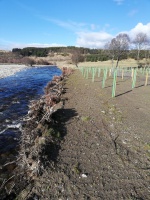
Riparian planting on reinstated ground above log revetment, showing root plates visible along river edge (J.Milner-TGLP)
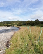
Riparian vegetation development one year after project completion. Note theroot plates of the log revetment just visible along the water edge (J.Milner-TGLP)
ShowHideAdditionalImage.png


Catchment and subcatchment

Catchment

River basin district Scotland RBD
River basin River Spey

Subcatchment

River name River Avon
Area category 100 - 1000 km²
Area (km2) 545545 km² <br />54,500 ha <br />
Maximum altitude category 500 - 1000 m
Maximum altitude (m) 700700 m <br />0.7 km <br />70,000 cm <br />
Dominant geology granite, sedimentary, metamorphosed sedimentary
Ecoregion Great Britain
Dominant land cover Moorland, agriculture, forestry
Waterbody ID 23084


Other case studies in this subcatchment: Allt Lorgy River Restoration


Site

Name Fordmouth Farm, Tomintoul
WFD water body codes
WFD (national) typology
WFD water body name River Avon
Pre-project morphology Wandering
Reference morphology
Desired post project morphology
Heavily modified water body No
National/international site designation EU - Special Area of Conservation
Local/regional site designations Cairngorms National Park
Protected species present Yes
Invasive species present No
Species of interest Atlantic salmon, European Otter, Sea lamprey, Freshwater pearl mussel (Margaritifera margaritifera)
Dominant hydrology
Dominant substrate Cobble
River corridor land use Improved/semi-improved grassland/pasture
Average bankfull channel width category
Average bankfull channel width (m)
Average bankfull channel depth category
Average bankfull channel depth (m)
Mean discharge category
Mean annual discharge (m3/s)
Average channel gradient category 0.001 - 0.01
Average channel gradient
Average unit stream power (W/m2) 198 198 W/m² <br />


Project background

Reach length directly affected (m) 180180 m <br />0.18 km <br />18,000 cm <br />
Project started 2015
Works started
Works completed
Project completed
Total cost category 50 - 100 k€
Total cost (k€)
Benefit to cost ratio
Funding sources Scottish Rural Development Programme, National Lottery Heritage Fund

Cost for project phases

Phase cost category cost exact (k€) Lead organisation Contact forename Contact surname
Investigation and design CBec Eco Engineering Hamish Moir
Stakeholder engagement and communication Tomintoul & Glenlivet Landscape Partnership
Works and works supervision EnviroCentre Kenneth MacDougall
Post-project management and maintenance Spey Fishery Board Duncan Ferguson
Monitoring Spey Fishery Board

Supplementary funding information

EnviroCentre undertook survey, design and construction support for the installation of green engineering features, based on options appraisal and initial design phase of work carried out by cbec. Contractor who carried out works: FM Land Ltd, Cromdale, Grantown-on-Spey


Reasons for river restoration

Mitigation of a pressure
Hydromorphology
Biology
Physico-chemical
Other reasons for the project Improve resilience to high flow events; reduce bank erosion & sedimentation; improve habitats


Measures

Structural measures
Bank/bed modifications Bank stabilisation using engineered wood structures; sediment management
Floodplain / River corridor
Planform / Channel pattern
Other Set-back fencing & riparian planting
Non-structural measures
Management interventions
Social measures (incl. engagement)
Other


Monitoring

Hydromorphological quality elements

Element When monitored Type of monitoring Control site used Result
Before measures After measures Qualitative Quantitative

Biological quality elements

Element When monitored Type of monitoring Control site used Result
Before measures After measures Qualitative Quantitative

Physico-chemical quality elements

Element When monitored Type of monitoring Control site used Result
Before measures After measures Qualitative Quantitative

Any other monitoring, e.g. social, economic

Element When monitored Type of monitoring Control site used Result
Before measures After measures Qualitative Quantitative


Monitoring documents


Additional documents and videos


Additional links and references

Link Description
http://www.therrc.co.uk/blog/our-water-environment-restoration-river-avon-catchment-cairngorms-national-park Guest blog - Our Water Environment green engineering projects

Supplementary Information

Edit Supplementary Information