Case study:Rio Mareta restoration at Stanghe (Sterzing-Vipiteno)

From RESTORE
Jump to navigation Jump to search
0.00
(0 votes)


To discuss or comment on this case study, please use the discussion page.


Location: 46° 53' 4.17" N, 11° 23' 2.02" E
Loading map...
Left click to look around in the map, and use the wheel of your mouse to zoom in and out.


Project overview

Edit project overview
Status In progress
Project web site
Themes Flood risk management, Habitat and biodiversity, Hydromorphology
Country Italy
Main contact forename Peter
Main contact surname Hecher
Main contact user ID
Contact organisation Provincia Autonoma di Bolzano
Contact organisation web site
Partner organisations
Parent multi-site project
This is a parent project
encompassing the following
projects
No
Project picture

Project summary

Edit project overview to modify the project summary.


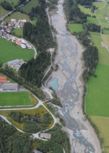
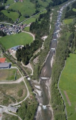
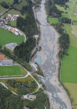
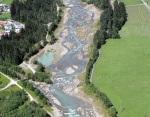
The Mareta River drains a catchement area of 212 Km and flows into the Isarco River, near Sterzing (Vipiteno). In the last 150 years, the river was object of various intervention; the two major consist of a flow regulation in 1876 and a large aggregates extraction, to provide material for the construction of the Brennero motorway, in the early 70’s. These activities caused a significant incision and narrowing of the riverbed (from the large original braided river bed – up to 300 m width – to a channel 30-40 m wide). The areas of natural retention, such as flood plains and riparian areas, have almost completely disappeared, making floods more intense in the Vipiteno basin. Using public lands has been possible to enlarge the riverbed up to twice the width set in the 70’s, along a stretch of 2 km, The material of the excavations has been deposited in the river bed, taking care to reproduce forms as natural as possible. To restore the longitudinal continuity, 16 dams has been demolished, with benefits to the ecosystem and fish populations for the morphological evolution of the stream itself, which is to be returned as a dynamic system . To ensure flood safety the new bed was consolidated by bank protections, covered with loose material and harmonized with the surrounding landscape.

Monitoring surveys and results

This case study hasn’t got any Monitoring survey and results, you can add some by editing the project overview.

Lessons learnt

This case study hasn’t got any lessons learnt, you can add some by editing the project overview.


Image gallery


Rio Mareta in 2005, before restoration works.
Rio Mareta in 2010, after restoration works.
Rio Mareta in 2012.
The rio Mareta restoration works: a dam removal (left) and riverdeb consolidation (right).
The Rio mareta new bed was consolidated by stones, covered with loose material.
ShowHideAdditionalImage.png


Catchment and subcatchment

Catchment

River basin district Alpi Orientali
River basin Adige

Subcatchment

River name rio Mareta
Area category
Area (km2) 212212 km² <br />21,200 ha <br />
Maximum altitude category
Maximum altitude (m)
Dominant geology
Ecoregion Alps
Dominant land cover
Waterbody ID


Site

Name Stanghe (Sterzing-Vipiteno)
WFD water body codes
WFD (national) typology
WFD water body name
Pre-project morphology
Reference morphology
Desired post project morphology
Heavily modified water body No
National/international site designation
Local/regional site designations
Protected species present No
Invasive species present No
Species of interest
Dominant hydrology
Dominant substrate
River corridor land use
Average bankfull channel width category
Average bankfull channel width (m)
Average bankfull channel depth category
Average bankfull channel depth (m)
Mean discharge category
Mean annual discharge (m3/s)
Average channel gradient category
Average channel gradient
Average unit stream power (W/m2)


Project background

Reach length directly affected (m)
Project started
Works started 2008/01/01
Works completed 2010/10/31
Project completed
Total cost category
Total cost (k€)
Benefit to cost ratio
Funding sources UE founds (FESR 2007-2013)

Cost for project phases

Phase cost category cost exact (k€) Lead organisation Contact forename Contact surname
Investigation and design
Stakeholder engagement and communication
Works and works supervision
Post-project management and maintenance
Monitoring


Reasons for river restoration

Mitigation of a pressure Flood risk management
Hydromorphology Continuity of sediment transport
Biology Fish
Physico-chemical
Other reasons for the project


Measures

Structural measures
Bank/bed modifications Dam removal
Floodplain / River corridor
Planform / Channel pattern Channel widening
Other
Non-structural measures
Management interventions
Social measures (incl. engagement)
Other


Monitoring

Hydromorphological quality elements

Element When monitored Type of monitoring Control site used Result
Before measures After measures Qualitative Quantitative
Width & depth variation No Yes No No No Improvement
Channel pattern/planform No Yes Yes Yes No Improvement
Continuity of sediment transport No Yes No Yes No Improvement

Biological quality elements

Element When monitored Type of monitoring Control site used Result
Before measures After measures Qualitative Quantitative
Fish No Yes No Yes No
Invertebrates No Yes No No No

Physico-chemical quality elements

Element When monitored Type of monitoring Control site used Result
Before measures After measures Qualitative Quantitative

Any other monitoring, e.g. social, economic

Element When monitored Type of monitoring Control site used Result
Before measures After measures Qualitative Quantitative
river bank vegetation No Yes No No No
Birds No Yes No No No
Amphibians No Yes No No No
dragonflies No Yes No No No


Monitoring documents


Additional documents and videos


Additional links and references

Link Description

Supplementary Information

Edit Supplementary Information