Case study:Rheinfelden bypass
Project overview
| Status | Complete |
|---|---|
| Project web site | |
| Themes | Economic aspects, Fisheries, Habitat and biodiversity, Hydropower, Hydromorphology |
| Country | Germany, Switzerland |
| Main contact forename | Walter |
| Main contact surname | Binder |
| Main contact user ID | User:Kasvio |
| Contact organisation | |
| Contact organisation web site | |
| Partner organisations | |
| Parent multi-site project | |
| This is a parent project encompassing the following projects |
No |
Project summary
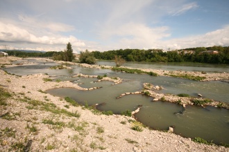
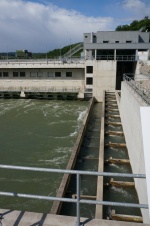
The bypassing water course at the hydropower plant Rheinfelden, on the High Rhine, is the largest fish pass facilitiy of this type in Central Europe. The old hydropower station was a diversion-channel type plant. The new station is a run-of-river power plant. Three fishways are installed, a vertical slot pass at the power house (left bank), the new bypassing river course installed in the old headrace channel(right bank) and a rock cascade pass which connect the tailwater of the weir with the river course.
The main intention of this new river course is to provide suitable habitat for rheophilic species, especially spawning grounds for gravel dependent fish species, for example barbel (Barbus barbus) and nase(Chondrostoma nasus).
With a width of 40-50 m, a mean gradient of 0.9 % and a discharge of up to 35 m³s-1 the bypass channel has the character of a mountain river. The mean discharge is 16 m3/s and the attraction flow is 15 m3/s.
The aim is to provide a high variety of bottom and flow structures induced by sequences of riffles, bars, pools and single gravel islands. The bed material consists of continuous gravel. In riffles and fast flowing reaches coarser material is provided. A deeper flow path ensures fish passage even at minor discharges. The river banks are characterized by bars, shallow regions, small bays, undercut banks and riparian vegetation. The bypass channel is connected to the weir impoundment with a gentle transition involving several braided channels. The intake structure itself is divided into two sections. One section will be controlled by two gates, the other will be unregulated. The unregulated section will guarantee a constant discharge of 10 m³s-1 in the bypass channel. Additional discharge up to 25 m³s-1 can be provided via the regulated gates in order to provide a dynamic flow regime.
The downstream entrance is designed as a rock ramp with a steeper gradient (3%), thus downstream water-level fluctuations are limited to this ramp; i.e. flow characteristics in potential spawning grounds in the bypass channel will not change. The cross-section at the mouth of the channel is narrowed to provide more efficient attraction flow into the tailrace.
The total cost of the project was 6 milj. € and the by-pass channel cost 4 milj. €. There is no constant monitoring yet, but they have calculated the amount of the fish in the by-pass channel to be 30 000. In the other fish way the number of fish was 3 000.
Monitoring surveys and results
Lessons learnt
Image gallery
|
Catchment and subcatchment
Site
Project background
Cost for project phases
Reasons for river restoration
Measures
MonitoringHydromorphological quality elements
Biological quality elements
Physico-chemical quality elements
Any other monitoring, e.g. social, economic
Monitoring documents
Additional documents and videos
Additional links and references
Supplementary InformationEdit Supplementary Information
| |||||||||||||||||||||||||||||||||||||||||||||||||||||||||||||||||||||||||||||||||||||||||||||||||||||||||||||||||||||||||||||||||||||||||||||||||||||||||||||||||||||||||||||||||||||||||


