Case study:Restoring the River Doquette to its original bed

From RESTORE
Jump to navigation Jump to search
0.00
(0 votes)


To discuss or comment on this case study, please use the discussion page.


Location: 48° 55' 23.07" N, 1° 14' 35.20" W
Loading map...
Left click to look around in the map, and use the wheel of your mouse to zoom in and out.


Project overview

Edit project overview
Status Complete
Project web site
Themes
Country France
Main contact forename Fabien
Main contact surname Goulmy
Main contact user ID
Contact organisation Fédération de la Manche pour la pêche et la protection du milieu aquatique
Contact organisation web site
Partner organisations
Parent multi-site project
This is a parent project
encompassing the following
projects
No
Doquette

Project summary

Edit project overview to modify the project summary.


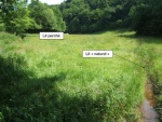
The Doquette is a small salmonid river, tributary of the River Sienne. The river is home to brown trout and bullhead; it is also likely to be colonised by Atlantic salmon. In the 1970s, a part of the Doquette was moved into a straight channel at the edge of a field. The original bed was retained and transformed into a drainage ditch. The river, now in a “raised” position, deteriorated. The flow patterns became uniform and the habitats of the low water channel became homogenised. Since being moved, the Doquette flowed over the bedrock and could dry out during the low-flow period. In application of the multi-annual restoration and maintenance programme for the catchment area of the River Sienne, there were plans to erect fencing along the raised river. The landowner, who had two channels on his plot, requested modifications in order to avoid the erection of fencing along both the raised river and the drained river. This double intervention would indeed have posed certain problems relating to the use of this land. The local institute in collaboration with the departmental fishing federation, thus proposed to restore the Doquette to its former bed, which would then be the only section to be fenced. The original river bed was wider (mean width of 4.5 metres). 136 tonnes of aggregates were brought in from a quarry and deposited in the river. 77 tonnes of stones and pebbles (from 0 to 250 mm), were used to form the armour layer, with the remaining 59 tonnes being used to reconstitute the alluvial mattress. A connection was made with the river, while the existing connection with the straightened bed was blocked. The old, spring-fed channel was not filled in. Both banks of the restored river were fenced and a ford crossing and drinking trough were installed.

Monitoring surveys and results

This case study hasn’t got any Monitoring survey and results, you can add some by editing the project overview.

Lessons learnt

This case study hasn’t got any lessons learnt, you can add some by editing the project overview.


Image gallery


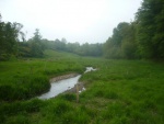
The Doquette in June 2008, prior to restoration with its raised bed (on the left) and its natural bed now used as a drainage ditch (on the right).
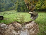
The works phase during the restoration of the Doquette in October 2008.
The works phase during the restoration of the Doquette in October 2008: introduction of coarse materials in order to reconstitute the alluvial mattress of the river bed.
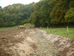
The Doquette in October 2008, after the restoration works.
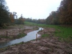
The Doquette in May 2009, seven months after the restoration.
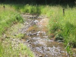
The Doquette after restoration in the summer of 2009. The flows have diversified.
ShowHideAdditionalImage.png


Catchment and subcatchment

Catchment

River basin district Seine-Normandie
River basin sienne

Subcatchment

River name Doquette
Area category
Area (km2)
Maximum altitude category
Maximum altitude (m)
Dominant geology
Ecoregion Western Plains
Dominant land cover agriculture, forest
Waterbody ID


Site

Name Percy
WFD water body codes I70490000
WFD (national) typology
WFD water body name
Pre-project morphology Straight
Reference morphology Single channel, Sinuous
Desired post project morphology
Heavily modified water body true
National/international site designation
Local/regional site designations
Protected species present
Invasive species present
Species of interest
Dominant hydrology Quick run-off, Groundwater
Dominant substrate Gravel
River corridor land use Intensive agriculture
Average bankfull channel width category 2 - 5 m
Average bankfull channel width (m) 2.22.2 m <br />0.0022 km <br />220 cm <br />
Average bankfull channel depth category
Average bankfull channel depth (m)
Mean discharge category
Mean annual discharge (m3/s) 0.050.05 m³/s <br />50 l/s <br />
Average channel gradient category
Average channel gradient 0.0011
Average unit stream power (W/m2) 0.2451750.245 W/m² <br />


Project background

Reach length directly affected (m) 240 m0.24 km <br />24,000 cm <br />
Project started
Works started 2008/10/01
Works completed 2008/10/01
Project completed
Total cost category Less than 10 k€"Less than 10 k€" is not in the list (Less than 1 k€, 1 - 10 k€, 10 - 50 k€, 50 - 100 k€, 100 - 500 k€, 500 - 1000 k€, 1000 - 5000 k€, 5000 - 10000 k€, more than 10000 k€) of allowed values for the "Total cost category" property.
Total cost (k€) 9 k€9,000 € <br />
Benefit to cost ratio
Funding sources Water Agency, Regional Council, Fédération de la Manche pour la pêche et la protection du milieu aquatique

Cost for project phases

Phase cost category cost exact (k€) Lead organisation Contact forename Contact surname
Investigation and design
Stakeholder engagement and communication
Works and works supervision 1 - 10 k€ 9 k€9,000 € <br /> Fédération de la Manche pour la pêche et la protection du milieu aquatique
Post-project management and maintenance
Monitoring


Reasons for river restoration

Mitigation of a pressure
Hydromorphology Structure & condition of riparian zones
Biology
Physico-chemical
Other reasons for the project


Measures

Structural measures
Bank/bed modifications Introducing sediment
Floodplain / River corridor
Planform / Channel pattern Re-instatement of old course, Adding sinuosity
Other
Non-structural measures
Management interventions Promoting riparian vegetation
Social measures (incl. engagement)
Other


Monitoring

Hydromorphological quality elements

Element When monitored Type of monitoring Control site used Result
Before measures After measures Qualitative Quantitative

Biological quality elements

Element When monitored Type of monitoring Control site used Result
Before measures After measures Qualitative Quantitative

Physico-chemical quality elements

Element When monitored Type of monitoring Control site used Result
Before measures After measures Qualitative Quantitative

Any other monitoring, e.g. social, economic

Element When monitored Type of monitoring Control site used Result
Before measures After measures Qualitative Quantitative


Monitoring documents


Additional documents and videos


Additional links and references

Link Description

Supplementary Information

Edit Supplementary Information