Case study:Restoration of the river continuity on the Touques Basin
Project overview
| Status | In progress |
|---|---|
| Project web site | |
| Themes | Flood risk management, Habitat and biodiversity, Hydromorphology |
| Country | France |
| Main contact forename | Yannick |
| Main contact surname | Salaville |
| Main contact user ID | |
| Contact organisation | Fédération de pêche du Calvados |
| Contact organisation web site | http://www.federation-peche14.fr/ |
| Partner organisations | Direction départementale de l’agriculture et de la forêt (DDT), conseil supérieur de la pêche (now National Agency for Water and Aquatic Environments - Onema) |
| Parent multi-site project | |
| This is a parent project encompassing the following projects |
No |
Project summary
Several actions are performed to restore river continuity.
Obstacles (weirs, sluices, dams) are opened,
removed or fitted with fish passes.
Before the first fishway on the Calonne in 1982, some fifteen or so obstacles in the Touques basin had already been dismantled or opened to facilitate flood evacuation. Almost 30 years on, 71 other obstacles have been redeveloped, i.e.:
• 33 weirs removed, lowered or opened including the removal of the Lisieux flap gate dam (implementation: 2007, project owner: commune of Lisieux - see the corresponding example from the collection).
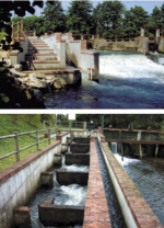
• 38 weirs equipped with fish passes including a
multi-species fishway on the Breuil-en-Auge dam
(implementation: 1999, project owner: Fishing
federation of Calvados) and the development of
4 fish passes on the Cirieux (implementation: 2008,
project owner: commune of Saint-Désir)
As progress has been made, grants received by project owners have supported this programme: The Ministry of the Environment, Conseil supérieur de la pêche (CSP - now Onema), the départements of Calvados, Orne and Eure, the fishing federations of Calvados and Orne, European funds. Currently: the Seine-Normandie and the Region of Basse-Normandie water agency
Monitoring surveys and results
Counting of sea trout travelling upstream at Breuilen-Auge
has been carried out since 2001. This
monitoring is implemented under an agreement
with the owner of the dam and of the fishway.
Reproduction areas accessible to sea trout have increased sharply, thanks to improvements works carried out over the past 30 years. The proportion of accessible surfaces thus increased from 15% before 1982 to 86% in 2009. The sea trout travelling upstream monitored at the Breuil-en-Auge fishway represented 2,500 fish in 2001 and more than 6,000 in 2008, a figure confirmed in 2009 with over 5,500 sea trout. As the monitoring station was located upstream to many tributaries, the current Touques stock is therefore now 10,000 sea trout, making it not only the number one river in France for sea trout but also one of the best in all of Europe. These very good results are accompanied by a significant rise in fishing tourism.
The scale of these actions and their results make the Touques basin a benchmark for continuity in the Seine-Normandie basin.
The Touques axis is completely open to migration, but there are still a dozen or so more obstacles upstream of the tributaries. There are several projects under way. The most penalizing obstacle lies in the middle part of the Calonne. This obstacle, devoid of fish passes despite the regulatory obligations, neutralises the efforts already made upstream in the Eure département due both to the obstruction of upstream fish migration but also damage caused by the turbine on fish returning to the sea.
Lessons learnt
Image gallery
|
Catchment and subcatchment
Site
Project background
Cost for project phases
Reasons for river restoration
Measures
MonitoringHydromorphological quality elements
Biological quality elements
Physico-chemical quality elements
Any other monitoring, e.g. social, economic
Monitoring documents
Additional documents and videos
Additional links and references
Supplementary InformationEdit Supplementary Information
| ||||||||||||||||||||||||||||||||||||||||||||||||||||||||||||||||||||||||||||||||||||||||||||||||||||||||||||||||||||||||||||||||||||||||||||||||||||||||||||||||||||||||||


