Case study:Restoration of the Erft-river in Weilerswist
Project overview
| Status | Complete |
|---|---|
| Project web site | |
| Themes | Economic aspects, Fisheries, Flood risk management, Habitat and biodiversity, Hydromorphology, Monitoring, Spatial planning, Water quality |
| Country | Germany |
| Main contact forename | Volker |
| Main contact surname | Gimmler |
| Main contact user ID | |
| Contact organisation | Erftverband |
| Contact organisation web site | http://www.erftverband.de/ |
| Partner organisations | |
| Parent multi-site project | |
| This is a parent project encompassing the following projects |
No |
Project summary
The Erft River was heavily trained in the 1960s to provide a higher discharge capacity for flood prevention and to make it easier to mechanically maintain the river. High dams were built along the river banks and the river bed was secured with large rocks. This river training resulted in a river with few structures ans a low morphological diversity.
The restoration project has been implemented in Cooperation of the Landesbetrieb Straßen NRW (the state road authority) and the Erftverband (water board in the Erft watershed) to compensate the impact on nature and environment caused by the construction of a new road. The measure has been necessary to reach the Good Ecological State of the Erft required by the WFD. By adressing the need for compensation with a river improvement measure, inefficiencies in public spending has been avoided.
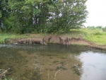
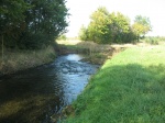
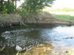
The project started in April 1995 and aimed at developing a structure-rich, ecologically permeable stretch of the river with regularly flooded meadows and a high potential for self-development. About 10 hectares of cropland were bought and turned into a meadow on the left hand side of the river, towards the lowest part of the valley. The dam along the Erft separating this meadow from the river has been removed. The rocks securing the river bed on that side have been removed and groynes have been built in the river bed to add morphological diversity and initiate lateral erosion. The groynes have been designed in cooperation with the local fishery association, and according to their observation, young fish which have been drifted away by floods in the past are now able to stay in the area.
Monitoring surveys and results
Lessons learnt
Image gallery
|
Catchment and subcatchment
Site
Project background
Cost for project phases
Reasons for river restoration
Measures
MonitoringHydromorphological quality elements
Biological quality elements
Physico-chemical quality elements
Any other monitoring, e.g. social, economic
Monitoring documents
Additional documents and videos
Additional links and references
Supplementary InformationEdit Supplementary Information
| |||||||||||||||||||||||||||||||||||||||||||||||||||||||||||||||||||||||||||||||||||||||||||||||||||||||||||||||||||||||||||||||||||||||||||||||||||||||||||||||||||||||||||||||||||||||||||||


