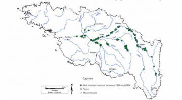
Case study:Restoration of side channels of the Loire and its tributaries
Project overview
| Status | Complete |
|---|---|
| Project web site | |
| Themes | Flood risk management, Habitat and biodiversity, Hydromorphology |
| Country | France |
| Main contact forename | Laëtitia |
| Main contact surname | Boutet-Berry |
| Main contact user ID | |
| Contact organisation | DREAL + FDPPMA, local AAPPMAs, river associations |
| Contact organisation web site | http://http://www.hauts-de-france.developpement-durable.gouv.fr/ |
| Partner organisations | AELB, FDPPMA, Onema (National Agency for Water and Aquatic Environments), regional councils, general councils, associations, regional conservatories of natural areas (CREN), regional conservatory of the banks of the Loire and its tributaries (Corela), departmental territorial directorates (DDTs), regional directorates of the environment, agriculture and housing (DREALs) |
| Parent multi-site project | |
| This is a parent project encompassing the following projects |
No |
Project summary
The plan initiated by the State, Etablissement
public Loire, the Regions and Loire-Bretagne water
agency covers the implementation “of an overall
development plan for the Loire in order to ensure
the safety of the population, protection of the
environment and economic development”.These operations were covered by two different
programmes:
- For sites within the Public River Domain of the Loire and the Allier, operations were primarily carried out as part of the river bed restoration programme, under the guidance and project management of the State;
- For the other tributaries or private land on the banks of the Loire and the Allier, operations were carried out under another chapter of the Plan Loire: the natural environment restoration programme. In this case, the project owners were the departmental ederations for fishing and the protection of the aquatic environment (FDPPMA) or local authorities.
The operations consist in readjusting downstream connecting weirs between the main channel and side channel at the water level exceeded in the spring for 45 days, every fifth year. For pike spawning grounds of the middle Loire, re-connection projects are often positioned near to the water level of the average interannual rate. Given the lowering of the groundwater and lack of maintenance, it is usually necessary to thin the plant cover over old channels to restore sunlight conditions favourable to the development of the herbaceous layer and biological production. The works consist of carefully treating riverside vegetation, while respecting its overall balance, but also its role in the composition of water habitats.
Monitoring surveys and results
Twenty-three side channels underwent a plant and/
or fish diagnostic in 1998 to identify intervention
to be conducted. In accordance with the current
situation and constraints, this preliminary study
resulted in the identification and localisation of
objectives as well as hydraulic requirements of each
intervention.
More comprehensively, multidisciplinary monitoring was carried out on five restored river side channels on the middle Loire.
The physical and chemical features of water were analysed five times a year; the hydraulic operation of each site (floodability / connectivity), and biological factors (invertebrates, zooplankton, fish and vegetation) were monitored and analysed for each area during the 2002 campaign. The monitoring of side channels by the CSP (now Onema), was completed in 2007. Since then, the monitoring measures are taken care by different project owners involved in restoration projects.
Water quality monitoring in the side channels showed the reconnection of some of these areas. Overall, benthic macrofauna is high (138 taxa) and vegetation is fairly homogeneous, dominated by red canarygrass (Phalaris arundinacea).
As far as fish populations are concerned, reproduction has been observed in each of the monitored side channels, but the water deficit in 2002 caused large functional differences between the restored areas, due to their morphological heterogeneity.
In most of the restored sites, egg spawning and the presence of young pike have been highlighted by netting and electrofishing during the breeding season, before the period of migration of juveniles to the main channel.
Lessons learnt
Image gallery
|
Catchment and subcatchment
Site
Project background
Cost for project phases
Reasons for river restoration
Measures
MonitoringHydromorphological quality elements
Biological quality elements
Physico-chemical quality elements
Any other monitoring, e.g. social, economic
Monitoring documents
Additional documents and videos
Additional links and references
Supplementary InformationEdit Supplementary Information
| ||||||||||||||||||||||||||||||||||||||||||||||||||||||||||||||||||||||||||||||||||||||||||||||||||||||||||||||||||||||||||||||||||||||||||||||||||||||||||||||||||||||||||


