Case study:Removal of the Kernansquillec dam over the River Léguer

From RESTORE
Jump to navigation Jump to search
0.00
(0 votes)


To discuss or comment on this case study, please use the discussion page.


Location: 48° 34' 9.61" N, 3° 24' 37.56" W
Loading map...
Left click to look around in the map, and use the wheel of your mouse to zoom in and out.


Project overview

Edit project overview
Status Complete
Project web site
Themes Hydropower
Country France
Main contact forename Catherine
Main contact surname Moret
Main contact user ID
Contact organisation Association de la Vallée du Léguer
Contact organisation web site http://www.riviere-du-leguer.com/
Partner organisations
Parent multi-site project
This is a parent project
encompassing the following
projects
No
This case study hasn’t got a picture, you can add one by editing the project overview.

Project summary

Edit project overview to modify the project summary.


The Léguer is a first-category watercourse, classified as a “river with migratory fish” is one of the region’s most renowned salmon rivers. Between 1920 and 1922, a dam was built across the Léguer in order to supply the Vallée paper mill - one of the biggest factories in the area - with electricity. The dam, approximately 15 metres tall, created a reservoir with a length of approximately 1.5 kilometres. Despite the presence of a fish pass, it was difficult for salmon to cross and this formed an impassable obstacle for eels. In 1965, the paper mill went out of business. The dam then supplied electricity to EDF (French electricity supply ompany). Due to its poor condition, the former licence-holder decided not to renew its application. The dam went into the public domain in 1994.

In addition to the interruption of river continuity, there was significant silting up of the reservoir whose eutrophication was clearly visible. The risk of the dam failing became a growing concern and, due to the lack of maintenance, the Kernansquillec dam started cracking and became a direct threat to homes situated downstream. Following significant flooding in the winter of 1995, the government announced plans to dismantle the dam on the grounds of public safety.

In 1996 the dismantling began with the gradual draining of the reservoir; this drainage process would take five months. 90,000 m³ of sediments were extracted from the orginal river bed. Three 50-centimetre weirs were constructed in order to retain any sediments that might have escaped the suction dredging and reduce the risks of regressive erosion. The dam was then demolished.

Monitoring surveys and results

This case study hasn’t got any Monitoring survey and results, you can add some by editing the project overview.

Lessons learnt

This case study hasn’t got any lessons learnt, you can add some by editing the project overview.


Image gallery


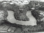
Kernansquillec dam and its reservoir in the last century.
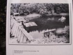
The Kernansquillec dam in 1996 during the pumping out of mud from the reservoir prior to drainage.
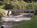
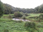
Site of the former dam in October 2009: footbridge and successive weirs.
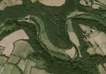
The Léguer valley after the removal of the Kernansquillec dam.
The Léguer within the former reservoir area in October 2009: variations in the stream flow and particle size distribution.
Another view of the Léguer within the former reservoir area in October 2009: variations in the stream flow and particle size distribution.
ShowHideAdditionalImage.png


Catchment and subcatchment

Catchment

River basin district Loire-Bretagne
River basin Léguer

Subcatchment

River name Léguer
Area category 100 - 1000 km²
Area (km2) 280 km²28,000 ha <br />
Maximum altitude category
Maximum altitude (m)
Dominant geology Siliceous
Ecoregion Western Plains
Dominant land cover Extensive agriculture
Waterbody ID


Site

Name Kernansquillec - Plounévez-Moëdec
WFD water body codes FRDR0046
WFD (national) typology
WFD water body name
Pre-project morphology Impounded
Reference morphology Single channel, Sinuous
Desired post project morphology
Heavily modified water body Yes
National/international site designation
Local/regional site designations
Protected species present No
Invasive species present No
Species of interest
Dominant hydrology Artificially regulated
Dominant substrate
River corridor land use Extensive agriculture, Intensive agriculture, Grassland
Average bankfull channel width category 5 - 10 m
Average bankfull channel width (m) 1010 m <br />0.01 km <br />1,000 cm <br />
Average bankfull channel depth category
Average bankfull channel depth (m)
Mean discharge category
Mean annual discharge (m3/s) 66 m³/s <br />6,000 l/s <br />
Average channel gradient category
Average channel gradient
Average unit stream power (W/m2)


Project background

Reach length directly affected (m) 2000 m2 km <br />200,000 cm <br />
Project started 1996/09/01
Works started
Works completed 2001/01/01
Project completed
Total cost category 1000 - 5000 k€
Total cost (k€) 1400 k€1,400,000 € <br />
Benefit to cost ratio
Funding sources French Ministry of Industry, Water Agency, French Ministry of Envinronment, European Community

Cost for project phases

Phase cost category cost exact (k€) Lead organisation Contact forename Contact surname
Investigation and design 10 - 50 k€ 15 k€15,000 € <br />
Stakeholder engagement and communication
Works and works supervision 1000 - 5000 k€ 1400 k€1,400,000 € <br />
Post-project management and maintenance
Monitoring


Reasons for river restoration

Mitigation of a pressure Hydropower, Reservoir impoundment
Hydromorphology Continuity for organisms, Continuity of sediment transport, Quantity & dynamics of flow
Biology Fish: Species composition, Fish: Abundance
Physico-chemical
Other reasons for the project Flood risk management


Measures

Structural measures
Bank/bed modifications Dam removal
Floodplain / River corridor
Planform / Channel pattern Removal of impoundments
Other
Non-structural measures
Management interventions
Social measures (incl. engagement) Rehabilitation of site by local associations, Creation of a centre to show visitors the historical heritage, Creation of a twelve kms foothpath to visit the area, Video made by Eau et Rivières de Bretagne, Brochure available in a website
Other Information provision


Monitoring

Hydromorphological quality elements

Element When monitored Type of monitoring Control site used Result
Before measures After measures Qualitative Quantitative
Continuity for organisms Yes Yes Yes Improvement

Biological quality elements

Element When monitored Type of monitoring Control site used Result
Before measures After measures Qualitative Quantitative
Fish: Species composition Yes Yes Yes Inconclusive

Physico-chemical quality elements

Element When monitored Type of monitoring Control site used Result
Before measures After measures Qualitative Quantitative
[[]] Yes Yes Yes Improvement

Any other monitoring, e.g. social, economic

Element When monitored Type of monitoring Control site used Result
Before measures After measures Qualitative Quantitative


Monitoring documents


Additional documents and videos


Additional links and references

Link Description
http://www.riviere-du-leguer.com/

Supplementary Information

Edit Supplementary Information