Case study:Removal and opening of sluice gates on the Vence River

From RESTORE
Jump to navigation Jump to search
0.00
(0 votes)


To discuss or comment on this case study, please use the discussion page.


Location: 49° 43' 28.91" N, 4° 42' 45.64" E
Loading map...
Left click to look around in the map, and use the wheel of your mouse to zoom in and out.


Project overview

Edit project overview
Status Complete
Project web site
Themes Flood risk management, Habitat and biodiversity
Country France
Main contact forename Grégory
Main contact surname Stéphan
Main contact user ID
Contact organisation Syndicat intercommunal d’études et de travaux pour l’aménagement de la Vence Mairie (SIETAV)
Contact organisation web site
Partner organisations
Parent multi-site project
This is a parent project
encompassing the following
projects
No
This case study hasn’t got a picture, you can add one by editing the project overview.

Project summary

Edit project overview to modify the project summary.


La Vence, 34 Km long, is a tributary of Mouse River. It was modified by the presence of eleven sluice gates, historically used to generate hydropower for artisanal or industrial uses. Nowadays they have lost their original use (with the exception of a micro hydropower still active) and they are used only for water control during low water. The lack of consultation during the sluices gate operations increases the flooding risk. This leads the local institutions - le syndicat intercommunal d’études et de travaux pour l’aménagement de la Vence (SIETAV) et la direction départementale de l’agriculture et de la forêt (DDAF) - to propose adjustments for each of them. Three owners agreed to try it and let the sluice gates open. The valves are held open on two sluice gates and two of them can be removed. Work bank protection and flow diversification are made a few hundred meters upstream and downstream each sluice gate. Baffles, combs and dead wood is placed to diversify flows and limit bank erosion and narrowing of the the riverbed. Willow stakes are placed to recreate a riparian revegetation. This work is done in the traditional way without the use of motorized vehicles in the riverbed.

Monitoring surveys and results

Edit project overview to modify the Monitoring survey and results.


The monitoring show an increase of the habitats diversification especially in terms of flow velocity and depth. Regression for mineral substrates (clogging) in favor of more coarse mineral substrates (favorable for spawning) is observed.

Lessons learnt

This case study hasn’t got any lessons learnt, you can add some by editing the project overview.


Image gallery


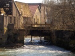
The sluice gate of Saint-Marceau in March 2007, three years after its opening.
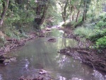
La Vence upstream the sluice gate of St. Ponce in March 2007, after its opening. Artisanal works are placed on the right bank to increase flow diversification.
La Vence upstream the sluice gate of Poix-Terron in September 2009.
The localization of the four sluice gates.
ShowHideAdditionalImage.png


Catchment and subcatchment

Catchment

River basin district Rhin-Meuse
River basin Meuse

Subcatchment

River name La Vence
Area category
Area (km2)
Maximum altitude category
Maximum altitude (m)
Dominant geology
Ecoregion
Dominant land cover
Waterbody ID


Site

Name
WFD water body codes FRB1R578
WFD (national) typology
WFD water body name
Pre-project morphology
Reference morphology
Desired post project morphology
Heavily modified water body No
National/international site designation
Local/regional site designations
Protected species present No
Invasive species present No
Species of interest
Dominant hydrology
Dominant substrate
River corridor land use
Average bankfull channel width category
Average bankfull channel width (m) 33 m <br />0.003 km <br />300 cm <br />
Average bankfull channel depth category
Average bankfull channel depth (m)
Mean discharge category
Mean annual discharge (m3/s) 2.22.2 m³/s <br />2,200 l/s <br />
Average channel gradient category
Average channel gradient 0.15
Average unit stream power (W/m2) 1078.771,078.77 W/m² <br />


Project background

Reach length directly affected (m) 10001,000 m <br />1 km <br />100,000 cm <br />
Project started
Works started 2004/01/01
Works completed 2004/12/31
Project completed
Total cost category
Total cost (k€) 00 k€ <br />0 € <br />
Benefit to cost ratio
Funding sources

Cost for project phases

Phase cost category cost exact (k€) Lead organisation Contact forename Contact surname
Investigation and design
Stakeholder engagement and communication
Works and works supervision
Post-project management and maintenance
Monitoring

Supplementary funding information

No financial investment. The operation took four to five days of work for three agents.


Reasons for river restoration

Mitigation of a pressure Flood risk management
Hydromorphology Quantity & dynamics of flow, Continuity of sediment transport, Continuity for organisms
Biology Fish
Physico-chemical
Other reasons for the project


Measures

Structural measures
Bank/bed modifications sluice gate removal
Floodplain / River corridor
Planform / Channel pattern
Other
Non-structural measures
Management interventions
Social measures (incl. engagement)
Other


Monitoring

Hydromorphological quality elements

Element When monitored Type of monitoring Control site used Result
Before measures After measures Qualitative Quantitative
Substrate conditions No Yes No No No

Biological quality elements

Element When monitored Type of monitoring Control site used Result
Before measures After measures Qualitative Quantitative
Invertebrates No Yes No No No
Fish No Yes No No No

Physico-chemical quality elements

Element When monitored Type of monitoring Control site used Result
Before measures After measures Qualitative Quantitative

Any other monitoring, e.g. social, economic

Element When monitored Type of monitoring Control site used Result
Before measures After measures Qualitative Quantitative


Monitoring documents


Additional documents and videos


Additional links and references

Link Description

Supplementary Information

Edit Supplementary Information