Case study:Remeandering of the Drugeon and integrated management of its catchment
Project overview
| Status | In progress |
|---|---|
| Project web site | |
| Themes | Environmental flows and water resources, Habitat and biodiversity, Water quality |
| Country | France |
| Main contact forename | Jean-Noël |
| Main contact surname | Resch |
| Main contact user ID | |
| Contact organisation | Communauté de communes du plateau de Frasne et du val du Drugeon |
| Contact organisation web site | http://http://www.val-drugeon.org/ |
| Partner organisations | |
| Parent multi-site project | |
| This is a parent project encompassing the following projects |
No |
Project summary
The Drugeon is a 35 km long mid-mountain river, tributary of the Doubs.
Moraine deposits allow the presence of many wetlands .
The Drugeon valley is biologically very rich: 48 species of protected plants including 3 in Europe, 54 species of dragonflies including 4 protected, 80 species of butterflies including 7 protected species, 280 bird species observed (123 nesting ), 3 included in the Habitats directive. Between the late 50s and early 70s, heavy hydraulic works were carried out. Marshes and bogs were drained due the straightening and dredging of the Drugeon and its tributaries. These works, allowing to transform into agricultural land only 200 hectares, reduced by more than 8 km the length of the river and led to riverbed incision, degradation of habitats, warming of water, inducing in its turn algal development. As a result large Plecoptera and freshwater crayfish (Austropotamobius pallipes) totally disappeared and the fish abundance collapsed.
From the 1990s on, awareness of environmental damage by local actors, naturalists, anglers, academics and public officers of the Ministry of Environment allowed the establishment of the " Drugeon valley protection" LIFE project, that was carried out between 1993 and 1997. After this, other restoration works have been implemented in the framework of a multiannual programme.
The main goals of the restoration activity were to restore the morphology and functionality of the Drugeon and its tributaries and to improve their water quality.
Depending on the constraints (land availability, social issues) and main biological goals, different strategies were applied:
• at the sources of Drugeon , measures to diversify the flow by adding roughness;
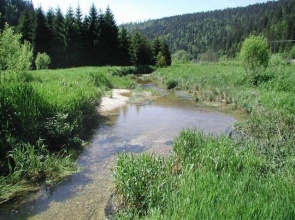
• in the upstream stretch , where the former meanders had been bypassed but not filled, the straightened bed was filled and the meanders reconnected; no bioengineering protection was used, except at intersections between the old meanders and the straightened channel, where willow fascines were installed;
• in the middle stretch , many meanders are reconnected and recreated ; in some cases the straightened channel is filled, in others it remains active, and a hydraulic work splits the water flow between the meander and the straightened channel;
• in the lower Drugeon valley, until the confluence with the Doubs , present land uses did not allow to restore the old river course; however, the section was diversified, with the creation of a high flow and a low flow bed, the latter lined with berms , blocks and groynes; in parallel, river bed recharge with gravel and pebble taken from the former banks was carried out.
Monitoring surveys and results
Since 1997, the restoration works have allowed the recovery of 7 km of meanders and about 300 ha of wetlands and dry grasslands.
The monitoring showed an improvement in habitats quality, although variable depending on the restoration techniques used and on the specific stretches. Anomalies in relation to species distribution suggested impacts due to diffuse chemical pollution (wood processing, rail network ballast, etc.) for which specific measures have been defined. Soon after the works the groundwater table raised by several tens of cm, and later as much as 70 to 80 cm in the upstream and middle Drugeon .
The diversity of the techniques used and the extended monitoring allowed to draw some conclusions about the experience, e.g.: the deepening of meanders must be very limited, it is better to undersize the bed and choose an almost rectangular section, allowing self-adjustments of the bed by the river dynamics ; filling of the straight channel should take into account the compaction of the filling material, in order to avoid that the old channel is reactivated during floods.
The local population is globally satisfied with the results of the project. The budget showed that the cost of restoration was of the same order of magnitude of the expenses for the straightening of the river system.
Since 2003, the site is part of the Ramsar network. In 2004, a prefectural decree issued a protected biotope status on 3,000 hectares of wetlands.
The future restoration measures will be more directed towards the improvement of water quality by treating urban wastewater , renewing networks and controlling agricultural pollution.
Lessons learnt
Image gallery
|
Catchment and subcatchmentSelect a catchment/subcatchment
Catchment
Subcatchment
Site
Project background
Cost for project phases
Reasons for river restoration
Measures
MonitoringHydromorphological quality elements
Biological quality elements
Physico-chemical quality elements
Any other monitoring, e.g. social, economic
Monitoring documents
Additional documents and videos
Additional links and references
Supplementary InformationEdit Supplementary Information
| |||||||||||||||||||||||||||||||||||||||||||||||||||||||||||||||||||||||||||||||||||||||||||||||||||||||||||||||||||||||||||||||||||||||||||||||||||||||||||||||||||||||||||||||||||||||||||||||||||||||||||||||||||||||||||||||||||||||||||


