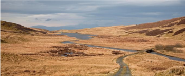
Case study:Pumlumon Peatland Restoration for Floodwater Management
Project overview
| Status | In progress |
|---|---|
| Project web site | http://www.therrc.co.uk/sites/default/files/projects/37_pumlumon.pdf |
| Themes | Flood risk management, Habitat and biodiversity, Land use management - agriculture, Peat, Water quality |
| Country | Wales |
| Main contact forename | Liz |
| Main contact surname | Montgomeryshire Wildlife Trust |
| Main contact user ID | |
| Contact organisation | Montgomeryshire Wildlife Trust |
| Contact organisation web site | http://www.montwt.co.uk/ |
| Partner organisations | Bangor University, Cambrian Mountains Initiative, Centre for Ecology & Hydrology, Ceredigion County Council, Communities First Mahynlleth, Defra, Dyfi Biosphere, Ecodyfi and Pentir Pumlumon, Leeds University, Natural Resources Wales, Powys County Council, RSPB, Welsh Government |
| Parent multi-site project | |
| This is a parent project encompassing the following projects |
No |
Project summary
The Montgomeryshire Wildlife Trust has been running the Pumlumon Living Landscape Project (Photo 1 and Map 1) since 2005, during which time it has developed and demonstrated the benefits of an ecosystem approach to landscape, people, the economy and wildlife. Rewetting upland peat bogs, through the blocking of drainage ditches, improves their condition and water retention capability, creates new areas for wildlife, and helps reduce climate affecting emissions. The Pumlumon project recognises that the future for upland farming is threatened; however, there is also awareness that the uplands of Wales offer vital economic opportunities both in terms of carbon and floodwater.
- The Pumlumon Living Landscape Project has identified a number of ditch blocking methods to support floodwater management works across of range of sites.
- The capital works cost to carry out effective flood water management techniques on degraded bog is minimal. However, it represents a potentially valuable economic opportunity for upland landowners.
- The data collected to date have been analysed by CEH Wallingford. The hydrological restoration carried out on Glaslyn has raised the water table by 5cm.
Monitoring surveys and results
Lessons learnt
Image gallery
|
Catchment and subcatchment
Site
Project background
Cost for project phases
Reasons for river restoration
Measures
MonitoringHydromorphological quality elements
Biological quality elements
Physico-chemical quality elements
Any other monitoring, e.g. social, economic
Monitoring documents
Additional documents and videos
Additional links and references
Supplementary InformationEdit Supplementary Information
| ||||||||||||||||||||||||||||||||||||||||||||||||||||||||||||||||||||||||||||||||||||||||||||||||||||||||||||||||||||||||||||||||||||||||||||||||||||||||||||||||||||||||||||||||||

