Case study:Newe Fish Pass Improvements project
Project overview
| Status | Complete |
|---|---|
| Project web site | |
| Themes | Fisheries |
| Country | Scotland |
| Main contact forename | Jamie |
| Main contact surname | Urquhart |
| Main contact user ID | |
| Contact organisation | The River Don Trust |
| Contact organisation web site | http://www.riverdon.org.uk/ |
| Partner organisations | |
| Parent multi-site project | |
| This is a parent project encompassing the following projects |
No |
Project summary
Background
The River Don Trust has undertaken a number of obstacle assessments across the catchment over the past year. One of these sites surveyed was the Fish Pass on the Newe weir. The fish pass was created back in the 1950’s when the old hydro power scheme was in use at the site. Whilst there has been some remedial works to the weir itself over the years by its owners the Fishery Board there has never been any formal action taken to assess or improve the fish pass.
The fish pass is known to function properly otherwise the 200km of tributaries and mainstem upstream would be devoid of salmon which is far from the case. However it is evident that the structure under certain flow conditions can delay fish migration. Following a survey at the site it was deemed appropriate that where possible we should begin with a series of improvements to the structure to reduce the delay associated with it for upstream migrating salmonids. From previous discussions it was apparent that minor alterations to the pass would both be acceptable and achievable by those concerned.
Methods
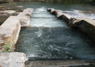
This first improvement was focused upon reducing the turbulence associated with the boxes and reducing the pluming of water as it leaves the face of the notch in each box of the pass. In order to achieve this the Trust biologist researched information relating to these factors and found evidence to support the creation of an ‘adherent nappe’ on each notch.
The current design of the fish pass structure has square edged notches between each box. When water flows of a square edge at force it plumes and creates a gap between the water and the surface of the structure itself (think of a waterfall). This gap created is also known as an “aerated nappe”.
An aerated nappe prevents fish from swimming up and through the plume and causes them to have to jump. Fish are essentially designed to swim, and while they can clearly jump, especially salmonids, a jumping fish is a sign that they are in difficulty. To surmount an obstacle successfully a jumping fish has to locate the right spot from which to jump, get its trajectory correct, land safely, and be pointing in a direction that enables it to succeed in swimming away upstream. Jumping is thus uncertain advertises the fish’s presence to predators, risking collision damage with structures, with high risk of failure to achieve the correct height and trajectory, and with every risk of being swept back downstream if it does not land with head pointing upstream (because of the large forces on its side if it is in any way across the flow).
Aerated nappes, especially on fish pass notches, must therefore be avoided in favor of adherent nappes where the water flows over the structure smoothly without leaving its surface creating a swim obstacle as opposed to a jump. Therefore adherent nappes will be created at the Newe Fish Pass by cutting angled sections of the concrete from the squared edge notches at the bottom of each box. The Trust biologist prepared the following design using measurements modified to suit the dimensions of the Newe Fish Pass from the Environment Agency Fish Pass Guidance Manual (2010).
Monitoring surveys and results
Some monitoring of the pass will enable the Board and Trust to ascertain if the remedial works have proved to be effective. If feasible the River Don Trust hope to use an underwater camera to ascertain if fish are passing though the pass under a wide range of flows.
Lessons learnt
It was apparent that the bottom box may still cause problems for ascending fish due to the distance between the pool and the bottom of the box presented by an apron extending out some 1.05m under the water which could restrict fish from jumping into the box under certain flow conditions. Further work will investigate options to alleviate any problems associated with this part of the structure.
Image gallery
|
Catchment and subcatchment
Site
Project background
Cost for project phases
Reasons for river restoration
Measures
MonitoringHydromorphological quality elements
Biological quality elements
Physico-chemical quality elements
Any other monitoring, e.g. social, economic
Monitoring documents
Additional documents and videos
Additional links and references
Supplementary InformationEdit Supplementary Information
| ||||||||||||||||||||||||||||||||||||||||||||||||||||||||||||||||||||||||||||||||||||||||||||||||||||||||||||||||||||||||||||||||||||||||||||||||||||||||||||||||||||||||||||||||||||

