Case study:Dumbreck Marsh & Garrel Burn Restoration
Project overview
| Status | Complete |
|---|---|
| Project web site | |
| Themes | Environmental flows and water resources, Fisheries, Habitat and biodiversity, Hydromorphology, Social benefits, Urban |
| Country | Scotland |
| Main contact forename | Francis |
| Main contact surname | Hayes |
| Main contact user ID | User:Francis Hayes |
| Contact organisation | SEPA |
| Contact organisation web site | http://www.sepa.org.uk/ |
| Partner organisations | North Lanarkshire Council, SEPA, Scottish Government, Clyde River Foundation |
| Parent multi-site project | |
| This is a parent project encompassing the following projects |
No |
Project summary
Dumbreck Marsh is a ‘brownfield’ wetland area which developed naturally on post-industrial land in the mid/late 20th Century. The area was once heavily used for colliery activities and mineral railways. After the decline of the colliery industries the land was left fallow and gradually accommodated wetland habitats and associated species – eventually including the endangered lapwing? – it also became a valued area for greenspace, public access, and wildlife for the local Kilsyth community and was designated as a Local Nature Reserve by North Lanarkshire Council in…19…. Recently the marsh has suffered drying out and loss of wildlife, with access routes becoming eroded and therefore limiting public access.
Historical mapping shows the Garrel Burn was straightened into an entrenched channel over 250 years during either 17th or 18th century creating simplified channel lacking in morphological diversity and subsequently habitat complexity while also disconnecting it from its floodplain at Dumbreck. Continually dredging of the channel and embankment construction resulted in greater levels of incision and floodplain disconnection. Further to this, two weirs located within the river at Kilsyth prevented access to over 1.5 km of quality upstream habitat to migrating fish (eel, trout, salmon, lamprey).
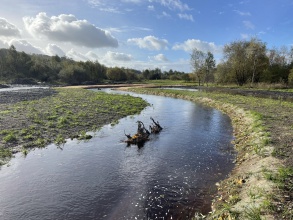
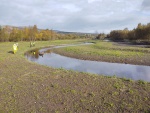
By restoring around 600m of the burn to a more natural lowland meandering planform, with a wider and shallower channel displaying gravel bars and pool features, the river will be able to accommodate a greater variety of wildlife and provide more attractive fish habitat. The channel also now allows the Garrel Burn to naturally flood into the wetland zone to help recharge the marsh with water. Two weirs have had “pre-weir” fish ladders built below them to allow migrating fish to, once again, reach the upstream habitat available to them in Kilsyth.
Public access has been substantially improved with new pathways and resurfacing of existing popular routes. Three new attractive footbridges also enhance the experience of the riverside for the public. The paths at Dumbreck contain a variety of options for public enjoyment including short circular walks, and connectivity with other networks including the John Muir Way. Further community and visitor engagement and improved interpretation of the sites industrial and natural heritage is an ongoing part of the strategy for the Council.
The Dumbreck Marsh where enhancements have taken place covers an area of around 70 hectares.
The length of Garrel Burn enhanced by the work is 1 km. Around 600 m of a new meandering channel has been created through Dumbreck Marsh. The whole length of the river (1km) has had INNS (Japanese knotweed and Himalayan Balsam) eradicated, with existing banks re-profiled and seeded.
Fish (salmon, trout, eel and lamprey) have access to the improved river (1km), and also with new fish ladders built on the two weirs at the upstream end of the works, fish now have access to 1.5km of river habitat within Kilsyth.
- Over 2km of footpaths have been restore, along with 3 new footbridges and a board walk for public access.
- Habitat enhancements – scrapes, bird boxes, sand martin wall, woody structures placed in channel for habitat and channel form.
- Disabled car parking improved.
- Further tree planting planned with community volunteers in 2022.
- Ongoing engagement with local communities will be led by North Lanarkshire Council for greenspace access and local heritage.
Monitoring surveys and results
Work completed in April 2022. To date the Clyde River Foundation undertook monitoring before and during works and have found all key fish species in the area - lamprey, trout, eel and salmon. We hope to see these species thriving in future years.
Lessons learnt
Complex "post industrial" zones, despite appearing to be greenspace can be complex locations to undertake engineering due to subsurface utilities, contaminants and historic refuse material. However by careful design and management natural river form and function can be achieved providing more resilience for the river and its wildlife.
Image gallery
|
Catchment and subcatchment
Site
Project background
Cost for project phases
Reasons for river restoration
Measures
MonitoringHydromorphological quality elements
Biological quality elements
Physico-chemical quality elements
Any other monitoring, e.g. social, economic
Monitoring documents
Additional documents and videos
Additional links and references
Supplementary InformationEdit Supplementary Information
| ||||||||||||||||||||||||||||||||||||||||||||||||||||||||||||||||||||||||||||||||||||||||||||||||||||||||||||||||||||||||||||||||||||||||||||||||||||||||||||||||||||||||


