Case study:Removal of the pont Paillard weir on a secondary arm of the Aume
Project overview
| Status | Complete |
|---|---|
| Project web site | |
| Themes | Flood risk management, Hydromorphology, Monitoring |
| Country | France |
| Main contact forename | Julien |
| Main contact surname | Blancant |
| Main contact user ID | |
| Contact organisation | Syndicat intercommunal d’aménagement hydraulique du bassin Aume - Couture |
| Contact organisation web site | |
| Partner organisations | |
| Parent multi-site project | |
| This is a parent project encompassing the following projects |
No |
Project summary
The Aume is a 32 km long tributary of the Charente. It has great potential for eel, sea trout and brown trout. Its watershed is primarily agricultural.
The Aume has undergone many morphological alterations. Between 1960 and 1995, the river was straightened, dredged and its cross-section modified in order to drain the marshes and make the cultivation of corn possible. This caused riverbed incision and lowering of the groundwater table. In order to try to stop this process raising the water level a series of 20 weirs made with planks was built.
However, they caused silting, favoured eutrophication and induced longitudinal fragmentation.
The plank weirs are kept open during the winter (October 15 to early May), except for the pont Paillard one, which had remain closed for ten years.
The “Syndicat de rivière intercommunal d’aménagement hydraulique du bassin de l’Aume – SIAHBAC” (grouping of local administrations for the hydraulic management of the Aume basin) is the owner and manager of all of these works. As part of the new strategy of SIAHBAC, which aims to meet the objectives of the Water Framework Directive, it was decided to test the removal of planks at the pont Paillard site.
The objectives of the action were to restore ecological continuity (for fish and sediment) and a more natural flow regime; moreover, to educate local stakeholders in this type of operation, to promote further restoration activities.
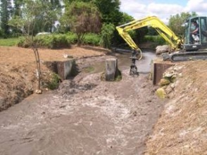
The work, on a secondary, disconnected arm of the Aume, consisted in the mere removal of the wooden planks of the weir, entailing practically no costs. The concrete structure is retained, in order to make the measure reversible in case of failure (not all the farmers supported it). No planting or any other action in the riverbed was performed, in order to follow the natural evolution of the river.
Monitoring surveys and results
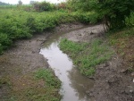
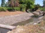
Unfortunately no baseline was established before the measure was implemented and so far only a photographic monitoring was carried out, therefore environmental benefits cannot be quantified. However, a reduction of eutrophication was experienced, vegetation quickly recolonized the banks and the bed granulometry became more heterogeneous.
A quantitative monitoring is foreseen, especially of the river morphology and of the groundwater level. A quantitative assessment will support the implementation of similar actions in other sites using the same approach.
Lessons learnt
Image gallery
|
Catchment and subcatchmentSelect a catchment/subcatchment
Catchment
Subcatchment
Site
Project background
Cost for project phases
Reasons for river restoration
Measures
MonitoringHydromorphological quality elements
Biological quality elements
Physico-chemical quality elements
Any other monitoring, e.g. social, economic
Monitoring documents
Additional documents and videos
Additional links and references
Supplementary InformationEdit Supplementary Information
| ||||||||||||||||||||||||||||||||||||||||||||||||||||||||||||||||||||||||||||||||||||||||||||||||||||||||||||||||||||||||||||||||||||||||||||||||||||||||||||||||||||||||||||||||||||||||||||||||||||||||||||


