Case study:Lower Aurino river: Gatzaue riverbed widening
This case study is pending approval by a RiverWiki administrator.
Project overview
| Status | Complete |
|---|---|
| Project web site | |
| Themes | Flood risk management, Habitat and biodiversity, Hydromorphology, Social benefits, Spatial planning |
| Country | Italy |
| Main contact forename | Caterina |
| Main contact surname | Ghiraldo |
| Main contact user ID | |
| Contact organisation | Provincia Autonoma di Bolzano |
| Contact organisation web site | |
| Partner organisations | |
| This is a parent project encompassing the following projects |
Project summary
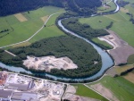
The Aurino river is a typical Alpine watercourse (basin Area 630 km2, average discharge in summer 30-50 m3/s) subject in the past to a radical channalization (riparap) which reduced significantly the width of the riverbed and the morphological structures and dynamics and which caused a general riverbed lowering and the lost of the connection with the floodplain. In the same time the groundwater lowering caused a loss of the hygrophilous riparian forests (Alnus incana).
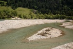
The riverbed widening of Aurino river in Gatzaue was planned mainly to increase the biodiversity and to invert the riverbed and grounwater lowering process. The work was executed by removing a total of 25.000 m3 of gravel from the disconnected floodplain obtaining a total riverbed windening of 35 m; in the same time the riverbed was reshaped (also by inserting big stones and woody debris and creating new branches) to give it a more natural structure. A monitoring activity was implemented to study the geomorphological and biological effects of the project.
Monitoring surveys and results
Lessons learnt
Catchment and subcatchment
Site
| Name | Gatzaue |
|---|---|
| WFD water body codes | 03SS3N |
| WFD (national) typology | |
| WFD water body name | D_c Torrente Aurino |
| Pre-project morphology | Single channel |
| Reference morphology | Braided |
| Desired post project morphology | |
| Heavily modified water body | No |
| National/international site designation | |
| Local/regional site designations | |
| Protected species present | No |
| Invasive species present | No |
| Species of interest | |
| Dominant hydrology | Artificially regulated |
| Dominant substrate | Bedrock |
| River corridor land use | Grassland |
| Average bankfull channel width category | 10 - 50 m |
| Average bankfull channel width (m) | |
| Average bankfull channel depth category | 0.5 - 2 m |
| Average bankfull channel depth (m) | |
| Mean discharge category | 10 - 100 m³/s |
| Mean annual discharge (m3/s) | |
| Average channel gradient category | |
| Average channel gradient | |
| Average unit stream power (W/m2) |
Project background
| Reach length directly affected (m) | |
|---|---|
| Project started | 2003 |
| Works started | |
| Works completed | 2011/01/04 |
| Project completed | |
| Total cost category | |
| Total cost (k€) | |
| Benefit to cost ratio | |
| Funding sources |
Cost for project phases
| Phase | cost category | cost exact (k€) | Lead organisation | Contact forename | Contact surname |
|---|---|---|---|---|---|
| Investigation and design | |||||
| Stakeholder engagement and communication | |||||
| Works and works supervision | |||||
| Post-project management and maintenance | |||||
| Monitoring |
Reasons for river restoration
Measures
Structural measures
| |
|---|---|
| Bank/bed modifications | Riverbed widening, creation of new branches |
| Floodplain / River corridor | Floodplain reconnection |
| Planform / Channel pattern | creation of new natural channels |
| Other | Creation of new lateral habitat for fishes, amphibians and birds (alcedo atthis) |
Non-structural measures
| |
| Management interventions | |
| Social measures (incl. engagement) | Citizen participation in the restoration project |
| Other | |
Monitoring
Hydromorphological quality elements
| Element | When monitored | Type of monitoring | Control site used | Result | ||
|---|---|---|---|---|---|---|
| Before measures | After measures | Qualitative | Quantitative | |||
| Channel pattern/planform | No | Yes | Yes | No | Yes | Improvement |
| Connection to groundwaters | Yes | Yes | No | Yes | No | Improvement |
| Structure & condition of riparian/lake shore zones | No | Yes | No | No | No | Improvement |
Biological quality elements
| Element | When monitored | Type of monitoring | Control site used | Result | ||
|---|---|---|---|---|---|---|
| Before measures | After measures | Qualitative | Quantitative | |||
| Invertebrates | No | Yes | No | Yes | Yes | Awaiting results |
Physico-chemical quality elements
| Element | When monitored | Type of monitoring | Control site used | Result | ||
|---|---|---|---|---|---|---|
| Before measures | After measures | Qualitative | Quantitative | |||
Any other monitoring, e.g. social, economic
| Element | When monitored | Type of monitoring | Control site used | Result | ||
|---|---|---|---|---|---|---|
| Before measures | After measures | Qualitative | Quantitative | |||
| Riparian vegetation | No | Yes | Yes | No | No | No change |
Monitoring documents
Image gallery
Additional documents and videos
Additional links and references
| Link | Description |
|---|
Supplementary Information
Edit Supplementary Information


