Case study:Afon Merin Natural Process Restoration
This case study is pending approval by a RiverWiki administrator.
Project overview
| Status | Complete |
|---|---|
| Project web site | http://westwalesriverstrust.org/the-human-beaver/ |
| Themes | Environmental flows and water resources, Fisheries, Flood risk management, Habitat and biodiversity, Hydromorphology, Land use management - forestry, Monitoring, Water quality |
| Country | Wales |
| Main contact forename | Ieuan |
| Main contact surname | Davies |
| Main contact user ID | User:Ieuan |
| Contact organisation | Natural Resources Wales |
| Contact organisation web site | http://naturalresources.wales/?lang=en |
| Partner organisations | |
| This is a parent project encompassing the following projects |
Project summary
The Afon Merin is one of the principal tributaries of the Rheidol system, flowing from its upland SSSI catchment, through NRW managed Welsh Government estate Myherin woodland and onwards into the Rheidol Valley. A 3km section provided landscape scale intervention opportunities to "kick-start" natural processes to benefit biodiversity, water quality and quantity, and carbon sequestration.
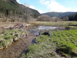
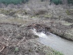
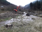
The site offered the potential to undertake a pilot study of low cost high nature value interventions on Welsh Government Woodland Estate. While seemingly in a natural state, the rivers was incised and disconnected from the wider flood plain, with a lack of suitable gravels for the resident native Brown Trout population. Felling commenced in 2018 and some of the timber was used to begin ditch blocking and creating leaky dams within the main channel. Early observations showed that the results had been positive with the hydrological systems soon renaturalising within the valley floor, wet areas were developing and the main channel began to take on a more braided characteristic by occupying historic channels. In channel flow diversity increased markedly allowing a more complex sediment matrix to appear.
Monitoring surveys and results
Water immediately started to spill out of bank picking up a network of relict channels within the floodplain. Subsequent high flow events have seen gravel depositing instream and as shoals, more dynamic flow patterns and a complex of side channels, permanent and temporary pond features.
Prework aerial studies of the area and fixed point photography at key areas through the valley have allowed a gross study of early geomorphological changes within the system, including stream number and width, and changes within the network of wet areas across the valley floor.
Aberystwyth University are undertaking flow measurements and will continue to do so over an extended time period. Ecological studies will be undertaken across this and a control site on the same water body to monitor changes.
Lessons learnt
The implementation of this scheme on Welsh Government Woodland Estate has shown that there are high value gains possible at low cost inputs which can be imnplemented alongside current Forest management techniques. These can yield multiple benefits and studying these allows us to put forward a case for spreading this work and ethos across the wider Woodland Estate with potential for large scale projects. The multiple benefits are closely aligned with NRW's wider Corporate and Business plans and better ways of working which look to generate positive outcomes through nature based solutions giving positive benefits across a broad spectrum of habitats, species and communities.
Image gallery
|
Catchment and subcatchmentSelect a catchment/subcatchment
Catchment
Subcatchment
Site
Project background
Cost for project phases
Supplementary funding informationTotal project cost including felling and installation of dams and scrapes was approximately £30,000
Reasons for river restoration
Measures
MonitoringHydromorphological quality elements
Biological quality elements
Physico-chemical quality elements
Any other monitoring, e.g. social, economic
Monitoring documents
Additional documents and videos
Additional links and references
Supplementary InformationEdit Supplementary Information Historical maps showed a more dynamic river system prior to agriculture, conifer afforestation and land drainage in the catchment. The river had cut down into its bed, severing it from its floodplain on all but extreme events. Gravels had been scoured out of large areas of the watercourse leaving a cobble substrate sub-optimal for spawning salmonids. Significant lengths of the river were also dry during the extended dry spell in summer of 2018. The project commenced in early 2018 with felling of conifer, ditch blocking and instream structures to wet up the site and re-link the river to the floodplain and then the installation of 15 leaky dams and scrapes.
| ||||||||||||||||||||||||||||||||||||||||||||||||||||||||||||||||||||||||||||||||||||||||||||||||||||||||||||||||||||||||||||||||||||||||||||||||||||||||||||||||||||||||||||||||||||||||||||||||||||||||||


