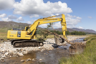
Case study:River Calder Large Wood Structure installation
This case study is pending approval by a RiverWiki administrator.
Project overview
| Status | Complete |
|---|---|
| Project web site | |
| Themes | Fisheries, Flood risk management, Habitat and biodiversity, Hydromorphology |
| Country | Scotland |
| Main contact forename | Penny |
| Main contact surname | Lawson |
| Main contact user ID | User:Penny Lawson |
| Contact organisation | |
| Contact organisation web site | http://www.speycatchment.org |
| Partner organisations | Spey Fishery Board, SEPA, Pitmain and Glenbanchor Estates, Cluny Estate |
| Parent multi-site project | |
| This is a parent project encompassing the following projects |
No |
Project summary
With funding from the Scottish Environment Protection Agency (SEPA), the Spey Catchment Initiative took measures to improve habitat for fish and other aquatic biodiversity in the River Calder near Newtonmore. Poor salmonid juvenile productivity had been linked to sub-optimal substrate and sediment processes. As there is very little riparian woodland along the river, Large Wood Structures (LWS) were installed to mimic natural dead wood and kickstart hydro-morphological processes to increase natural erosion and deposition, encouraging formation of higher quality, more diverse habitats in the channel and potentially providing water quality enhancements.
During August 2020 a total of 29 structures formed from locally harvested, whole trees from a nearby windblown plantation, were secured into the river bed or banks at carefully chosen locations along approximately 1.6 km of the Calder. Medial and bar apex structures were constructed where the river was showing signs of partially formed features. Cbec eco-engineering were contracted to do the initial survey and design, and local contractors G Campbell did the groundworks.
To make the improvements sustainable in the long term, the Spey Catchment Initiative is also creating over 22ha of new riparian woodland covering both banks and encompassing the LWS reach and an area further upstream. Low density planting of native species and anticipated regeneration will hopefully ensure an on-going natural source of dead wood input, as well as providing habitat and NFM benefits.
Monitoring surveys and results
Baseline monitoring already carried out includes ground-based and aerial photographic surveys, timelapse photography of one LWS, drone topographic survey, macro-invertebrate survey, electro-fishing and salmonid redd counts. Water temperature loggers have been installed upstream and downstream of the project reach.
The surveys will be repeated at appropriate intervals. The redd survey done in November 2020 revealed new salmon redds associated with 12 of the structures - a very promising early result.
Lessons learnt
Image gallery
|
Catchment and subcatchmentSelect a catchment/subcatchment
Catchment
Subcatchment
Site
Project background
Cost for project phases
Reasons for river restoration
Measures
MonitoringHydromorphological quality elements
Biological quality elements
Physico-chemical quality elements
Any other monitoring, e.g. social, economic
Monitoring documents
Additional documents and videos
Additional links and references
Supplementary InformationEdit Supplementary Information
| ||||||||||||||||||||||||||||||||||||||||||||||||||||||||||||||||||||||||||||||||||||||||||||||||||||||||||||||||||||||||||||||||||||||||||||||||||||||||||||||||||||||||||||||||||||||||||||||||||||||||

