Case study:Restoration of the Cassaire wetland (Rhôle delta)

From RESTORE
Revision as of 12:34, 25 February 2020 by Alexrrc (talk | contribs)
(diff) ← Older revision | Latest revision (diff) | Newer revision → (diff)
Jump to navigation Jump to search
0.00
(0 votes)


To discuss or comment on this case study, please use the discussion page.


Location: 43° 32' 27.49" N, 4° 47' 53.09" E
Loading map...
Left click to look around in the map, and use the wheel of your mouse to zoom in and out.


Project overview

Edit project overview
Status Complete
Project web site
Themes Habitat and biodiversity, Social benefits
Country France
Main contact forename Jean-Laurent
Main contact surname Lucchesi
Main contact user ID
Contact organisation
Contact organisation web site
Partner organisations
Parent multi-site project
This is a parent project
encompassing the following
projects
No
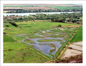
Cassaire site two years after the beginning of the hydraulic management.

Project summary

Edit project overview to modify the project summary.


The project aims to restore an agricultural waste land in a wetland by installing typical temporary marshes and grassland vegetations of Mediterranean wetlands. The aim is also to show that the development of hunting activity is compatible with a hydraulic management respecting the natural cycle of a mediterranean temporary marsh. Various developments have been carried out on the site such as earthworks, sediment transfers for reference ecosytems and the installation of a pumping station powered by a wind turbine. This pumping station helps maintain a favorable water level for aquatic habitats and waterbirds. Horse grazing from February to August helps to maintain vegetations open.

Monitoring surveys and results

Edit project overview to modify the Monitoring survey and results.


Monitoring: - vegetation dynamics and dynamics of the seed bank - transport of seeds (wind, water) - birds - counting of hunting tables - hydrology The former agricultural fields have been restored as temporary marshes and Mediterranean grasslands. The three objectives pursued have been globally achieved - Ecological: increase of the heritage interest of the site - Sociological: development of hunting activities for the inhabitants of the nearby hamlet - Scientific: progress of knowledge in ecology of restoration Main results: - reclamation of a wetland destroyed by cultivation activities in the middle of the 20th century By: - the development of target plant communities according to hydrological conditions - the installation of protected but not targeted species

Lessons learnt

Edit project overview to modify the lessons learnt.


The need to precisely control the management (hydraulic management and grazing): - breeders do not strictly respect the demands of the managers (grazing period and grazing pressure) - capcity of the pumping staition inferior to that announced by the manufacturer The need to organize from the beginning: - the monitoring at mid and long terms - the means to ensure adaptive management in order to respond to the possible gap between the vegetation obtained and those predicted. - The need to raise awareness (breeders, hunters) that a more environmentally friendly environment offers more irregular services than a area only managed for a particular service


Image gallery


Cassaire site two years after the beginning of the hydraulic management
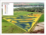
Modeling of the targeted topography to achieved the desired hydraulic conditions
ShowHideAdditionalImage.png


Catchment and subcatchment

Catchment

River basin district Rhône - Méditerranée
River basin Rhône-Mediterranean

Subcatchment

River name Verdier marshes
Area category Less than 10 km²
Area (km2)
Maximum altitude category
Maximum altitude (m)
Dominant geology
Ecoregion
Dominant land cover Coastal wetlands and lagoons
Waterbody ID


Other case studies in this subcatchment: INTERREG MED WETNET - Membership card of the Verdier Marshes-Rhone Delta Wetland Contract, MediCyn, The Verdier marshes


Site

Name Cassaïre
WFD water body codes
WFD (national) typology
WFD water body name
Pre-project morphology Rice field
Reference morphology Temporary marsh
Desired post project morphology Temporary marsh with various depth
Heavily modified water body No
National/international site designation
Local/regional site designations
Protected species present Yes
Invasive species present Yes
Species of interest native or typical flora of the temporary wetlands of the Camargue area, adapted to the Mediterranean climate, with protection status and threatened by some types of water management, such as fresh waterproduction in the summer (Callitriche sp., Callitriche truncata, Chara aspera, Characanescens, Chara globularis, Ranunculus peltatus, Ranunculus trichophyllus, Tolypella glomerata, Tolypella hispanica, Zannichellia obtusifolia and Zannichellia pedicellata).
Dominant hydrology Temporary flooding
Dominant substrate Clay and sand
River corridor land use
Average bankfull channel width category
Average bankfull channel width (m)
Average bankfull channel depth category
Average bankfull channel depth (m)
Mean discharge category
Mean annual discharge (m3/s)
Average channel gradient category
Average channel gradient
Average unit stream power (W/m2)


Project background

Reach length directly affected (m)
Project started 01/01/2010
Works started
Works completed
Project completed
Total cost category
Total cost (k€)
Benefit to cost ratio
Funding sources

Cost for project phases

Phase cost category cost exact (k€) Lead organisation Contact forename Contact surname
Investigation and design
Stakeholder engagement and communication
Works and works supervision
Post-project management and maintenance
Monitoring


Reasons for river restoration

Mitigation of a pressure
Hydromorphology
Biology
Physico-chemical
Other reasons for the project Landscape enhancement


Measures

Structural measures
Bank/bed modifications
Floodplain / River corridor Installing typical temporary marshes and grassland vegetations of Mediterranean wetlands.
Planform / Channel pattern
Other Installation of a pumping station powered by a wind turbine.
Non-structural measures
Management interventions Hydraulic management and grazing; Horse grazing from February to August helps to maintain vegetations open; Monitoring
Social measures (incl. engagement)
Other


Monitoring

Hydromorphological quality elements

Element When monitored Type of monitoring Control site used Result
Before measures After measures Qualitative Quantitative

Biological quality elements

Element When monitored Type of monitoring Control site used Result
Before measures After measures Qualitative Quantitative

Physico-chemical quality elements

Element When monitored Type of monitoring Control site used Result
Before measures After measures Qualitative Quantitative

Any other monitoring, e.g. social, economic

Element When monitored Type of monitoring Control site used Result
Before measures After measures Qualitative Quantitative


Monitoring documents


Additional documents and videos


Additional links and references

Link Description

Supplementary Information

Edit Supplementary Information