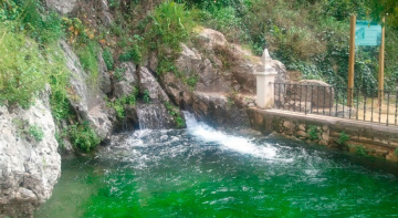
Case study:Updated project for the “Environmental Restoration and Urban and Landscape Planning of Cabra River’s High Section (Cordoba)

From RESTORE
Revision as of 15:15, 12 December 2019 by Wetnet (talk | contribs)
Jump to navigation Jump to search

This case study is pending approval by a RiverWiki administrator.

Approve case study


0.00
(0 votes)


To discuss or comment on this case study, please use the discussion page.


Location: 37° 27' 58.78" N, 4° 31' 47.16" W
Loading map...
Left click to look around in the map, and use the wheel of your mouse to zoom in and out.


Project overview

Edit project overview
Status In progress
Project web site http://www.chguadalquivir.es/inicio
Themes Social benefits, Spatial planning
Country Spain
Main contact forename Maria Jesus
Main contact surname Castañeda
Main contact user ID
Contact organisation Guadalquivir Hydrographic Confederation. Ministry for Ecological Transition.
Contact organisation web site http://www.chguadalquivir.es/inicio
Partner organisations
Parent multi-site project
This is a parent project
encompassing the following
projects
No
Project picture

Project summary

Edit project overview to modify the project summary.


The river Cabra is under strong agricultural and urban pressure, with a very fragmented landscape whose main uses, are not only urban, but also industrial and agricultural (greenhouses and crops such as olive groves and orchards).Therefore, this upper section of the river suffers from various kinds problems. Among them are the spillings and waste accumulation, the loss of water quality, erosion and destabilization of the riverbed and its banks, a serious degradation of vegetation and the absolute disconnection of the fluvial environment and the urban, agricultural and industrial environment.

Even so, there is a there is still a wealth of flora and fauna in its banks, real and potential, and a public demand for the protection, conservation and enhancement of the natural resources associated with the urban section of the river Cabra, by both the Cabra City Coucil and local citizens associationes. Hence, the project aims to improve the landscape and aesthetics of the area (by cleaning and removal of waste), to restore and improve the natural environment (with silvicultural treatments of riverside vegetation and plantations) and to carry out hydrological recovery actions, such as stabilization of slopes and recovery of margins witch present erosion problems. In this regard, the project proposes planting of autochthonous vegetation (elms, poplars, ashes, willows, tarajes, figs ...) along the most degraded banks. Furthermore, in order to enhance the area’s recreational use, actions have been carried out for the interpretation of nature and conditioning of spaces and infrastructures for public use. Recreational areas integrated into the river space have been built, as well as river paths and promenades, etc.

Monitoring surveys and results

This case study hasn’t got any Monitoring survey and results, you can add some by editing the project overview.

Lessons learnt

This case study hasn’t got any lessons learnt, you can add some by editing the project overview.


Image gallery


ShowHideAdditionalImage.png


Catchment and subcatchment

Catchment

River basin district C.H.Guadalquivir
River basin Genil River

Subcatchment

River name Cabra River
Area category
Area (km2)
Maximum altitude category
Maximum altitude (m)
Dominant geology
Ecoregion
Dominant land cover
Waterbody ID


Site

Name Cabra river
WFD water body codes
WFD (national) typology
WFD water body name
Pre-project morphology
Reference morphology
Desired post project morphology
Heavily modified water body No
National/international site designation
Local/regional site designations
Protected species present No
Invasive species present No
Species of interest
Dominant hydrology
Dominant substrate
River corridor land use
Average bankfull channel width category
Average bankfull channel width (m)
Average bankfull channel depth category
Average bankfull channel depth (m)
Mean discharge category
Mean annual discharge (m3/s)
Average channel gradient category
Average channel gradient
Average unit stream power (W/m2)


Project background

Reach length directly affected (m)
Project started 2018/12/19
Works started 2019/11/01
Works completed
Project completed
Total cost category 1000 - 5000 k€
Total cost (k€) 2,507.8462,507.846 k€ <br />2,507,846 € <br />
Benefit to cost ratio
Funding sources Guadalquivir Hydrographic Confederation

Cost for project phases

Phase cost category cost exact (k€) Lead organisation Contact forename Contact surname
Investigation and design
Stakeholder engagement and communication
Works and works supervision
Post-project management and maintenance
Monitoring


Reasons for river restoration

Mitigation of a pressure
Hydromorphology Erosion and destabilization of the riverbed and its banks
Biology A serious degradation of vegetation
Physico-chemical Spillings and waste accumulation; Loss of water quality
Other reasons for the project Absolute disconnection of the fluvial environment and the urban, agricultural and industrial environment.


Measures

Structural measures
Bank/bed modifications hydrological recovery actions (stabilization of slopes and recovery of margins witch present erosion problems).
Floodplain / River corridor planting of autochthonous vegetation (elms, poplars, ashes, willows, tarajes, figs ...) along the most degraded banks; silvicultural treatments of riverside vegetation and plantations; cleaning and removal of waste; improve the longitudinal and transverse continuity of the river, extending the width of the banks and creating a fluvial corridor
Planform / Channel pattern
Other recreational use (construction of footpaths, promenades and footbridges, and also recreational areas integrated into the river area, improving the population education and connection with their environmental heritage)
Non-structural measures
Management interventions
Social measures (incl. engagement)
Other


Monitoring

Hydromorphological quality elements

Element When monitored Type of monitoring Control site used Result
Before measures After measures Qualitative Quantitative

Biological quality elements

Element When monitored Type of monitoring Control site used Result
Before measures After measures Qualitative Quantitative

Physico-chemical quality elements

Element When monitored Type of monitoring Control site used Result
Before measures After measures Qualitative Quantitative

Any other monitoring, e.g. social, economic

Element When monitored Type of monitoring Control site used Result
Before measures After measures Qualitative Quantitative


Monitoring documents


Additional documents and videos


Additional links and references

Link Description

Supplementary Information

Edit Supplementary Information