Case study:Environmental Restoration of the Riopudio Stream in Sevilla

From RESTORE
Revision as of 15:01, 12 December 2019 by Wetnet (talk | contribs)
Jump to navigation Jump to search

This case study is pending approval by a RiverWiki administrator.

Approve case study


0.00
(0 votes)


To discuss or comment on this case study, please use the discussion page.


Location: 37° 23' 2.47" N, 6° 6' 17.24" W
Loading map...
Left click to look around in the map, and use the wheel of your mouse to zoom in and out.


Project overview

Edit project overview
Status Complete
Project web site http://www.chguadalquivir.es/inicio
Themes Environmental flows and water resources, Land use management - forestry, Spatial planning
Country Spain
Main contact forename Maria Jesus
Main contact surname Castañeda
Main contact user ID
Contact organisation Guadalquivir Hydrographic Confederation. Ministry for Ecological Transition.
Contact organisation web site http://www.chguadalquivir.es/inicio
Partner organisations
Parent multi-site project
This is a parent project
encompassing the following
projects
No
Project picture

Project summary

Edit project overview to modify the project summary.


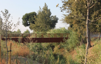
The project aimed to improve the natural value of the Riopudio stream and its surroundings, in order to constitute an environmental reference in articulating the region of Aljarafe, promoting its public use by citizens of the region. The preliminary work consisted in the elimination of the shrub vegetation in order to allow the execution the new profiles and avoid, as far as possible, the subsequent invasion of some very colonizing species. The design of the conditioning of the riverbed has been adapted to the natural conformation of the stream with slopes to avoid erosion and facilitate its subsequent revegetation. In addition, breakwater and dyke structures were installed in order to guarantee the structural stability of the riverbed, helping its stabilisation and thus reducing erosion. When it comes to restoring the vegetation cover of the Riopudio stream, previous action has been taken on the existing one, eliminating invasive species and weeds by clearing them, while preserving and improving the aerial structure of those specimens and copses that are within the areas to be revegetated and which, due to their ecological value, shall be to maintained. The public footpaths have been built along the two margins, creating accesible pedestrians walkways, and allowing the development of educational activities. They will be accesible on foot or by bicycle and, exceptionally, by authorised motorised vehicles for the maintenance of the area. Thirteen wooden footbridges have also been installed. Appart from this, five recreation areas for rest and lesure have been built.

Monitoring surveys and results

This case study hasn’t got any Monitoring survey and results, you can add some by editing the project overview.

Lessons learnt

This case study hasn’t got any lessons learnt, you can add some by editing the project overview.


Image gallery


ShowHideAdditionalImage.png


Catchment and subcatchment

Catchment

River basin district C.H.Guadalquivir
River basin Guadalquivir River

Subcatchment

River name Riopudio Stream
Area category
Area (km2) 1.201.2 km² <br />120 ha <br />
Maximum altitude category
Maximum altitude (m)
Dominant geology
Ecoregion
Dominant land cover
Waterbody ID


Site

Name Riopudio Stream
WFD water body codes
WFD (national) typology
WFD water body name
Pre-project morphology
Reference morphology
Desired post project morphology
Heavily modified water body No
National/international site designation
Local/regional site designations
Protected species present No
Invasive species present No
Species of interest
Dominant hydrology
Dominant substrate
River corridor land use
Average bankfull channel width category
Average bankfull channel width (m)
Average bankfull channel depth category
Average bankfull channel depth (m)
Mean discharge category
Mean annual discharge (m3/s)
Average channel gradient category
Average channel gradient
Average unit stream power (W/m2)


Project background

Reach length directly affected (m)
Project started 2008/08/01
Works started 2015/09/30
Works completed
Project completed
Total cost category
Total cost (k€) 1117653611,176,536 k€ <br />11,176,536,000 € <br />
Benefit to cost ratio
Funding sources Guadalquivir Hydrographic Confederation.

Cost for project phases

Phase cost category cost exact (k€) Lead organisation Contact forename Contact surname
Investigation and design
Stakeholder engagement and communication
Works and works supervision
Post-project management and maintenance
Monitoring


Reasons for river restoration

Mitigation of a pressure
Hydromorphology To improve the natural value of the Riopudio stream and its surroundings, in order to constitute an environmental reference in articulating the region of Aljarafe.
Biology
Physico-chemical
Other reasons for the project To promote the area’s orderly public use by citizens of the region.


Measures

Structural measures
Bank/bed modifications Land movement (the design of the conditioning of the riverbed has been adapted to the natural conformation of the stream with slopes to avoid erosion and facilitate its subsequent revegetation); Defense of the riverbanks ( the breakwater structures foreseen in the project have been placed in order to guarantee the structural stability and the collapses to the riverbed).
Floodplain / River corridor shrub vegetation along the stream area, speacilly the abundant of two currently invasive plants (Arundo donax and Ricinus communis) as well as tall ruderal scrubs; Environmental restoration (eliminating invasive species and weeds by clearing them, while preserving and improving the aerial structure of those specimens and copses that are within the areas to be revegetated and which, due to their ecological value, shall be to maintained)
Planform / Channel pattern
Other Landscaping and cleaning of the area (rubble removal, abandoned houses and uncontrolled dumping); construction of Canadian crossings to prevent the entry of livestock and the enclosure with livestock mesh that protects the planted area and physically delimits it; Wooden footbridges; Public footpaths; Five recreation areas for rest and lesure (equipped with parking areas next to public pathways access, rest areas with urban furniture, trees that allow activities in the shade, containers, rustic bicycle parking and interpretive posters); staggered bollards
Non-structural measures
Management interventions
Social measures (incl. engagement)
Other


Monitoring

Hydromorphological quality elements

Element When monitored Type of monitoring Control site used Result
Before measures After measures Qualitative Quantitative

Biological quality elements

Element When monitored Type of monitoring Control site used Result
Before measures After measures Qualitative Quantitative

Physico-chemical quality elements

Element When monitored Type of monitoring Control site used Result
Before measures After measures Qualitative Quantitative

Any other monitoring, e.g. social, economic

Element When monitored Type of monitoring Control site used Result
Before measures After measures Qualitative Quantitative


Monitoring documents


Additional documents and videos


Additional links and references

Link Description

Supplementary Information

Edit Supplementary Information