Case study:BALLYMONEY RIVERSIDE PARK RESTORATION PROJECT

From RESTORE
Revision as of 16:34, 2 January 2019 by Alexrrc (talk | contribs)
(diff) ← Older revision | Latest revision (diff) | Newer revision → (diff)
Jump to navigation Jump to search
0.00
(0 votes)


To discuss or comment on this case study, please use the discussion page.


Location: 55° 4' 9.30" N, 6° 30' 26.56" W
Loading map...
Left click to look around in the map, and use the wheel of your mouse to zoom in and out.


Project overview

Edit project overview
Status Complete
Project web site
Themes Fisheries, Flood risk management, Habitat and biodiversity, Social benefits, Urban
Country Northern Ireland
Main contact forename Gareth
Main contact surname Greer
Main contact user ID
Contact organisation Rivers Agency Northern Ireland (DARDNI)
Contact organisation web site http://www.dardni.gov.uk/riversagency
Partner organisations Ballymoney Borough Council; Dept Culture Arts and Leisure Inland Fisheries Group; Northern Ireland Environment Agency
This is a parent project
encompassing the following
projects
This case study hasn’t got a picture, you can add one by editing the project overview.

Project summary

Edit project overview to modify the project summary.


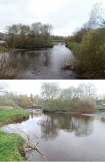
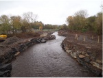
This is an urban project, which aims to return an on-line boating lake on the Ballymoney River, to a productive salmonid stream. The impetus for the project was the ongoing cost of dredging the boating lake, which stimulated broader thinking towards a more sustainable plan for the site. Following a flood risk assessment, a scheme was agreed which entailed; the removal of a low weir, the restoration of a natural channel width, the restoration of natural substrate , the creation of in-channel features and the creation of wetland floodplain habitat which will provide flood storage. The project will be used as a demonstration site for multi-benefit restoration in an urban environment, and as an example of multi-agency working and funding.

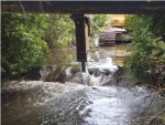
Works included: Removal of low weir to permit natural sediment transport.

Monitoring surveys and results

Edit project overview to modify the Monitoring survey and results.


Pre works assessment included a River Hydromorphology Assessmeent (RHAT) and fisheries survey, and a flood risk assessment. The site will be monitored for several years, with the council monitoring the development of the wetland and impacts on wildfowl, Rivers Agency continuing flood risk assessment, DCAL carrying out fish stock and habitat assessment, and NIEA carry out a reRHAT on regular intervals.

Lessons learnt

Edit project overview to modify the lessons learnt.


The value of a multi-benefit scheme, through joint funding and agreed outcomes. The value of good PR and information from an early stage in project development.


Image gallery


Pond pre works.JPG
for comparison with post works
Weir removal.JPG
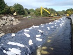
Temporary channel.JPG
New channel being formed.JPG
New channel.JPG
fishery and flow measures
Wetland creation early stages.JPG
ShowHideAdditionalImage.png


Catchment and subcatchment


Site

Name Ballymoney Riveside Park
WFD water body codes GBNI1NB030301220
WFD (national) typology
WFD water body name Ballmoney River
Pre-project morphology Artificial channel
Reference morphology Low gradient passively meandering
Desired post project morphology Low gradient passively meandering, Pool-riffle
Heavily modified water body No
National/international site designation
Local/regional site designations
Protected species present No
Invasive species present No
Species of interest
Dominant hydrology Artificially regulated
Dominant substrate Silt, Cobble, Gravel
River corridor land use Urban
Average bankfull channel width category 5 - 10 m
Average bankfull channel width (m)
Average bankfull channel depth category 0.5 - 2 m
Average bankfull channel depth (m)
Mean discharge category
Mean annual discharge (m3/s)
Average channel gradient category
Average channel gradient
Average unit stream power (W/m2)


Project background

Reach length directly affected (m) 250250 m <br />0.25 km <br />25,000 cm <br />
Project started 2014/04/07
Works started 2014/09/22
Works completed 2014/12/19
Project completed
Total cost category 100 - 500 k€
Total cost (k€)
Benefit to cost ratio
Funding sources Ballymoney Council; DCAL Inland Fisheries (NASCO money); DARD Rivers

Cost for project phases

Phase cost category cost exact (k€) Lead organisation Contact forename Contact surname
Investigation and design 1 - 10 k€ Department of Agriculture & Rural Development Rivers Agency Gareth Greer
Stakeholder engagement and communication 1 - 10 k€ Ballymoney Borough Council Rachel Bain
Works and works supervision 100 - 500 k€ Department of Agriculture & Rural Development Rivers Agency Gareth Greer
Post-project management and maintenance 1 - 10 k€ Ballymoney Borough Council Rachel Bain
Monitoring 1 - 10 k€ NIEA Mary Toland

Supplementary funding information

DARD Rivers contributed 10k towards the overall cost of the project, and acted as contractor for the scheme, employed by the council.. DCAL Inland Fisheries contributed 30k through NASCO (North Atlantic Salmon Conservation Organisation) funding. All other costs covered by Ballymoney Borough Council


Reasons for river restoration

Mitigation of a pressure Impoundments (not hydropower), Urbanisation
Hydromorphology Continuity of sediment transport, Freshwater flow regime, Width & depth variation, Channel pattern/planform, Quantity & dynamics of flow
Biology Fish: Abundance
Physico-chemical
Other reasons for the project improving local park; education; wetland creatio; flood storage


Measures

Structural measures
Bank/bed modifications Weir removal, Addition of substrate and in channel features, Alteration in channel dimensions, Weir removal
Floodplain / River corridor Creation of wetland, Creation of ponds and scrapes
Planform / Channel pattern Diversification of in-channel features, Meandering channel
Other
Non-structural measures
Management interventions management of wetland by council (new area of work)
Social measures (incl. engagement) Community Education, Public amenity and perception
Other


Monitoring

Hydromorphological quality elements

Element When monitored Type of monitoring Control site used Result
Before measures After measures Qualitative Quantitative
Channel pattern/planform Yes No Yes No No
Freshwater flow regime Yes No Yes No No

Biological quality elements

Element When monitored Type of monitoring Control site used Result
Before measures After measures Qualitative Quantitative
Fish Yes No Yes No No
[[]] No No No No No

Physico-chemical quality elements

Element When monitored Type of monitoring Control site used Result
Before measures After measures Qualitative Quantitative

Any other monitoring, e.g. social, economic

Element When monitored Type of monitoring Control site used Result
Before measures After measures Qualitative Quantitative
Channel bed morphology. Yes No Yes No No


Monitoring documents


Additional documents and videos


Additional links and references

Link Description

Supplementary Information

Edit Supplementary Information

This is a partnership project, involving government departments and the local council. The project was opportunistic in nature, being developed due to the maintenance costs of the current situation. The benefits are as much social and educational as environmental. Monitoring using RHAT and fish surveys will commence next year, once the project has "settled". It will be used as a demonstration site for urban restoration