Case study:Restoring the natural dynamics of the upper Adour
This case study is pending approval by a RiverWiki administrator.
Project overview
| Status | Complete |
|---|---|
| Project web site | |
| Themes | Flood risk management, Habitat and biodiversity, Hydromorphology |
| Country | France |
| Main contact forename | Jean-Luc |
| Main contact surname | Cazaux |
| Main contact user ID | |
| Contact organisation | |
| Contact organisation web site | http://www.haute-bigorre.fr/ |
| Partner organisations | |
| Parent multi-site project | |
| This is a parent project encompassing the following projects |
No |
Project summary
in order to protect
nearby land and homes from flooding, work was
regularly done on the river with the main objective
being to narrow the river bed and to create a single
channel. In the process, alluvial bars along the entire
upstream section were systematically removed and
the resulting sediment was spread along the banks to form bunds. This contributed to incision of the river
bed and disconnection of side channels from the
main channel. It also resulted in significantly destabilising
the river banks.
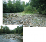
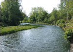
The works consisted of removing the bunds by regrading the banks and modifying the management techniques for accumulated debris and dead wood. The side channels that had been cut off were restored and a network of secondary channels was created to manage flooding. Bank-protection systems were installed only as needed and exclusively using bio-engineering or mixed techniques. Sectors with sparse vegetation were planted. Finally, efforts were made to counter the development of Japanese knotweed, an invasive species.
■ Post-restoration management
A track parallel to the banks, at least ten metres from the river in the riparian vegetation and open only to maintenance personnel and local land owners, was created to facilitate maintenance and provide access to the river in the event urgent action is required during a flood. Vegetation is cut on a very selective basis in order to preserve the habitats of the animals that depend on the aquatic environments. Management of accumulated debris and jams is kept to a minimum. An assessment now determines whether debris and jams constitute an effective obstacle to the flow of water and only the “risky” situations are managed by removing any vegetation and raking the sediment to a depth of 80 cm.
Monitoring surveys and results
A pre-works survey showing the hydro-geomorphological
functioning of the Adour was carried out. It
was based on expert opinion and observations of the
river’s morphological characteristics (flow pattern,
erosion zones, disconnected secondary channels) and
any changes over time. Since the end of the works,
no specific monitoring has been carried out, with the
exception of regular observations in the field.
The restoration works diversified the flow pattern and habitats, making possible salmonid reproduction. An immediate effect of reconnecting the side channels was an increase in the mobility space of the river and a decrease in flooding risks (greater dissipation of energy, a reduction in vertical and lateral erosion processes, stabilisation of banks, etc.).
The awareness on the part of the elected officials of the need to protect biodiversity and the creation of a comprehensive, integrated and pragmatic approach to river management, in close contact with the local population, guarantee the success of the project. The guiding principles behind the restoration and maintenance works have now been adopted by the towns downstream.
The intermunicipal association has also made significant financial savings thanks to the halt of the previous large-scale and expensive work programmes.
Lessons learnt
Image gallery
|
Catchment and subcatchment
Site
Project background
Cost for project phases
Reasons for river restoration
Measures
MonitoringHydromorphological quality elements
Biological quality elements
Physico-chemical quality elements
Any other monitoring, e.g. social, economic
Monitoring documents
Additional documents and videos
Additional links and references
Supplementary InformationEdit Supplementary Information
| ||||||||||||||||||||||||||||||||||||||||||||||||||||||||||||||||||||||||||||||||||||||||||||||||||||||||||||||||||||||||||||||||||||||||||||||||||||||||||||||||||||||||||||||||||||


