Case study:Refilling the meanders of the Colostre

From RESTORE
Revision as of 14:43, 5 June 2017 by Alexrrc (talk | contribs)
(diff) ← Older revision | Latest revision (diff) | Newer revision → (diff)
Jump to navigation Jump to search
0.00
(0 votes)


To discuss or comment on this case study, please use the discussion page.


Location: 43° 47' 59.23" N, 6° 2' 28.12" E
Loading map...
Left click to look around in the map, and use the wheel of your mouse to zoom in and out.


Project overview

Edit project overview
Status Complete
Project web site
Themes
Country France
Main contact forename Vincent
Main contact surname Duru
Main contact user ID
Contact organisation FDPPMA Alpes-de-Haute-Provence
Contact organisation web site
Partner organisations
Parent multi-site project

Case_study:Plan dèpartemental pour la protection du milieu aquatique et la gestion des resources piscicoles

This is a parent project
encompassing the following
projects
No
This case study hasn’t got a picture, you can add one by editing the project overview.

Project summary

Edit project overview to modify the project summary.


The Colostre, a tributary of the River Verdon, is a typically Mediterranean river, with very low water levels upstream of Riez and flash flooding due to storms. The Colostre constitutes one of the only breeding grounds for brown trout. The beaver has also been recorded in this area. In the 1960s, following exceptional summer flooding, hydraulic improvements were made in order to modify the longitudinal profile of the river (resizing, straightening of the river and creation of weirs). These developments degraded the habitats of the river and caused significant erosion of the river banks. In response to this situation, in 1996, state fishing institutes and the local fishing association, initiated a protection Plan with the aim of free movement of salmonids and rediversification of habitats. The restoration measures formed part of the implementation of this plan. Thirteen meanders were restored. The disconnected meanders had not been filled in and instead had been left uncultivated; most of them thus remained identifiable. The first stage consisted of restoring access to the meanders by removing the poplars planted during the resizing of the river. Next, the current was diverted towards the old meanders which remained visible. The entrance to the straight channel was blocked using a submersible weir (consisted of timber billets covered with gravels, geotextile and protective mesh). The downstream part of the straight section was not closed off in order to allow for the dispersal of floodwaters. In areas in which the meanders were not identified, various experimental habitat diversification developments were carried out and weirs were removed or modified.

Monitoring surveys and results

This case study hasn’t got any Monitoring survey and results, you can add some by editing the project overview.

Lessons learnt

This case study hasn’t got any lessons learnt, you can add some by editing the project overview.


Image gallery


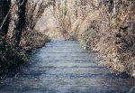
The Colostre canalised before restoration (1999).
One of the Colostre meanders (2009).
ShowHideAdditionalImage.png


Catchment and subcatchment

Catchment

River basin district Alpes-de-Haute-Provence
River basin Rhône-Mediterranean

Subcatchment

River name Colostre
Area category 100 - 1000 km²
Area (km2) 215 km²21,500 ha <br />
Maximum altitude category
Maximum altitude (m)
Dominant geology
Ecoregion Alps
Dominant land cover
Waterbody ID


Site

Name Regional Natural Park of Verdon
WFD water body codes FRDR251
WFD (national) typology
WFD water body name
Pre-project morphology Single channel, Straight
Reference morphology Sinuous
Desired post project morphology
Heavily modified water body true
National/international site designation EU - Special Protected Area
Local/regional site designations
Protected species present
Invasive species present
Species of interest
Dominant hydrology Quick run-off, Artificially regulated
Dominant substrate
River corridor land use
Average bankfull channel width category 2 - 5 m
Average bankfull channel width (m) 44 m <br />0.004 km <br />400 cm <br />
Average bankfull channel depth category
Average bankfull channel depth (m)
Mean discharge category
Mean annual discharge (m3/s) 0.670.67 m³/s <br />670 l/s <br />
Average channel gradient category
Average channel gradient 1e-005
Average unit stream power (W/m2) 0.0164267250.0164 W/m² <br />


Project background

Reach length directly affected (m) 11000 m11 km <br />1,100,000 cm <br />
Project started 1996/01/01
Works started 1999/01/01
Works completed 2001/01/01
Project completed
Total cost category 50 - 100 k€
Total cost (k€) 66 k€66,000 € <br />
Benefit to cost ratio
Funding sources Water Agency, Regional Council, Dèpartment-level Council, Higher Fishing Council, Local fishing associations

Cost for project phases

Phase cost category cost exact (k€) Lead organisation Contact forename Contact surname
Investigation and design
Stakeholder engagement and communication
Works and works supervision 50 - 100 k€ 66 k€66,000 € <br /> Conseil Supérior de la Pêche-Departmental Brigade
Post-project management and maintenance Conseil Général (Départment Level Council)
Monitoring Conseil Supérior de la Pêche-Departmental Brigade


Reasons for river restoration

Mitigation of a pressure
Hydromorphology Continuity for organisms, Continuity of sediment transport, Width & depth variation, Structure & condition of riparian zones, Channel pattern/planform
Biology Fish: Abundance, Fish: Disturbance-sensitive species
Physico-chemical
Other reasons for the project


Measures

Structural measures
Bank/bed modifications Weir removal
Floodplain / River corridor
Planform / Channel pattern Removal of poplars in old meanders, Re-meandering
Other
Non-structural measures
Management interventions
Social measures (incl. engagement) Agreement with the owners, Public meeting
Other River contract


Monitoring

Hydromorphological quality elements

Element When monitored Type of monitoring Control site used Result
Before measures After measures Qualitative Quantitative

Biological quality elements

Element When monitored Type of monitoring Control site used Result
Before measures After measures Qualitative Quantitative
Fish: Species composition Yes Yes Yes Improvement
Macrophytes & phytobenthos: Taxonomic composition Yes Improvement

Physico-chemical quality elements

Element When monitored Type of monitoring Control site used Result
Before measures After measures Qualitative Quantitative

Any other monitoring, e.g. social, economic

Element When monitored Type of monitoring Control site used Result
Before measures After measures Qualitative Quantitative
Presence of beavers Yes Improvement


Monitoring documents


Additional documents and videos


Additional links and references

Link Description

Supplementary Information

Edit Supplementary Information