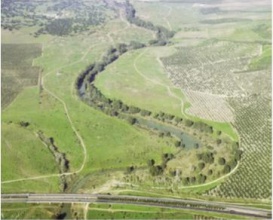
Case study:Guadiamar Green Corridor Project

From RESTORE
Revision as of 11:51, 1 June 2017 by Alexrrc (talk | contribs)
(diff) ← Older revision | Latest revision (diff) | Newer revision → (diff)
Jump to navigation Jump to search
0.00
(0 votes)


To discuss or comment on this case study, please use the discussion page.


Location: 37° 21' 17.55" N, 6° 14' 1.36" W
Loading map...
Left click to look around in the map, and use the wheel of your mouse to zoom in and out.


Project overview

Edit project overview
Status Complete
Project web site
Themes Environmental flows and water resources, Fisheries, Habitat and biodiversity, Water quality
Country Spain
Main contact forename MARM
Main contact surname MARM
Main contact user ID
Contact organisation Junta de Andalucía
Contact organisation web site
Partner organisations
Parent multi-site project
This is a parent project
encompassing the following
projects
No
Project picture

Project summary

Edit project overview to modify the project summary.


In April 1998 there was a breach in a tailings pond in the Guadiamar River area, causing a spill of 6 million cubic hectometres of sludges with a high concentration of heavy metals (zinc, lead, arsenic, copper, antimony, thallium, cadmium). The objectives of this project were the Guadiamar River ecological restoration, removal of sludge and effluent pollutants, and creating a green corridor. In addition, we conducted a strategic planning for the different communities of macroinvertebrates, fish, reptiles, birds... The project included several monitoring programs and analysis, in particular, water quality, to see if the level of pollutants had decreased. This project of restoration and recovery of the area was carried out between 1998 and 2005. The total budget for carry out the rehabilitation and restoration of 62 Km of the Guadiamar River was 165.396.261€. The financing came from the MARM and the Consejería of Environment, Andalucía.

Monitoring surveys and results

This case study hasn’t got any Monitoring survey and results, you can add some by editing the project overview.

Lessons learnt

This case study hasn’t got any lessons learnt, you can add some by editing the project overview.


Image gallery


Aerial view
Map of the area affected by the flood
Photo of the Agrio River and Guadiamar floodplain after flood of toxic sludges.
Cleaning and conditioning of slopes
Mechanical removal of sludges from the riverbed
Aerial view of Guadiamar river floodplain after works
Guadiamar riverside forest
ShowHideAdditionalImage.png


Catchment and subcatchment

Catchment

River basin district C.H.Guadalquivir
River basin Guadalquivir

Subcatchment

River name Guadalquivir
Area category
Area (km2)
Maximum altitude category Less than 100 m
Maximum altitude (m) 50 m0.05 km <br />5,000 cm <br />
Dominant geology
Ecoregion Ibero-Macaronesian
Dominant land cover Extensive agriculture
Waterbody ID


Other case studies in this subcatchment: Control and permeabilization of the marsh to the river, the Brazo de la Torre and Entremuros, Recovery "CañoTravieso", Recovery of the functionality of Brazo de la Torre, Restoration of streams Chico Soto, Soto Grande and Arroyo de la Laguna de los Reyes, Restoration of the stream of the Partido


Site

Name Caño Guadiamar
WFD water body codes
WFD (national) typology
WFD water body name
Pre-project morphology Sinuous
Reference morphology Sinuous
Desired post project morphology
Heavily modified water body true
National/international site designation
Local/regional site designations
Protected species present
Invasive species present
Species of interest
Dominant hydrology
Dominant substrate Clay, Silt
River corridor land use Extensive agriculture
Average bankfull channel width category
Average bankfull channel width (m)
Average bankfull channel depth category
Average bankfull channel depth (m)
Mean discharge category
Mean annual discharge (m3/s)
Average channel gradient category
Average channel gradient
Average unit stream power (W/m2)


Project background

Reach length directly affected (m) 12000 m12 km <br />1,200,000 cm <br />
Project started 1998/04/01
Works started
Works completed 2005/11/01
Project completed
Total cost category more than 10000 k€
Total cost (k€)
Benefit to cost ratio
Funding sources

Cost for project phases

Phase cost category cost exact (k€) Lead organisation Contact forename Contact surname
Investigation and design
Stakeholder engagement and communication
Works and works supervision Junta de Andalucía
Post-project management and maintenance
Monitoring


Reasons for river restoration

Mitigation of a pressure Pollution incident
Hydromorphology Connection to groundwaters, Structure & condition of riparian zones, Channel pattern/planform
Biology
Physico-chemical Acid neutralising capacity
Other reasons for the project Landscape enhancement


Measures

Structural measures
Bank/bed modifications Recovering connectivity longitudinal and transversal
Floodplain / River corridor Buffer strips, Recovery of dynamic river system, Restoring riparian vegetation
Planform / Channel pattern Remove drains and pipes
Other Elimination of pollutants due to the discharge of toxic sludge, Recovering natural habitats, Recovering natural landscapes
Non-structural measures
Management interventions
Social measures (incl. engagement)
Other


Monitoring

Hydromorphological quality elements

Element When monitored Type of monitoring Control site used Result
Before measures After measures Qualitative Quantitative
Connection to groundwaters Yes Yes Yes Yes Awaiting results
Structure & condition of riparian zones Yes Yes Yes Yes Awaiting results
Channel pattern/planform Yes Yes Yes Awaiting results

Biological quality elements

Element When monitored Type of monitoring Control site used Result
Before measures After measures Qualitative Quantitative

Physico-chemical quality elements

Element When monitored Type of monitoring Control site used Result
Before measures After measures Qualitative Quantitative
Acid neutralising capacity Yes Yes Yes Improvement

Any other monitoring, e.g. social, economic

Element When monitored Type of monitoring Control site used Result
Before measures After measures Qualitative Quantitative
Landscape enhancement Yes Yes Yes Yes Improvement


Monitoring documents


Additional documents and videos


Additional links and references

Link Description

Supplementary Information

Edit Supplementary Information