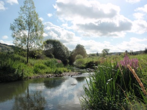
Case study:Eau Blanche River (Walphy - LIFE project)
This case study is pending approval by a RiverWiki administrator.
Project overview
| Status | Complete |
|---|---|
| Project web site | |
| Themes | Habitat and biodiversity, Hydromorphology, Monitoring |
| Country | Belgium |
| Main contact forename | Alexandre |
| Main contact surname | Peeters |
| Main contact user ID | User:AlexBE |
| Contact organisation | Service Public de Wallonie (SPW) |
| Contact organisation web site | http://walphy.be |
| Partner organisations | |
| This is a parent project encompassing the following projects |
Bocq river (Walphy - LIFE project) |
Project summary
n the context of fulfilling the Water Framework Directive requirements, the LIFE+ project Walphy allowed experimental restoration projects to be undertaken on two medium-size catchments of the Meuse basin in Wallonia (Belgium) between 2009 and 2014: the Bocq catchment and the Eau Blanche Catchment. This five-year long project was funded by the European Union and the Service Public de Wallonie (SPW). It involved three institutions: the SPW was in charge of the experimental restoration projects while the Universities of Liège and Namur were responsible for evaluating the success of the restoration projects.
The Eau Blanche is a medium-size gravel-bed river. Its downstream reach (13 km) is characterized by a low gradient (1-2 ‰), a low energy (specific stream power at the bankfull stage: 20 W/m²) and a wide floodplain (around 600 m). Its channel have been straightened and embanked over the last few centuries (sinuosity index decreased from 1.6 to 1.1), which has led to significant loss of habitat.
A multi-scale assessment of hydromorphological conditions of the Eau Blanche catchment has led to several restoration projects on a total length 6 km. They consist of measures of different ambitions such as reconnecting remnant meander, meandering river channel and habitat diversification. In addition, we undertook locally to improve fish shelters and spawning areas.
Monitoring surveys and results
The success of the restoration projects was evaluated on the basis of a multi-disciplinary monitoring.
Hydromorphology was evaluated on three restored sites using microhabitat survey and three indices of physical quality. For all sites, hydromorphology was significantly improved 10-20 months post-rehabilitation, through the diversification of flows (depth, substrate, water velocity) and the creation of habitats (e.g. fish shelters, spawning areas and woody debris). The most positive effects were observed for the most ambitious projects (meandering river channel and reconnecting remnant meander compared to habitat diversification).
Biological quality, based on macroinvertebrates and fish communities, has generally showed a status quo or a slight increase 10-20 months post-completion. As for hydromorphology, we might conclude that the most ambitious rehabilitation measures have resulted in the most positive effects. However, it would be prudent to await the results of the next monitoring surveys (4 years post-completion).
The geomorphological monitoring has focused on the effect of rehabilitation measures on river dynamic (bedload transport, bank erosion) and the effectiveness of spawning gravel rehabilitation.
Lessons learnt
- Despite the short period of time (5 years) of this project, we realized afterwards the importance of achieving a multi-scale assessment and an initial state (pre-restoration) prior to restoration work.
- We implemented a wide range of demonstration techniques and we compared them in terms of cost-effectiveness (see the Manual of River Restoration Techniques on http://www.walphy.be/index.php?page=guide-technique).
- Most of the restoration projects could be implemented without acquiring the land but rather through negociations with the local community. This underlines the importance of engaging the local community.
- The time span of the project allowed us only 1-2 years of monitoring (post-restoration). Fortunately, the SPW funded a long-term monitoring (>3 years), which is crucial for accurate evaluation of success, especially for biological indicators.
- Finally, we hope the project to give a boost to future restoration projets in Wallonia.
Image gallery
|
Catchment and subcatchment
Site
Project background
Cost for project phases
Reasons for river restoration
Measures
MonitoringHydromorphological quality elements
Biological quality elements
Physico-chemical quality elements
Any other monitoring, e.g. social, economic
Monitoring documents
Additional documents and videos
Additional links and references
Supplementary InformationEdit Supplementary Information
| ||||||||||||||||||||||||||||||||||||||||||||||||||||||||||||||||||||||||||||||||||||||||||||||||||||||||||||||||||||||||||||||||||||||||||||||||||||||||||||||||||||||||||||||||||

