Case study:Splash
Project overview
| Status | Complete |
|---|---|
| Project web site | http://www.wyeuskfoundation.org/projects/splash.php |
| Themes | Habitat and biodiversity, Social benefits |
| Country | Wales |
| Main contact forename | Stephen |
| Main contact surname | Marsh-Smith |
| Main contact user ID | |
| Contact organisation | Wye & Usk Foundation |
| Contact organisation web site | http://www.wyeuskfoundation.org/ |
| Partner organisations | Environmental Agency Wales |
| Parent multi-site project | |
| This is a parent project encompassing the following projects |
No |
Project summary
Splash is a Wales Assembly Government Fund, managed by Environment Agency Wales, and is designed to assist and enable projects that improve public access to Wales’s waterways for recreational and educational activities. The Foundation received Splash funding from 2008-2010 to continue the Passport Scheme and to facilitate Canoe Access Arrangements on those sections of the Wye and Usk that have no right of navigation.
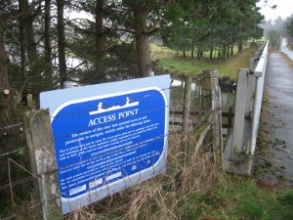
The access point at Llangurig on the upper Wye, established by the Foundation with Splash funding.The Buckland South beat on the Usk, which joined the Passport scheme in 2009.
Our first project (October 2008 – March 2009) was the "Canoe Access Reconciliation Project" (CARP), which extended and maintained the previous access agreements pioneered by the Foundation with WAG and CCW for the upper Wye & Usk. Within CARP (total budget £10,000) we extended the agreements to cover the Rhayader to Llanwrthwl stretch of the upper Wye (including signage and website information) and installed a new webcam at Rhayader.
At the same time Splash also contributed £20,000 towards the 2009 Passport. With this we produced and distributed the 2009 brochure, signed up 7 new beats in Wales, improved access to 15 beats and installed 2 new webcams.
Our second tranche of Splash funding (August 2008 to March 2010) included a further £13,000 for canoe access and £10,000 for the Passport scheme. Within this we extended the access agreements on the upper Wye from Llangurig downstream to Rhayader and investigated extending them below Crickhowell on the Usk. We also produced the 2010 Passport booklet with 4 new Welsh beats.
Splash funding has enabled us to continue and expand the Wye and Usk Passport and invest in, maintain and extend canoe access agreements in the face of increasing pressure for free and open access to all Welsh rivers. The Foundation believes that access arrangements should be voluntary and agreed amongst stakeholders: a free for all would not be in the best interests of any of the parties.
- Barrier removal and fish pass construction
- River habitat improvement and restoration
- Water quality improvements
- Fishery infrastructure improvements and marketing
- Management of invasive species
Monitoring surveys and results
Lessons learnt
Image gallery
|
Catchment and subcatchment
Site
Project background
Cost for project phases
Reasons for river restoration
Measures
MonitoringHydromorphological quality elements
Biological quality elements
Physico-chemical quality elements
Any other monitoring, e.g. social, economic
Monitoring documents
Additional documents and videos
Additional links and references
Supplementary InformationEdit Supplementary Information
| ||||||||||||||||||||||||||||||||||||||||||||||||||||||||||||||||||||||||||||||||||||||||||||||||||||||||||||||||||||||||||||||||||||||||||||||||||||||||||||||||||||||||||||||||||

